Even een sfeerverhogende bijdrage van mijn kant  &
& 
Broad overview of the latest EC32 update
The anomaly on the 17th. HP eastern Pacific with LP Alaska and California. HP N. Canada and a trough running a fair way south mid Atlantic. and ridging to the east of the UK. So although LP is dominating the Atlantic the HP is still influencing the UK bringing a warm SW flow. Soon to change.
During the next week the ridge soon collapses and the trough moves east to be be over the UK by the 25th with a familiar story upstream with LP Alaska, trough western N. America and HP NE Canada. Surface analysis for the UK very unsettled at first with some wintry outbreaks, particularly in the north but perhaps improving later nearer the 25th. Temps generally a little above average.
This scenario holds good until about the 29th when the trough begins to lose it’s influence and HP pushes a little north from the SW and S. Still a flow from a westerly quadrant but a tad more benign so longer periods of settled weather with temps around average or a little above.
Summary
Broadly speaking from the 18th until the 8th January The UK will be in a flow from a westerly quadrant bringing some wet and windy weather at times, particularly in the north, interspersed with some calmer ridging conditions in the wake of the latter as HP edges up from the SW/S. Temps initially above average but becoming average but they will vary a fair bit around the norm,
The NAO and AO are positive throughout the period except the latter does slip negative at the end.
Stewart heeft zojuist zijn visie op het stratosfeer topic gegeven.
I wonder, do we have a slow burner ? A slow burner that perhaps leads to a more assured route to a warming event in January ?
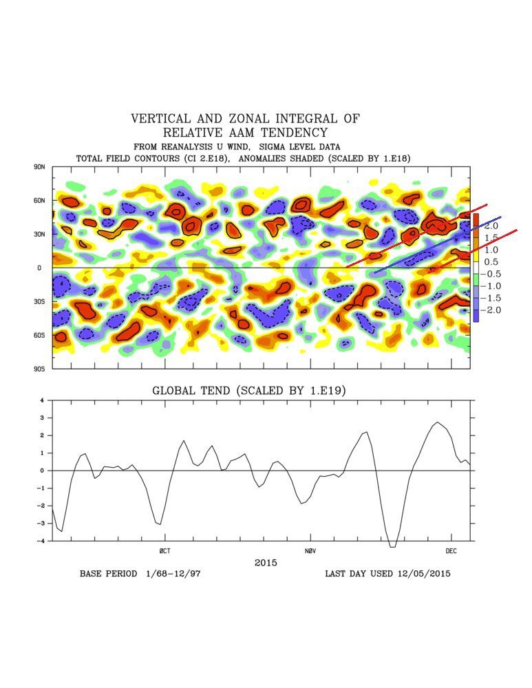
The pattern as of yesterday and for the next 7 days is within the envelope for generating Wave 1 activity in the upper stratosphere with a deep upper trough centred across the central North Pacific. The atmosphere is also reflecting a strong El Nino passage with relative angular momentum topping +2SD.
Both this morning's EC EPS and GEFS mean at 10 hPa show remarkable consistency on a big North Pacific ridge and slightly displaced upper vortex. We have also operational GFS showing warming at 1hPa, peaking around the 22nd-23rd December. That is much more in line with what we would expect given the tropospheric forcing right now and lagged impacts 12-21 days. It also underlines the operational GFS' propensity for rushing stratospheric responses.
A couple of things to consider where we might go from here.
The atmosphere is starting to take on a well defined rhythm tied into tropical forcing. A recent flare up of tropical convection in the Indian Ocean has generated a lagged El Nino response. We expect to see a slight waning of El Nino next week as the North Pacific ridge is pushed northwards and the atmosphere becomes more La Nina like for a time. As a result, the lagged stratospheric response will be for a backing off of the Wave 1. We can see this waxing and waning in tendency in relative angular momentum with pulses of westerly (red) and easterly (blue) tendency being fluxed poleward over time.
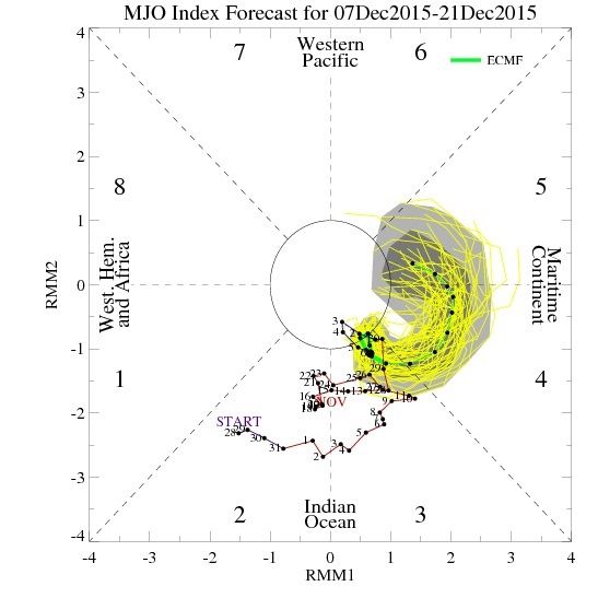
Thereafter, MJO forecasts are interesting in developing another eastward wave through the Indian Ocean and into the Maritime Continent. That should give the atmosphere another kick and develop a bigger upward trend in angular momentum and further wave 1 and possibly wave 2 forcing during the final third of December and into January.
EC monthly forecast very consistent with this, and should be reflected in the stratosphere during the first week of January. In other words, enjoy the current wave 1 period, but don't be surprised if it doesn't result in a warming event just yet. More focus I would suggest on the forecasts over Christmas week.
https://forum.netweather.tv/topic/84231-stratosphere-temperature-watch-20152016/?page=12
Plaatjes die erbij horen
& Broad overview of the latest EC32 update
The anomaly on the 17th. HP eastern Pacific with LP Alaska and California. HP N. Canada and a trough running a fair way south mid Atlantic. and ridging to the east of the UK. So although LP is dominating the Atlantic the HP is still influencing the UK bringing a warm SW flow. Soon to change.
During the next week the ridge soon collapses and the trough moves east to be be over the UK by the 25th with a familiar story upstream with LP Alaska, trough western N. America and HP NE Canada. Surface analysis for the UK very unsettled at first with some wintry outbreaks, particularly in the north but perhaps improving later nearer the 25th. Temps generally a little above average.
This scenario holds good until about the 29th when the trough begins to lose it’s influence and HP pushes a little north from the SW and S. Still a flow from a westerly quadrant but a tad more benign so longer periods of settled weather with temps around average or a little above.
Summary
Broadly speaking from the 18th until the 8th January The UK will be in a flow from a westerly quadrant bringing some wet and windy weather at times, particularly in the north, interspersed with some calmer ridging conditions in the wake of the latter as HP edges up from the SW/S. Temps initially above average but becoming average but they will vary a fair bit around the norm,
The NAO and AO are positive throughout the period except the latter does slip negative at the end.
Stewart heeft zojuist zijn visie op het stratosfeer topic gegeven.
I wonder, do we have a slow burner ? A slow burner that perhaps leads to a more assured route to a warming event in January ?
The pattern as of yesterday and for the next 7 days is within the envelope for generating Wave 1 activity in the upper stratosphere with a deep upper trough centred across the central North Pacific. The atmosphere is also reflecting a strong El Nino passage with relative angular momentum topping +2SD.
Both this morning's EC EPS and GEFS mean at 10 hPa show remarkable consistency on a big North Pacific ridge and slightly displaced upper vortex. We have also operational GFS showing warming at 1hPa, peaking around the 22nd-23rd December. That is much more in line with what we would expect given the tropospheric forcing right now and lagged impacts 12-21 days. It also underlines the operational GFS' propensity for rushing stratospheric responses.
A couple of things to consider where we might go from here.
The atmosphere is starting to take on a well defined rhythm tied into tropical forcing. A recent flare up of tropical convection in the Indian Ocean has generated a lagged El Nino response. We expect to see a slight waning of El Nino next week as the North Pacific ridge is pushed northwards and the atmosphere becomes more La Nina like for a time. As a result, the lagged stratospheric response will be for a backing off of the Wave 1. We can see this waxing and waning in tendency in relative angular momentum with pulses of westerly (red) and easterly (blue) tendency being fluxed poleward over time.
Thereafter, MJO forecasts are interesting in developing another eastward wave through the Indian Ocean and into the Maritime Continent. That should give the atmosphere another kick and develop a bigger upward trend in angular momentum and further wave 1 and possibly wave 2 forcing during the final third of December and into January.
EC monthly forecast very consistent with this, and should be reflected in the stratosphere during the first week of January. In other words, enjoy the current wave 1 period, but don't be surprised if it doesn't result in a warming event just yet. More focus I would suggest on the forecasts over Christmas week.
https://forum.netweather.tv/topic/84231-stratosphere-temperature-watch-20152016/?page=12
Plaatjes die erbij horen
„Et nul ne se connait tant qu'il n'a pas souffert, „C'est une dure loi, mais une loi suprème, „Vieille comme le monde et la fatalité, „Qu'l nous faut du malheur regevoir le baptéme, ~Et qu'a ce triste prix tout doit étre acheté. „Les moissons pour murir out besoin de rosée, „Pour vivre et pour sentir l'homme a besoin de pleura, „La joie a pour symbole une plante brisée, „Humide encore de pluie et couverte de fleurs."