Judah Cohen is iets optimistischer van toon.
Hij verwacht een negatieve AO in de loop van januari, mogelijk een SSW.
'We have been discussing the polar vortex model developed here at AER that predicts the strength of the polar vortex one month in advance. As we discussed in the blog since mid-November, the model was predicting the polar vortex to become disturbed the third week of December, which just ended this past weekend. The polar vortex model also predicted a similar perturbing of the stratospheric polar vortex in the first week of January, which is now being predicted by the weather models. And as we have been discussing, the polar vortex model predicts an even bigger event the second week of January. Now the model predicts even further perturbing of the polar vortex beyond the second week of January. As we discussed above the predicted atmospheric circulation is nearly optimal for the vertical transfer of energy from the troposphere to the stratosphere that results in weakening of the polar vortex. Therefore, based on the polar vortex model and the upcoming atmospheric circulation pattern, we are anticipating more upward pulses of WAFz and perturbing of the polar vortex. If the predicted atmospheric circulation pattern is correct and our expectations of more upward pulses of WAFz is correct, this should be sufficient to force a sudden stratospheric warming (SSW) beginning sometime in mid-January. And if our expectations of a weakened polar vortex verify, this will likely favor an increased likelihood of severe winter weather across the continents of the Northern Hemisphere.'
Hij maakt eerder in zijn betoog wel een uitzondering voor West-Europa, dat is waarschijnlijk als laatste aan de beurt voor (langere) winterkou.
[Edit]
Citaat Cohen:
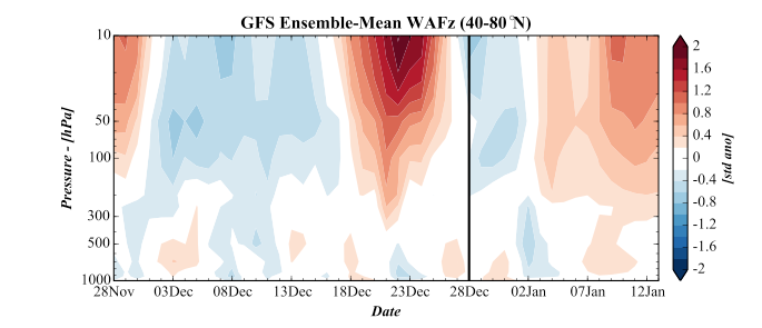
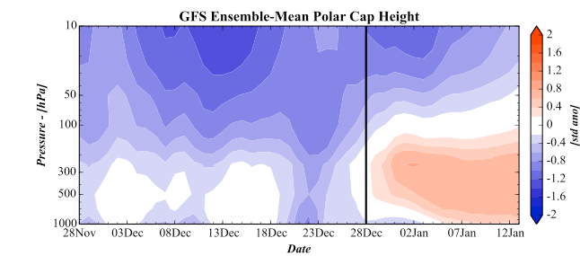
'A likely contribution to the ongoing cooling trend in temperatures across southeastern Canada and the Eastern United States was the strong pulse of vertical transfer of energy from the troposphere to the stratosphere or vertical wave activity flux (WAFz) over the past week (Figure 7). Though it only led to a modest disturbing of the polar vortex, it has initiated some stretching or elongation of the polar vortex that is predicted to continue (Figure 8). The counter clockwise flow around the stratospheric polar vortex is resulting in increased cross-polar flow from Siberia into eastern North America and the predicted cooling trend across the Eastern United States. Following the circulation of air downstream towards Europe results in a strong onshore or mild maritime flow into Europe. For now the onshore component of air across Western Europe is predicted, in the near term at least, to inhibit the easterly flow of much colder air from Eastern Europe. This pattern is reminiscent of the flow around the polar vortex the past two winters with a cold northerly flow of air into the Eastern United States and a strong mild westerly flow of air into Europe. However we do believe that this pattern is still evolving and more changes are expected. As long as the atmospheric energy transfer remains active, the pattern could remain highly variable, especially along the edges of the continents and in the regions of the storm track, which include the Eastern United States, Western Europe and East Asia. One exception may be Siberia, with the AO now predicted to be negative for an extended period, Siberia is likely to remain cold as well.'
en verder:
'The circulation pattern for the end of week two shows strong positive geopotential heights across northwest Eurasia and the Barents Kara Seas with downstream troughing over East Asia and the North Pacific with more troughing upstream in the eastern North Atlantic (Figure 4b). This is referred to the tripole pattern that we have shown is favorable for increasing the energy transfer or wave activity flux between the troposphere and the stratosphere (Cohen and Jones 2012). Furthermore the wave pattern is strikingly a wave two pattern that often results in increased energy transfer into the stratospheric polar vortex that results in polar vortex splits. Therefore we continue to anticipate further energy pulses beyond those predicted in Figure 7, ongoing perturbing and weakening of the polar vortex and eventually expect the polar vortex to split into two pieces.'
Hij verwacht een negatieve AO in de loop van januari, mogelijk een SSW.
'We have been discussing the polar vortex model developed here at AER that predicts the strength of the polar vortex one month in advance. As we discussed in the blog since mid-November, the model was predicting the polar vortex to become disturbed the third week of December, which just ended this past weekend. The polar vortex model also predicted a similar perturbing of the stratospheric polar vortex in the first week of January, which is now being predicted by the weather models. And as we have been discussing, the polar vortex model predicts an even bigger event the second week of January. Now the model predicts even further perturbing of the polar vortex beyond the second week of January. As we discussed above the predicted atmospheric circulation is nearly optimal for the vertical transfer of energy from the troposphere to the stratosphere that results in weakening of the polar vortex. Therefore, based on the polar vortex model and the upcoming atmospheric circulation pattern, we are anticipating more upward pulses of WAFz and perturbing of the polar vortex. If the predicted atmospheric circulation pattern is correct and our expectations of more upward pulses of WAFz is correct, this should be sufficient to force a sudden stratospheric warming (SSW) beginning sometime in mid-January. And if our expectations of a weakened polar vortex verify, this will likely favor an increased likelihood of severe winter weather across the continents of the Northern Hemisphere.'
Hij maakt eerder in zijn betoog wel een uitzondering voor West-Europa, dat is waarschijnlijk als laatste aan de beurt voor (langere) winterkou.
[Edit]
Citaat Cohen:
'A likely contribution to the ongoing cooling trend in temperatures across southeastern Canada and the Eastern United States was the strong pulse of vertical transfer of energy from the troposphere to the stratosphere or vertical wave activity flux (WAFz) over the past week (Figure 7). Though it only led to a modest disturbing of the polar vortex, it has initiated some stretching or elongation of the polar vortex that is predicted to continue (Figure 8). The counter clockwise flow around the stratospheric polar vortex is resulting in increased cross-polar flow from Siberia into eastern North America and the predicted cooling trend across the Eastern United States. Following the circulation of air downstream towards Europe results in a strong onshore or mild maritime flow into Europe. For now the onshore component of air across Western Europe is predicted, in the near term at least, to inhibit the easterly flow of much colder air from Eastern Europe. This pattern is reminiscent of the flow around the polar vortex the past two winters with a cold northerly flow of air into the Eastern United States and a strong mild westerly flow of air into Europe. However we do believe that this pattern is still evolving and more changes are expected. As long as the atmospheric energy transfer remains active, the pattern could remain highly variable, especially along the edges of the continents and in the regions of the storm track, which include the Eastern United States, Western Europe and East Asia. One exception may be Siberia, with the AO now predicted to be negative for an extended period, Siberia is likely to remain cold as well.'
en verder:
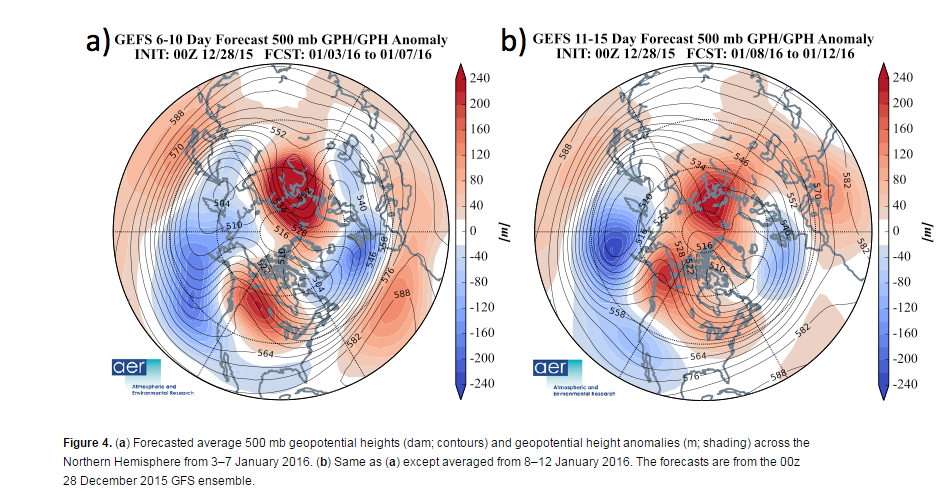
'The circulation pattern for the end of week two shows strong positive geopotential heights across northwest Eurasia and the Barents Kara Seas with downstream troughing over East Asia and the North Pacific with more troughing upstream in the eastern North Atlantic (Figure 4b). This is referred to the tripole pattern that we have shown is favorable for increasing the energy transfer or wave activity flux between the troposphere and the stratosphere (Cohen and Jones 2012). Furthermore the wave pattern is strikingly a wave two pattern that often results in increased energy transfer into the stratospheric polar vortex that results in polar vortex splits. Therefore we continue to anticipate further energy pulses beyond those predicted in Figure 7, ongoing perturbing and weakening of the polar vortex and eventually expect the polar vortex to split into two pieces.'
Bericht laatst bijgewerkt: 04-01-2016 10:34