We gaan weer verder met overstromingen en wateroverlast.
Stukje uit de verwachting:
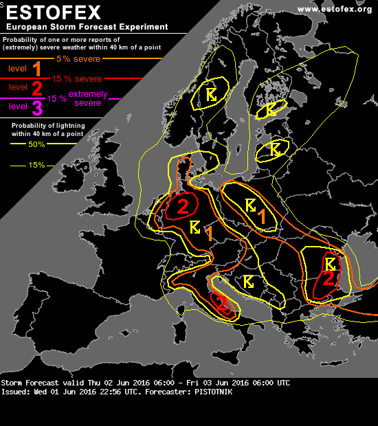
(1) N Germany:
Forecast models agree on the formation of a mesoscale low-pressure core, which shall move towards the Netherlands. Temporary warm air advection from the NE will allow the buildup of higher CAPE up to 1500 J/kg ahead of it and may establish slightly enhanced vertical wind shear. Aided by convergent low-level winds and a pronounced vorticity maximum aloft, widespread storms are expected and will possibly merge into one or two MCSs in the afternoon and evening.
Next to an enhanced risk of flash floods, also localized instances of 2-3 cm sized hail (mostly in an early stage, when storms are still discrete) and severe wind gusts (especially at the leading edge of an MCS) are possible. The regions with the expected highest coverage is upgraded to a level 2.
Storms will likely reach the Netherlands and Belgium in the evening while slowly weakening. Quote selectie
Stukje uit de verwachting:
(1) N Germany:
Forecast models agree on the formation of a mesoscale low-pressure core, which shall move towards the Netherlands. Temporary warm air advection from the NE will allow the buildup of higher CAPE up to 1500 J/kg ahead of it and may establish slightly enhanced vertical wind shear. Aided by convergent low-level winds and a pronounced vorticity maximum aloft, widespread storms are expected and will possibly merge into one or two MCSs in the afternoon and evening.
Next to an enhanced risk of flash floods, also localized instances of 2-3 cm sized hail (mostly in an early stage, when storms are still discrete) and severe wind gusts (especially at the leading edge of an MCS) are possible. The regions with the expected highest coverage is upgraded to a level 2.
Storms will likely reach the Netherlands and Belgium in the evening while slowly weakening. Quote selectie

 .
.