Storm Forecast
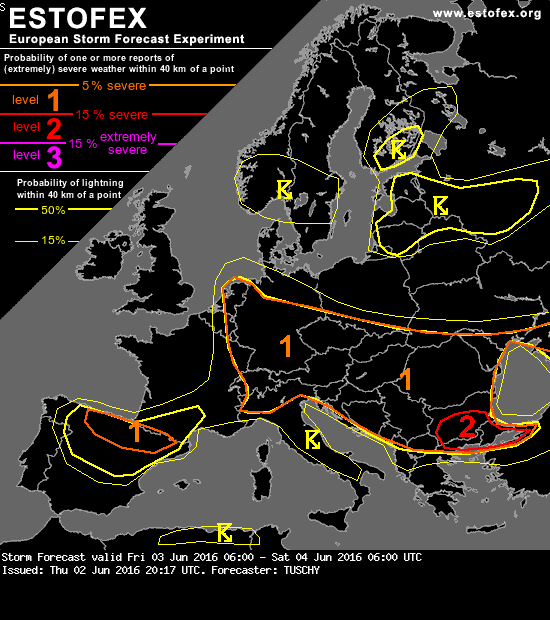
Valid: Fri 03 Jun 2016 06:00 to Sat 04 Jun 2016 06:00 UTC
Issued: Thu 02 Jun 2016 20:17
Forecaster: TUSCHY
A level 1 was issued from Romania to Benelux mainly for isolated large hail, excessive rain and a severe wind gust or two. (Noot: lol )
)
SYNOPSIS
Weak geopotential height gradients prevail over Europe. Longbreathed cyclonic circulation over CNTRL Europe weakens and moves towards Benelux. A stronger mid-level wave exits the Ionian Sea to the east and is accompanied by rather strong mid-level flow of up to 30 m/s at 500 hPa. An intense trough over N-Norway/Sweden rotates east/southeast while weakening a bit.
Regarding surface fronts, the main feature is an occlusion over N-Norway/Sweden which is pegged to the aforementioned trough and moves to the SE. Else no fronts - important for DMC initiation - are predicted.
DISCUSSION
... CNTRL - / E- Europe ...
Another day with widespread CI until sunset and a gradual downswing thereafter. DLS of less than 10 m/s and BL mixing ratios of 9-10 g/kg indicate an enhanced risk for slow moving effective rain producing showers/thunderstorms with a gradual upscale growth into numerous clusters. During initiation, isolated large hail (but mainly large amounts of small hail) and gusty winds are forecast. Betimes the risk transforms into an heavy rainfall risk with numerous flash flood events expected. The highest risk for excessive rain arises from S-Poland to Moldova with peak PPWs and backbuilding tendencies of storms. W-Germany experiences similar PPWs, but slow forward propagating storm vectors should keep probabilities for training storm activity on the lower end side.
Right now, no region with high confidence for extreme rainfall amounts can be detected and hence no level 2 was issued. Mesoscale boundaries and orography probably dictate that risk.
Valid: Fri 03 Jun 2016 06:00 to Sat 04 Jun 2016 06:00 UTC
Issued: Thu 02 Jun 2016 20:17
Forecaster: TUSCHY
A level 1 was issued from Romania to Benelux mainly for isolated large hail, excessive rain and a severe wind gust or two. (Noot: lol
)SYNOPSIS
Weak geopotential height gradients prevail over Europe. Longbreathed cyclonic circulation over CNTRL Europe weakens and moves towards Benelux. A stronger mid-level wave exits the Ionian Sea to the east and is accompanied by rather strong mid-level flow of up to 30 m/s at 500 hPa. An intense trough over N-Norway/Sweden rotates east/southeast while weakening a bit.
Regarding surface fronts, the main feature is an occlusion over N-Norway/Sweden which is pegged to the aforementioned trough and moves to the SE. Else no fronts - important for DMC initiation - are predicted.
DISCUSSION
... CNTRL - / E- Europe ...
Another day with widespread CI until sunset and a gradual downswing thereafter. DLS of less than 10 m/s and BL mixing ratios of 9-10 g/kg indicate an enhanced risk for slow moving effective rain producing showers/thunderstorms with a gradual upscale growth into numerous clusters. During initiation, isolated large hail (but mainly large amounts of small hail) and gusty winds are forecast. Betimes the risk transforms into an heavy rainfall risk with numerous flash flood events expected. The highest risk for excessive rain arises from S-Poland to Moldova with peak PPWs and backbuilding tendencies of storms. W-Germany experiences similar PPWs, but slow forward propagating storm vectors should keep probabilities for training storm activity on the lower end side.
Right now, no region with high confidence for extreme rainfall amounts can be detected and hence no level 2 was issued. Mesoscale boundaries and orography probably dictate that risk.
 Het went...