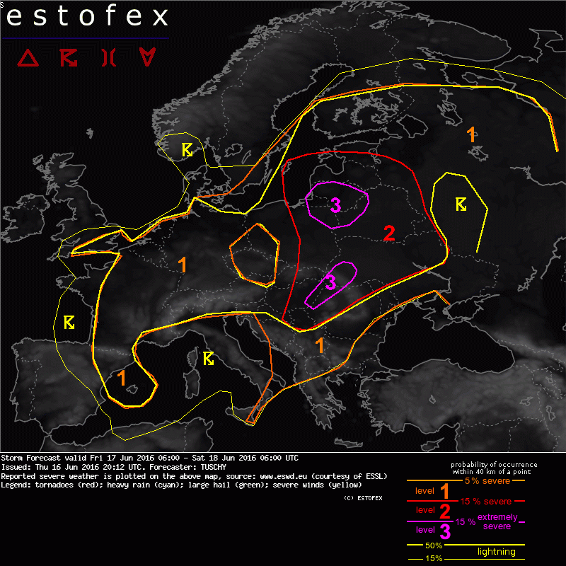
Zo het zou morgen wel eens helemaal los kunnen gaan in oost europa als ik estofex mag geloven, zie ook bijgevoegd kaartje.
Paar passages uit de tekst
Noordelijk lvl 3 gebied
Intense 30 m/s speed max at 700 hPa approaches this convection from the SW and a potential scenario will be a developing severe MCS, which races to the N/NE. Widespread severe/damaging wind gusts will be the main hazards, although expected shear will probably support a few tornado events as well. Large hail is also possible and combined with severe wind gusts, damaging wind-driven hail could be a life-threatening risk!
Zuidelijk lvl 3 gebied
Isolated to scattered thunderstorms erupt in an environment with 1-2 kJ/kg MLCAPE and MUCAPE peaks of more than 3000 J/kg! Very fat mid-level CAPE profiles overlap with 30 m/s 0-6 km shear. 25 m/s 0-3 km shear support well organized and long-lived supercells with a damaging hail threat (hail diameter in excess of 5 cm is likely). A deep and well mixed subcloud layer also assists in very intense downdrafts, which probably cause a few hurricane-force wind gust events - combined with the hail, life-threatening storms with high-end impact are possible.
Benieuwd wat voor beelden er gaan komen vanuit die hoek. Gevaarlijke situatiemet het snel uitdiepende laag.
In Nederland overigens lvl 1.
Paar passages uit de tekst
Noordelijk lvl 3 gebied
Intense 30 m/s speed max at 700 hPa approaches this convection from the SW and a potential scenario will be a developing severe MCS, which races to the N/NE. Widespread severe/damaging wind gusts will be the main hazards, although expected shear will probably support a few tornado events as well. Large hail is also possible and combined with severe wind gusts, damaging wind-driven hail could be a life-threatening risk!
Zuidelijk lvl 3 gebied
Isolated to scattered thunderstorms erupt in an environment with 1-2 kJ/kg MLCAPE and MUCAPE peaks of more than 3000 J/kg! Very fat mid-level CAPE profiles overlap with 30 m/s 0-6 km shear. 25 m/s 0-3 km shear support well organized and long-lived supercells with a damaging hail threat (hail diameter in excess of 5 cm is likely). A deep and well mixed subcloud layer also assists in very intense downdrafts, which probably cause a few hurricane-force wind gust events - combined with the hail, life-threatening storms with high-end impact are possible.
Benieuwd wat voor beelden er gaan komen vanuit die hoek. Gevaarlijke situatiemet het snel uitdiepende laag.
In Nederland overigens lvl 1.