Collega van me zit nu in Kaoshiung op schip. Dat wordt afzien, zelfs in de beschutting van de haven.
wdpn31 pgtw 072100
msgid/genadmin/joint typhoon wrncen Pearl Harbor hi//
subj/prognostic reasoning for super typhoon 02w (Nepartak)
warning nr 20//
rmks//
1. For meteorologists.
2. 6 hour summary and analysis.
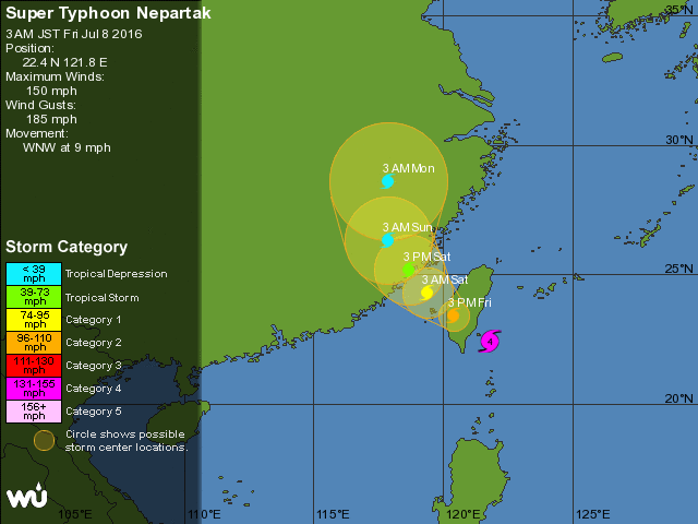
Super typhoon 02w (Nepartak), located approximately 163 nm south
of Taipei, Taiwan, has tracked west-northwestward at 08 knots
over the past six hours. The current position is based on satellite
eye fixes from pgtw and rjtd as well as radar imagery from Taiwan.
The satellite fixes are displaced to the west-northwest of the radar
fixes, which implies a slight tilt to the core of the circulation.
Intensity is estimated at 130 knots, consistent with subjective
Dvorak satellite intensity estimates from multiple agencies and with
recent objective satellite intensity consensus data. Sty 02w has
begun to gradually weaken as the topography of Taiwan begins to
inhibit the inflow on the western side of the low-level circulation.
The eye has begun to fill, and the eyewall is becoming increasingly
ragged in radar imagery. The system continues to track toward
southeast Taiwan under the influence of a deep-layered subtropical
steering ridge.
3. Forecast reasoning.
A. No change to the forecast philosophy since the previous
prognostic reasoning message.
B. Sty 02w will continue tracking generally west-northwestward
along the periphery of the subtropical ridge to the northeast until
it makes landfall in southeast Taiwan around tau 06. In the near
term, gradual weakening is expected, but sty 02w is expected to
remain at or near super typhoon intensity at landfall, followed by
more rapid weakening as the low-level circulation center (LLCC) gets
disrupted by the Central Mountain range of eastern Taiwan. The LLCC
may become decoupled from the mid-level circulation as the system
crosses the Central Mountain range in a perpendicular direction.
Some reorganization is possible as sty 02w crosses the Taiwan
Strait. By tau 36, sty 02w will have moved into southeastern China,
with dissipation expected by tau 72. Numerical model guidance is in
good agreement through the forecast period, lending high confidence
to the jtwc track forecast./=
wdpn31 pgtw 072100
msgid/genadmin/joint typhoon wrncen Pearl Harbor hi//
subj/prognostic reasoning for super typhoon 02w (Nepartak)
warning nr 20//
rmks//
1. For meteorologists.
2. 6 hour summary and analysis.
Super typhoon 02w (Nepartak), located approximately 163 nm south
of Taipei, Taiwan, has tracked west-northwestward at 08 knots
over the past six hours. The current position is based on satellite
eye fixes from pgtw and rjtd as well as radar imagery from Taiwan.
The satellite fixes are displaced to the west-northwest of the radar
fixes, which implies a slight tilt to the core of the circulation.
Intensity is estimated at 130 knots, consistent with subjective
Dvorak satellite intensity estimates from multiple agencies and with
recent objective satellite intensity consensus data. Sty 02w has
begun to gradually weaken as the topography of Taiwan begins to
inhibit the inflow on the western side of the low-level circulation.
The eye has begun to fill, and the eyewall is becoming increasingly
ragged in radar imagery. The system continues to track toward
southeast Taiwan under the influence of a deep-layered subtropical
steering ridge.
3. Forecast reasoning.
A. No change to the forecast philosophy since the previous
prognostic reasoning message.
B. Sty 02w will continue tracking generally west-northwestward
along the periphery of the subtropical ridge to the northeast until
it makes landfall in southeast Taiwan around tau 06. In the near
term, gradual weakening is expected, but sty 02w is expected to
remain at or near super typhoon intensity at landfall, followed by
more rapid weakening as the low-level circulation center (LLCC) gets
disrupted by the Central Mountain range of eastern Taiwan. The LLCC
may become decoupled from the mid-level circulation as the system
crosses the Central Mountain range in a perpendicular direction.
Some reorganization is possible as sty 02w crosses the Taiwan
Strait. By tau 36, sty 02w will have moved into southeastern China,
with dissipation expected by tau 72. Numerical model guidance is in
good agreement through the forecast period, lending high confidence
to the jtwc track forecast./=