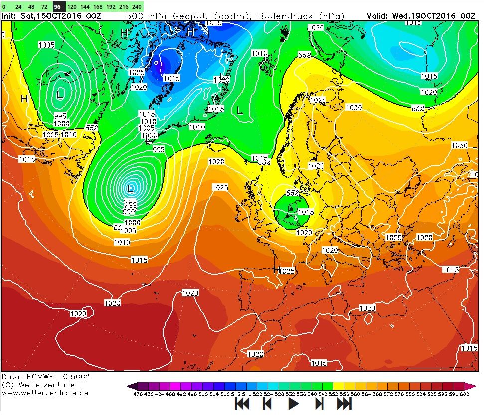
Je ziet het wel meer dat tropische orkanen in een weststroming opgenomen worden.
In hoeverre ze ons weer bepalen is me niet altijd duidelijk, gisteren werd hier geschreven dat Nicole het Scandi-hoog positief beïnvloedt. Helemaal zeker ben ik daar niet van, Nicole kan ook gewoon afgeleid worden naar het noorden door het Scandi.
Mijn punt is dat het soms een kip- en eiverhaal is. Er zal altijd wel een beetje invloed zijn maar de mate waarin is onzeker.
Zuidelijker gelegen cyclonen die lang tropische kenmerken hebben lijken mij meer invloed te hebben op ons weer.
Dat komt vooral vanwege de enorme warmteadvectie, goed te zien op onderstaande kaart.
Daar zie je de rug ontstaan die fuseert met de Rus.
Wat ik overigens wel opvallend vind aan Nicole is dat ze zo lang de tropische eigenschappen vast houdt. Dat is op de breedte wel ongebruikelijk, gezien de lage zeewatertemps en de sterke windschering die hier heerst.
Zie ook de forecast van het NHC:
Tropical Storm NICOLE Forecast Discussion
Home Public Adv Fcst Adv Discussion Wind Probs Graphics Archive
000
WTNT45 KNHC 150834
TCDAT5
TROPICAL STORM NICOLE DISCUSSION NUMBER 45
NWS NATIONAL HURRICANE CENTER MIAMI FL AL152016
500 AM AST SAT OCT 15 2016
The cloud pattern has not changed much since the last advisory. Patches of deep convection keep reforming near and to the north of the center. The circulation appears to be elongated, but it is still well defined. Initial intensity is kept at 60 kt.
As mentioned by my predecessor, the future structure of Nicole is difficult to forecast. Given the strong shear and cold SSTs, one should tend to foreast weakening or extratropical transition. However, both the GFS and the ECMWF simulated infrared imagery continue to forecast the development of an eye feature in a day or so. Given these model solutions, the NHC forecast keeps Nicole with tropical characteristics during the next 3 days and calls for the cyclone to become post-tropical thereafter.