paar actieve systemen boven de oceaan- potentiele orkanen?
Bericht van: Dirk18 (Hengelo) , 21-08-2003 21:06
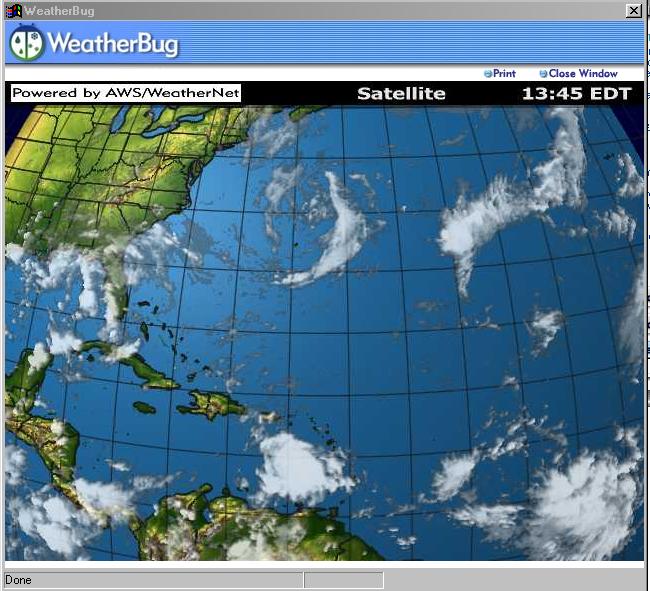
Mijn amerikaanse programmaatje 'weatherbug' beschouwt de kans op nieuwe orkanen:
Tropics Head Into Peak Season
8AM EDT, August 21, 2003
By Chief WeatherBug Meteorologist, Mark Hoekzema
Several areas of thunderstorms over the tropical Atlantic and Gulf of Mexico deserve watching over the next several days, but one or two stand out as deserving more attention.
A tropical wave that crossed the Windward Islands into the Caribbean on Wednesday has shown a tendency to pulse in activity. The last several evenings, activity has diminished after storm bubbled through the day. This weakening is despite the fact it has a weak, broad circulation.
This tropical wave continues to move through an area that would be favorable for development and forecasters are watching it closely. An Air Force hurricane hunter will investigate the area later today if the storm shows more organization.
Looking further out at the long term motion, this system will continue to track west-northwest and the current speed would put any developing system in the northwestern Caribbean late in the weekend.
Another area that appears active is a tropical wave halfway between Africa and the Windward Islands. This system has shown very strong complexes of thunderstorms at times. Extended forecast models actually develop this system into a storm early next week and have it moving towards the Bahamas late in the week.
The extended forecasts for the locations of these systems are very difficult to determine because if the systems weaken or strengthen, they could move at entirely different speeds and directions.
Another area of showers and storms is located along the Gulf Coast and across Florida. This area is very disorganized and non-tropical. It is not likely that anything will develop from this area of instability along the coast.
Tropical activity so far in the 2003 has been high and all the activity so far has occurred before the period of peak tropical weather. The Atlantic is entering the peak days for tropical activity with the highest percentage of storms occurring between late August and early October.
Tracking tropical activity becomes critical over the next two months. Use your WeatherBug to keep you posted on the tropical weather by looking for tropical updates and visiting HurricaneNet.
Weatherbug is overigens een erg geinig programmaatje, dat ik op raadselachtige wijze op mijn computer heb gekregen. Onderdeel ervan is een cijfertje in de taakbalk dat altijd de actuele temperatuur in New York aangeeft (bij dubbelklikken ook alle andere gegevens)
Tropics Head Into Peak Season
8AM EDT, August 21, 2003
By Chief WeatherBug Meteorologist, Mark Hoekzema
Several areas of thunderstorms over the tropical Atlantic and Gulf of Mexico deserve watching over the next several days, but one or two stand out as deserving more attention.
A tropical wave that crossed the Windward Islands into the Caribbean on Wednesday has shown a tendency to pulse in activity. The last several evenings, activity has diminished after storm bubbled through the day. This weakening is despite the fact it has a weak, broad circulation.
This tropical wave continues to move through an area that would be favorable for development and forecasters are watching it closely. An Air Force hurricane hunter will investigate the area later today if the storm shows more organization.
Looking further out at the long term motion, this system will continue to track west-northwest and the current speed would put any developing system in the northwestern Caribbean late in the weekend.
Another area that appears active is a tropical wave halfway between Africa and the Windward Islands. This system has shown very strong complexes of thunderstorms at times. Extended forecast models actually develop this system into a storm early next week and have it moving towards the Bahamas late in the week.
The extended forecasts for the locations of these systems are very difficult to determine because if the systems weaken or strengthen, they could move at entirely different speeds and directions.
Another area of showers and storms is located along the Gulf Coast and across Florida. This area is very disorganized and non-tropical. It is not likely that anything will develop from this area of instability along the coast.
Tropical activity so far in the 2003 has been high and all the activity so far has occurred before the period of peak tropical weather. The Atlantic is entering the peak days for tropical activity with the highest percentage of storms occurring between late August and early October.
Tracking tropical activity becomes critical over the next two months. Use your WeatherBug to keep you posted on the tropical weather by looking for tropical updates and visiting HurricaneNet.
Weatherbug is overigens een erg geinig programmaatje, dat ik op raadselachtige wijze op mijn computer heb gekregen. Onderdeel ervan is een cijfertje in de taakbalk dat altijd de actuele temperatuur in New York aangeeft (bij dubbelklikken ook alle andere gegevens)