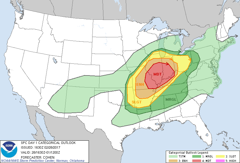
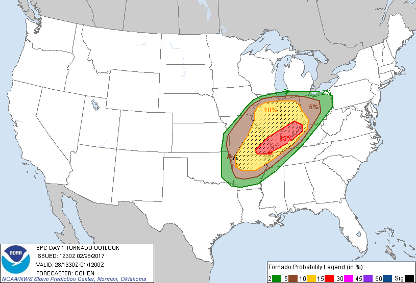
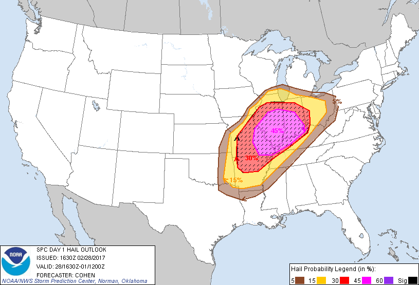
Het SPC heeft een moderate risk uitgegeven vandaag vanwege kans op significante tornado's en hagel. Vooral het zuiden van Illinois en Indiana liggen in het gebied met de grootste overlap en hebben dus de grootste kans op zware onweders later vandaag. Bijgevoegd enkele plaatjes van het SPC met de kansen in % en hun guidance in het Engels.
Links naar chasers of interessante radarbeelden graag in deze draad!
...SUMMARY...
Severe thunderstorms are expected to develop from portions of the
lower Mississippi Valley to the Ohio Valley through tonight. Strong
tornadoes will be possible, especially across portions of the lower
and middle Ohio Valley. Otherwise, large hail and damaging winds are
expected.
...Portions of the MO Ozarks through the middle MS Valley and the
Ohio Valley region...
A prominent warm sector will continue to build
northward/northeastward across the region through tonight, as a
midlevel speed maximum advances from the southern Rockies
east-northeastward toward the Ohio Valley region. As lower/middle
60s dewpoints also develop northward/northeastward, an expansive
area of MLCAPE around 500-2000 J/kg -- aided by steep midlevel lapse
rates surmounting returning moisture -- will support vigorous
convective development. With warm-sector-coinciding effective shear
around 40-70 kt, a widespread area of conditional significant-severe
potential will exist -- especially from late afternoon into the
overnight hours. Present indications are that clusters of storms
will be evolving from eastern parts of the central/southern Great
Plains northeastward to the vicinity of southern Lake Michigan by
late afternoon/early evening in the vicinity of a baroclinic band --
with this activity spreading eastward into tonight. Confidence has
increased in more widespread severe-hail potential with this
activity, including significant severe hail. Open-warm-sector
convection will likely evolve along a low-level jet through parts of
the Ohio Valley tonight as additional moistening occurs. Effective
SRH of 300-400 m2/s2 will support tornado potential with evolving
supercell clusters. This includes the potential for nocturnal
significant tornadoes, and tornado probabilities have been
increased.
Links naar chasers of interessante radarbeelden graag in deze draad!
...SUMMARY...
Severe thunderstorms are expected to develop from portions of the
lower Mississippi Valley to the Ohio Valley through tonight. Strong
tornadoes will be possible, especially across portions of the lower
and middle Ohio Valley. Otherwise, large hail and damaging winds are
expected.
...Portions of the MO Ozarks through the middle MS Valley and the
Ohio Valley region...
A prominent warm sector will continue to build
northward/northeastward across the region through tonight, as a
midlevel speed maximum advances from the southern Rockies
east-northeastward toward the Ohio Valley region. As lower/middle
60s dewpoints also develop northward/northeastward, an expansive
area of MLCAPE around 500-2000 J/kg -- aided by steep midlevel lapse
rates surmounting returning moisture -- will support vigorous
convective development. With warm-sector-coinciding effective shear
around 40-70 kt, a widespread area of conditional significant-severe
potential will exist -- especially from late afternoon into the
overnight hours. Present indications are that clusters of storms
will be evolving from eastern parts of the central/southern Great
Plains northeastward to the vicinity of southern Lake Michigan by
late afternoon/early evening in the vicinity of a baroclinic band --
with this activity spreading eastward into tonight. Confidence has
increased in more widespread severe-hail potential with this
activity, including significant severe hail. Open-warm-sector
convection will likely evolve along a low-level jet through parts of
the Ohio Valley tonight as additional moistening occurs. Effective
SRH of 300-400 m2/s2 will support tornado potential with evolving
supercell clusters. This includes the potential for nocturnal
significant tornadoes, and tornado probabilities have been
increased.