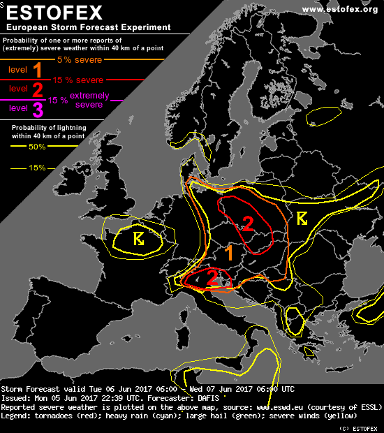
Estofex verwacht geen bijzonderheden voor NL
Bericht van: Jan Willem (Etten, GLD) , 06-06-2017 07:21Storm Forecast
Valid: Tue 06 Jun 2017 06:00 to Wed 07 Jun 2017 06:00 UTC
Issued: Mon 05 Jun 2017 22:39
Forecaster: DAFIS
A level 2 was issued for parts of Poland, E Germany, Czech Republic, Slovakia and N Hungary mainly for excessive precipitation, large hail, severe wind gusts and tornadoes.
A level 2 was issued for N Italy, S Slovenia and NW Croatia mainly for large hail, excessive precipitation, severe wind gusts and an isolated tornado event.
A level 1 covers a large part of Central Europe for the same threats with less coverage probability.
SYNOPSIS
A negative-tilted long-wave trough is expected to cross France until the early morning of Tuesday, followed by a strong tropopause folding with a dry slot. This feature is associated with a strong depression near the surface over the UK, gradually deepening to 988 hPa with a pronounced baroclinic zone moving east towards Central Europe. Phase diagrams suggest a transformation towards a shallow warm-core vortex as an occlusion is about to be wrapped around. Two main front zones will be of our main interest: the warm front of the over Poland and the following fast-moving cold front that is now found in NW France (2200z).
Over Central Mediterranean a cut-off low travels east providing lift to already unstable air masses, and another cut-off low over Turkey gradually vanishes while moving NE, but before it disappears, it will create a favorable environment, along with LL WAA in SW Russia, for MCSs and supercells, just outside our domain.