Zie hier.
http://www.aer.com/science-research/climate-weather/arctic-oscillation
Eurasian snow cover extent will finish above normal for the month of October. It started the month with well above normal snow cover extent (SCE) but then had a fairly unusual stall where the snow cover extent nearly didn’t advance for two whole weeks. This was an unprecedented event in recent Octobers. However, in the third week of October the snow cover extent picked up once again and October 2017 SCE will easily be above normal and given how the month began was never really in doubt.
Besides SCE an alternative snow index that I have proposed and utilize in subseasonal to seasonal forecasts is the snow advance index (SAI). The SAI does not measure the areal extent of snow cover but rather the rate at which the snow cover advances over the course of the month and the area measured is limited to equatorward or south of 60°N. A relatively rapid advance of snow cover would be comparable to extensive snow cover and an indication for a weak polar vortex (PV), a negative AO first in the stratosphere followed by a negative AO in the troposphere and relatively cold weather across the Northern Hemisphere (NH) mid-latitudes. Given the long stall in snow cover advance in mid-October, the SAI will likely be negative this October. This is a forecast of a strong PV, a positive AO in both the stratosphere and troposphere and a relatively mild winter across the NH.
The SAI index is in contrast to the SCE index that indicates just the opposite. This is a similar situation to 2013 when the SCE was strongly positive and the SAI was negative. This adds complexity and decreases my confidence in the winter forecast. I have come to believe that the SAI is most useful as an indicator of the timing of when we might expect a weakening the stratospheric PV. When the SAI is positive then we can expect a stratospheric PV weakening earlier in the season and when the SAI is negative then we can expect any weakening of the stratospheric PV to take place later in the season. In 2009 and 2016 when the highest SAI values have been observed since daily snow cover extent has been available, stratospheric PV weakenings were observed even before the winter began with an unprecedently early PV split observed at the end of October and early November last year. There are so far no signs of a robust stratospheric PV weakening and indications are even for a relatively strong stratospheric PV for much of the month of November. Similarly in fall and early winter 2013/14 the stratospheric PV was strong but eventually troposphere-stratosphere coupling became active that did not result in a strong PV weakening (no major mid-winter warmings were observed that winter) but did stretch or repeatedly elongated the stratospheric PV that contributed to a cold winter in the Eastern US.
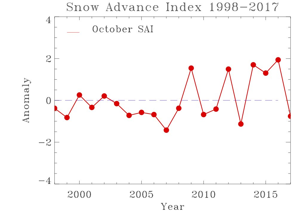
Een hoge SAI is duidelijk geen garantie voor een koude winter. Ook de draken van 2015 en 2016 werden vooraf gegaan door een hoge SAI waarde. Vooraf aan 2010 en 2013 ook een hoge SAI waarde.