Huidige kerndruk is 995 hPa met sustained windsnelheden van 100 km/h en windstoten tot 125 km/h. De nieuwe verwachting is iets heviger dan de verwachting van gisteravond. Een minimale kerndruk van 986 hPa staat nu op Estofex met sustained windsnelheden van 125 km/h met windstoten tot 160 km/h. Ook als de medicane aan land komt/over de eilanden trekt bij Griekenland zijn de sustained windsnelheden nog steeds van orkaankracht.
Volgens de EC & GFS modellen is de temperatuur van de huidige stormkern zo'n 23 à 24 graden Celsius. Dit betekent dat de storm een relatief warme kern heeft en dus geen extratropische storm is (gekenmerkt door een koudere kern tov de omliggende gebieden en hoge temperatuursverschillen in het centrum). Tropische stormen vormen normaliter pas bij 26,5 graden Celsius dus dat is deze storm ook niet. Als je die 2 opties wegstreept, blijft een subtropische storm over, wat een beetje tussen een extratropische en een tropische storm in zit. Echter, Nhc houdt de regel aan dat een subtropische storm die sustained windsnelheden van 120 km/h haalt officieel een (tropische) orkaan is, onafhankelijk van de zeetemperatuur of breedtegraad. Natuurlijk valt deze storm niet onder Nhc dus het is nog allemaal onduidelijk wat deze storm nou wel of niet is/wordt, behalve dat het meer is dan een simpele extratropische storm. Er zijn ook weer enkele bronnen die helemaal niet kijken naar zeetemperatuur/windsnelheden en de benaming alleen baseren op de locatie waar de storm ontstaat. In dat geval zou dit ook een subtropische storm zijn, onafhankelijk van de windsnelheid en zeetemperatuur. Als het aan mij zou liggen, gooien we al die onduidelijke regels uit het raam en noemen we alle stormen die bij warme zeetemperaturen in de Middellandse Zee ontstaan gewoon een medicane. Gewoon een benamingsverschil, net zoals je ook orkanen & typhonen hebt. Medicane is een term die vaak wordt gebruikt, maar volgens mij nog niet officieel gebruikt wordt. Maar ja, er is eigenlijk ook nog geen officieel weercentrum dat kijkt naar stormen in de Middellandse Zee dus bijna alles is nog 'onofficieel'.
Hieronder het hele bericht van Estofex:
Mesoscale Discussion
Valid: Fri 28 Sep 2018 09:00 to Fri 28 Sep 2018 21:00 UTC
Issued: Fri 28 Sep 2018 09:01
Forecaster: ESTOFEX
This is a Mesoscale Discussions issued for a cyclone that is primarily driven by convection, issued twice daily before 9, and 21 UTC until the cyclone dissipates or becomes extratropical. This Mesocale Discussion is not an official producat and does not substitute any warnings from National Meteorological Services. We welcome any feedback at inflow@estofex.org.
System: 2018M02
At 28 SEP 0600UTC the storm centre was located near 34.8N and 18.7E
Estimated minimum pressure: 995 mb.
Maximum sustained winds: 28 m/s (55 kt, 100 km/h).
Maximum gusts: 35 m/s (70 kt, 125 km/h).
ANALYSIS
Overnight, the cyclone has organized and deepened, while drifting northward. Cloud bands are spiralling around the intensified vortex, although a tight inner circulation has not (yet) developed. A subjective Hebert-Poteat technique estimate yields T numbers between 3.0 and 3.5 at 06 UTC, supporting a minimum pressure of near 995 mb and maximum sustained winds near 28 m/s.
FORECAST
Models are in agreement that the cyclone should move only very slowly during the next 12 hours, before accelerating east-northeastward towards the Peloponnese, as an upper left trough approaches from the northwest. The greastest uncertainty in the forecast is the extent of interaction with the mountainous region of the Peloponnese: ICON and UKMO predicting the greatest interaction and strongest weakening, whereas ECMWF and ARPEGE continue feature a more southerly track with less influence on the inner core. The new track and intensity forecast are a blend of these different solutions. The track has been adjusted slightly to the south, and is quicker after 36 hours. The forecast takes the cyclone into Northwestern Anatolia on Sunday evening, upon which the cyclone will weaken rapidly.
The cyclone is predicted to intensify somewhat more prior to landfall the Peloponnese as suggsted by UKMO and ARPEGE, before moderate weakening occurs. As said, the intensity forecast after 36 hours is strongly dependent on the level of interaction with terrain and therefore rather uncertain.
The primary hazard of the cyclone is expected to be very heavy precipitation. Amounts of 200-300 mm can be expected on Saturday and Sunday across the Peloponnese, 125-250 mm over Attica, Eastern Central Greece (including Euboia) and the Cyclades, and 50–125 mm over southern Crete, Western Anatolia, the North Aegean Islands and Dodecanese Islands. In addition, isolated hurricane force winds and widespread hurricane force gusts will likely affect the southern Peloponnese coasts and the Cyclades.
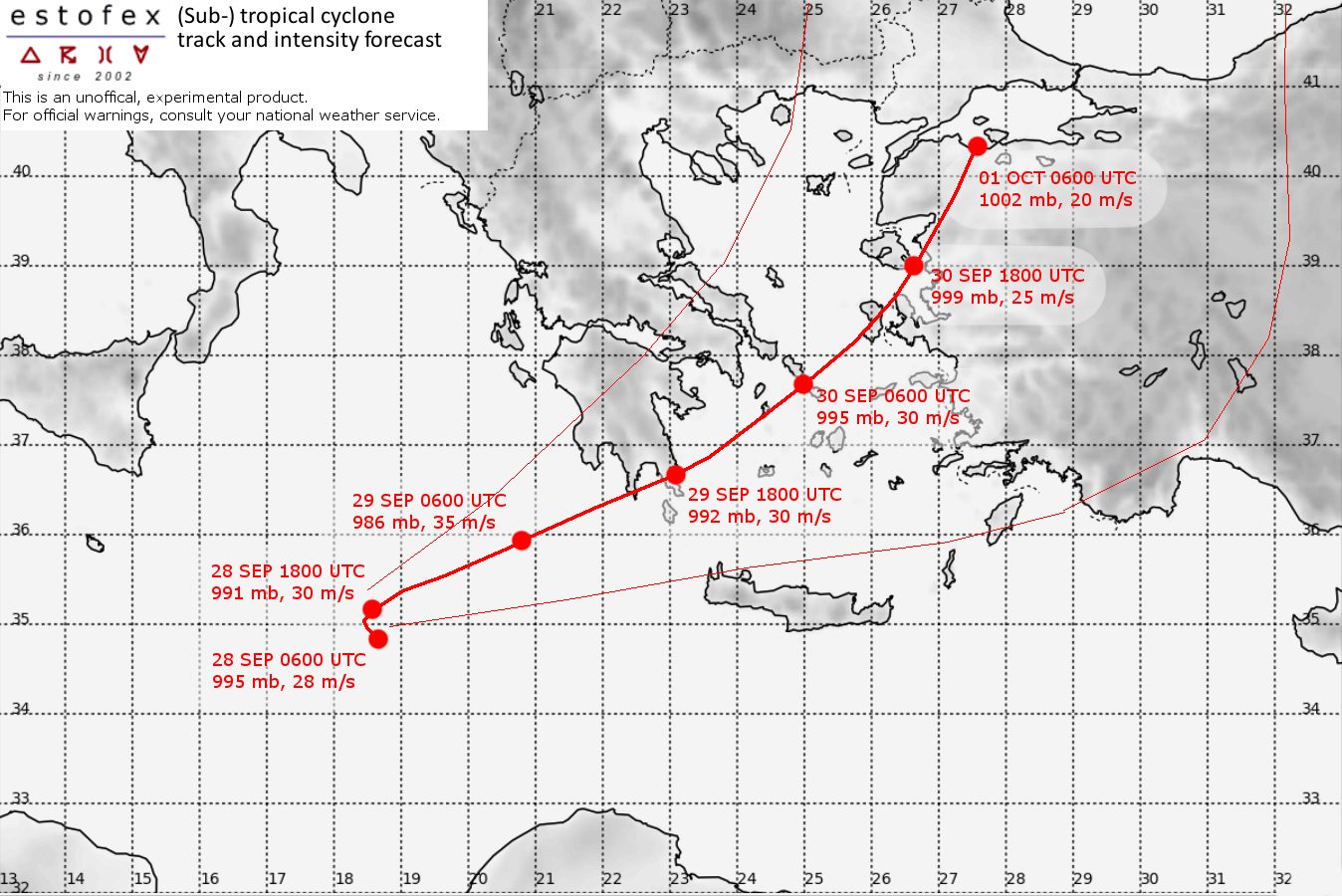
Forecast:
FH DATE & TIME LOCATION PRESSURE WIND MAX.GUSTS
00 28SEP 0600 UTC 34.8N 18.7E 995 mb 28 m/s 35 m/s
12 28SEP 1800 UTC 35.2N 18.6E 991 mb 30 m/s 40 m/s
24 29SEP 0600 UTC 35.9N 20.8E 986 mb 35 m/s 45 m/s
36 29SEP 1800 UTC 36.7N 23.1E 992 mb 30 m/s 40 m/s NEAR COAST
48 30SEP 0600 UTC 37.7N 25.0E 997 mb 30 m/s 40 m/s
60 30SEP 1800 UTC 39.0N 26.7E 999 mb 25 m/s 30 m/s AT COAST
72 01OCT 0600 UTC 38.8N 27.2E 1002 mb 20 m/s 25 m/s INLAND