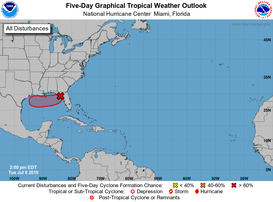
Aparte trekrichting van vlak lagedrukgebied wat tropische aspiraties krijgt. Doorgaans gaan dergelijke systemen toch met de klok mee om Atlantische hoog? Boeiend, want potentie voor de nodige impact volgens de NHCC.
ZCZC MIATWOAT ALL
TTAA00 KNHC DDHHMM

Tropical Weather Outlook
NWS National Hurricane Center Miami FL
200 PM EDT Tue Jul 9 2019

For the North Atlantic...Caribbean Sea and the Gulf of Mexico:

1. A broad low pressure area has emerged over Apalachee Bay in the
northeastern Gulf of Mexico. Environmental conditions are expected
to be conducive for tropical cyclone formation and development
over the next several days, and a tropical depression is likely to
form by late Wednesday or Thursday while the system moves westward
across the northern Gulf of Mexico.  An Air Force Reserve Unit
reconnaissance aircraft is scheduled to investigate the low on
Wednesday, if necessary. This disturbance has the potential to
produce heavy rainfall from the Upper Texas Coast to the Florida
Panhandle during the next several days. In addition, this system
could produce wind and storm surge impacts later this week or this
weekend from Louisiana to the Upper Texas coast, and interests along
the Gulf Coast should continue to monitor its progress. For more
information, please see products issued by your local weather
forecast office and the NOAA Weather Prediction Center.
* Formation chance through 48 hours...high...70 percent.
* Formation chance through 5 days...high...80 percent.