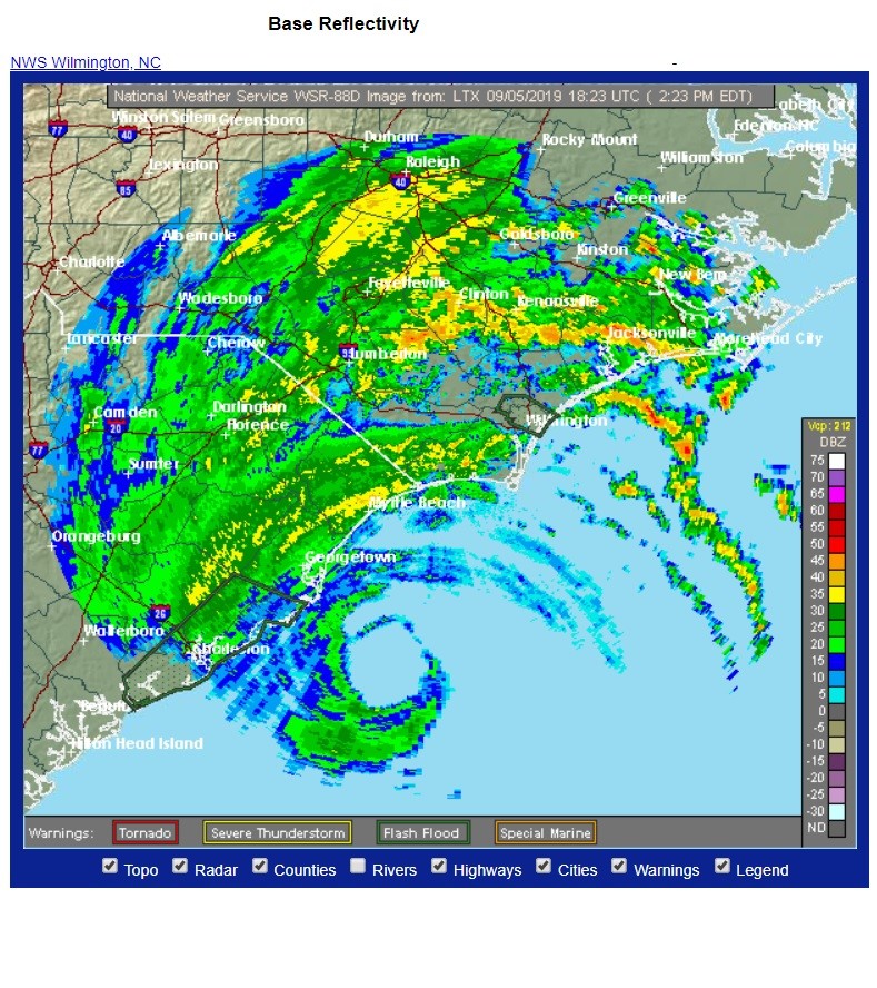
Inmiddels is hij zo dicht bij de kust gekomen dat er in de Carolina's orkaancondities gemeten worden. Ook zijn er tornado's in supercells in de buitenste neerslagbanden geweest.
Op de radar van Wilmington is hij goed te volgen:
https://radar.weather.gov/radar.php?rid=ltx&product=N0R&overlay=11101111&loop=no
Laatste advisory van het NHC:
000
WTNT35 KNHC 051751
TCPAT5

BULLETIN
Hurricane Dorian Intermediate Advisory Number 49A
NWS National Hurricane Center Miami FL       AL052019
200 PM EDT Thu Sep 05 2019

...EYE OF DORIAN JUST OFFSHORE OF CAPE ROMAIN SOUTH CAROLINA...


SUMMARY OF 200 PM EDT...1800 UTC...INFORMATION
----------------------------------------------
LOCATION...32.8N 78.9W
ABOUT 60 MI...95 KM S OF MYRTLE BEACH SOUTH CAROLINA
ABOUT 115 MI...185 KM SSW OF WILMINGTON NORTH CAROLINA
MAXIMUM SUSTAINED WINDS...110 MPH...175 KM/H
PRESENT MOVEMENT...NNE OR 25 DEGREES AT 8 MPH...13 KM/H
MINIMUM CENTRAL PRESSURE...958 MB...28.29 INCHES


WATCHES AND WARNINGS
--------------------
CHANGES WITH THIS ADVISORY:

The Tropical Storm Warning has been discontinued for the coast of
Georgia.

The Storm Surge Warning has been discontinued south of South Santee
River, South Carolina.

SUMMARY OF WATCHES AND WARNINGS IN EFFECT:

A Storm Surge Warning is in effect for...
* South Santee River SC to Poquoson VA
* Pamlico and Albemarle Sounds
* Neuse and Pamlico Rivers
* Hampton Roads

A Hurricane Warning is in effect for...
* Savannah River to the North Carolina/Virginia border
* Pamlico and Albemarle Sounds

A Tropical Storm Warning is in effect for...
* North Carolina/Virginia border to Fenwick Island DE
* Chesapeake Bay from Drum Point southward
* Tidal Potomac south of Cobb Island

A Tropical Storm Watch is in effect for...
* Woods Hole to Sagamore Beach MA
* Nantucket and Martha's Vineyard MA

A Storm Surge Warning means there is a danger of life-threatening
inundation, from rising water moving inland from the coastline,
during the next 36 hours in the indicated locations. For a depiction
of areas at risk, please see the National Weather Service Storm
Surge Watch/Warning Graphic, available at hurricanes.gov.  This is a
life-threatening situation.  Persons located within these areas
should take all necessary actions to protect life and property from
rising water and the potential for other dangerous conditions.
Promptly follow evacuation and other instructions from local
officials.

A Hurricane Warning means that hurricane conditions are expected
somewhere within the warning area.  Preparations to protect life and
property should be rushed to completion.

A Tropical Storm Warning means that tropical storm conditions are
expected within the warning area within 36 hours.

A Tropical Storm Watch means that tropical storm conditions are
possible within the watch area, generally within 48 hours.

Interests elsewhere along the Mid-Atlantic and New England coasts of
the United States, and Atlantic Canada, should continue to monitor
the progress of Dorian.

For storm information specific to your area, including possible
inland watches and warnings, please monitor products issued by your
local National Weather Service forecast office.


DISCUSSION AND OUTLOOK
----------------------
At 200 PM EDT (1800 UTC), the center of Hurricane Dorian was located
near latitude 32.8 North, longitude 78.9 West.  Dorian is moving
toward the north-northeast near 8 mph (13 km/h).  A turn toward the
northeast is anticipated by tonight, and a northeastward motion at a
faster forward speed is forecast on Friday.  On the forecast track,
the center of Dorian will continue to move close to the coast of
South Carolina this afternoon, and then move near or over the coast
of North Carolina tonight and Friday.  The center should move to the
southeast of extreme southeastern New England Friday night and
Saturday morning, and approach Nova Scotia later on Saturday.

Reports from an Air Force Reserve Hurricane Hunter aircraft indicate
that maximum sustained winds are near 110 mph (175 km/h) with higher
gusts.  Slow weakening is expected during the next few days.
However, Dorian is expected to remain a powerful hurricane as the
center moves near the coasts of South and North Carolina.

Hurricane-force winds extend outward up to 60 miles (95 km) from
the center and tropical-storm-force winds extend outward up to 195
miles (315 km).  The Weatherflow station at Winyah Bay, South
Carolina, recently reported sustained winds of 77 mph (124 km/h) and
a wind gust of 85 mph (137 km/h).  A buoy operated by the Coastal
Ocean Research and Monitoring Program 15 miles northeast of the
entrance to Charleston Harbor recently reported a wind gust of
92 mph (148 km/h).

The minimum central pressure based on Hurricane Hunter aircraft and
buoy data is 958 mb (28.29 inches).  NOAA buoy 41004 reported a
minimum pressure of 959.4 mb (28.33 inches) as the eye passed over
it.
https://www.nhc.noaa.gov/text/refresh/MIATCPAT5+shtml/051751.shtml

Bericht laatst bijgewerkt: 05-09-2019 20:34