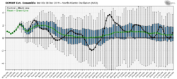
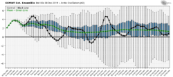
Het gemiddelde ligt bij zowel AO als NAO positief voor de hele periode.
Van de Netweather weerman:
I think, if you’ve not already, that we will have to lower expectations for January re: cold and snow, history indicates that once a strong +AO along with +NAO sets in by the New Year, it could last for the rest of the winter. We only have to look at real stinkers of winters for cold and snow with +AO/+NAO most of the winter to be worried: to name a few 2013/2014; 2007/2008; 1999/2000; 1997/1998; 1989/1990; 1988/1989. Once the +AO/+NAO combo sets in, the models generally tend to perform better over longer time frames than when these indices are negative.
Although the MJO briefly orbits through 7-8, it does so at low amplitude, so will likely have little effect on changing the wavelengths over the N Atlantic, furthermore there is strong support for the MJO to swiftly die into COD then emerge into the Maritime Continent, phases 4-5, which are warm phases, so there will likely be no help from the MJO through much of January. Though it is possible that the MJO will progress onwards to colder phases by mid-January – but the lag of this probably not having an effect until towards end of the month.
The AO flipped suddenly from -2 to +3 in a space of a few days recently in December, so I suppose there’s chance that it may flip back –ve later in January or February – though it’s not quite clear what the precursor for this would be. But there is also every likelihood that it could remain +ve through much of the rest of the winter. The QBO has only recently turned easterly, so unlikely this will have an impact on the PV until later in winter, when the PV would normally start to wane anyway. So we are kind of reliant on tropical forcing over the Pacific changing the patterns at high latitudes, of which there is unlikely to be much help from for a few weeks at least. There is EAMT and GLAAM to consider, but that’s not my forte, so cannot really suggest if these will have positive impacts.