https://www.severe-weather.eu/global-weather/enso-cold-phase-impact-hurricane-winter-fa/
Speculatief erbij gezet, omdat niet iedereen van LT houdt.
The global weather system is constantly in motion. It is always trying to reach a global balance, or equilibrium, which it can never achieve. One such attempt of global balance is starting to appear in the eastern tropical Pacific Ocean (ENSO), where an ocean surface cooling trend is starting to appear. It indicates a regime shift in the coming months, as a La Nina event is likely to unfold by Autumn 2020.
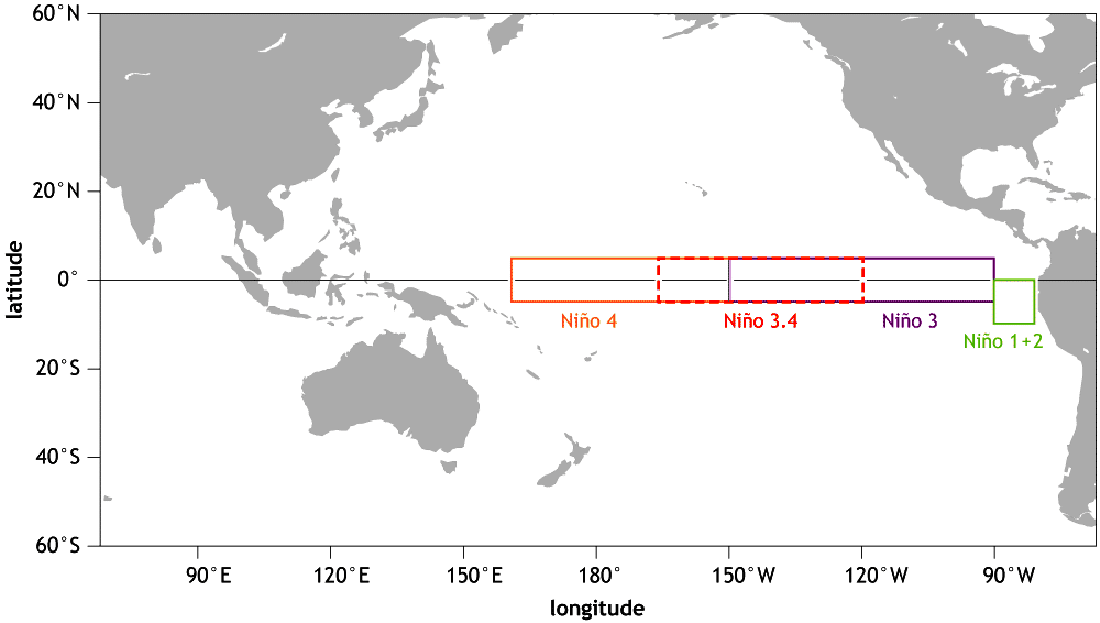
We already posted a global ocean analysis and impacts article about a month ago, outlining the 3 important oceanic areas to watch closely. One area was the ENSO (El Niño Southern Oscillation) region in the tropical Pacific Ocean. This is probably the most famous oceanic area in the world, as far as global weather impacts go. ENSO phases are well known to have an important impact on weather and climate almost worldwide. The image below shows the area of the Pacific Ocean, where the ENSO regions are found. There are a total of 4 ENSO regions. The main one, that we look at to determine/calculate phases, is the ENSO 3.4 region, which covers both the region 3 and 4, hence the name “ENSO 3.4”.
What is “ENSO”?
ENSO is short for “El Niño Southern Oscillation”. There are many ways to describe it, but the best version is probably from the NOAA Climate page:
“El Niño and La Niña are the warm and cool phases of a recurring climate pattern across the tropical Pacific – the El Niño-Southern Oscillation, or “ENSO” for short.
The pattern can shift back and forth irregularly every two to seven years, and each phase triggers predictable disruptions of temperature, precipitation, and winds.
These changes disrupt the large-scale air movements in the tropics, triggering a cascade of global side effects.”
To simplify again, this is a region of ocean in the tropical Pacific, which alternates between warm and cold phases. The tropical trade winds (the prevailing easterly winds that circle the Earth near the equator) usually initiate or stop a certain phase. It depends on the complex interaction of the ocean-atmosphere system.
Each ENSO phase has a different influence on the tropical weather and circulation and thus impacting the weather worldwide differently. A specific phase (warm/cold) usually develops around late summer and autumn, and can last until next summer, or even up to two years! The warm ENSO phase is called El Nino, and the cold phase is called La Nina. The ENSO phase is determined by the temperature anomalies in the ENSO 3.4 region in the tropical Pacific.
Below we have an example of each event, the warm El Nino phase in 2015, and the cold La Nina phase in 2011. Graphics show sea surface temperature anomalies. We can see warmer/colder waters in the tropical Pacific in the ENSO regions. The threshold for each phase is several months of a sustained anomaly of at least 0.5°C in positive for El Nino or in negative for La Nina, averaged in the ENSO 3.4 region.


This time-series from IRI, shows the history of the ENSO, with all the positive and negative phases, lasting from a few months to 2 years (super events). For the past two years, we were first in a weak El Nino phase, with the past few months looking more like a warm neutral phase.

Current ENSO conditions and latest forecast:
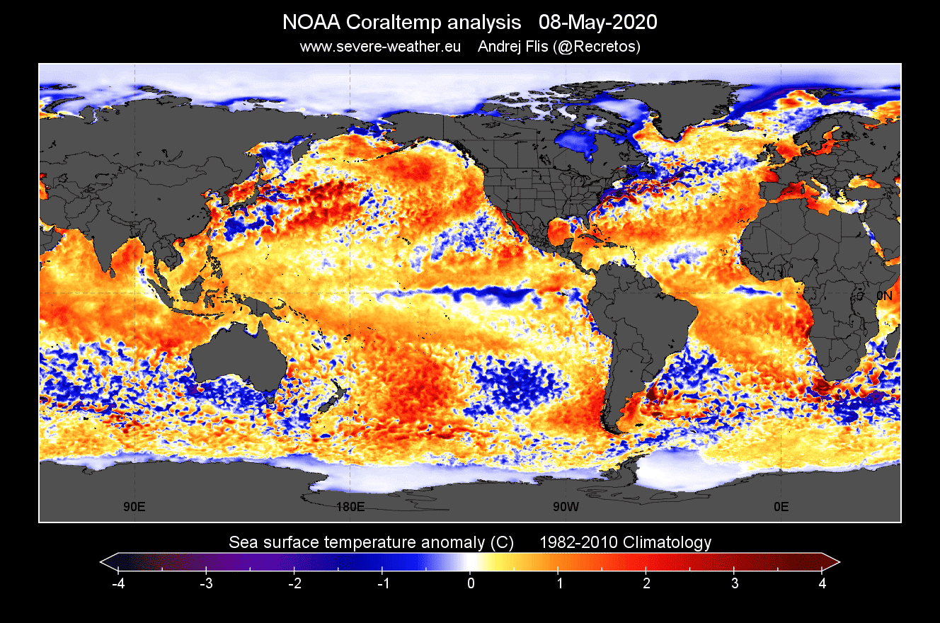
The latest analysis reveals a negative anomaly developing in the central ENSO regions. The second image shows the cooler waters in the ENSO regions, seen as a stripe of brighter colors, going westward from South America across the equatorial Pacific. On a side note, you can see the warm Gulf stream up along the E coast of North America, running from the Carribeans into the North Atlantic.

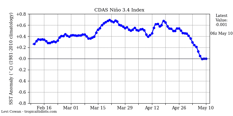
The analysis time series shows that the ENSO 3.4 region (from which we calculate the phases), was mostly in the neutral-warm phase in the past few weeks, but has now begun to cool down. This is an early indication that the regime in the tropics is soon going to change, as ENSO phasing usually starts when we get closer to summer.
We also produced an analysis of subsurface temperatures across the ENSO regions, observing the activity a few hundred meters below the surface. We have a comparison of April anomalies and the forecast for mid-May. In April, we can see that warmer waters were still present near the surface in the eastern parts. But a month later, around mid-May, those warmer waters are almost gone, and colder deeper waters are rising towards the surface. This is a strong indicator that there is a lot of colder than normal water below the surface, ready to rise and fully initiate a La Nina event.


The forecasts currently do trend towards a negative phase (a La Nina) as we go into summer and autumn. The first image below shows the NASA GEOS-5 model forecast of the temperature anomaly in the ENSO 3.4 region. We can see that by late summer, it is already below -0.5°C, which is the threshold for La Nina if sustained. It reaches -1°C by the end of the year, which would make this a moderate La Nina event.
The second image is from the NMME multi-model system, showing the sea surface temperature anomaly forecast for the end of 2020 (Oct-Nov-Dec), revealing a fully developed cold ENSO (La Nina) event.


La Nina global impact:
Each ENSO phase has a different impact on global weather patterns and the positioning of the jet stream. The graphics below from NOAA nicely outline the major jet stream position difference in each phase and main impacts during winter and summer. Of course, the ENSO phases have global implications beyond those that are shown on the graphics.


A negative phase, La Nina, is usually associated with stronger hurricane activity in the Atlantic, increasing the risk of landfall and damage across the many islands in the tropical regions and also for the coasts of the USA. A La Nina event has a specific impact on pressure patterns and tropical circulation, providing favorable conditions for tropical systems to power up as they move across the tropical Atlantic.
The first graphic below shows the tropical sea surface temperature pattern during high power hurricane years. We can see that it shows negative temperatures in the ENSO region, indicating a La Nina, as the most favorable ENSO phase. It also shows warmer temperature