Tropische Storm Gonzalo wordt nu mogelijk ook een orkaan.
Bericht van: Jelmer (Vlaardingen) , 22-07-2020 17:44In de update van 11.00 uur vanmiddag werd er nog uitgegaan van een maximale intensiteit van 60 mph (storm), maar nu is dat verhoogd naar 80 mph (orkaan). Er is nog wel zeer veel onzekerheid. Modellen 'gespecialiseerd' in dit soort systemen laten het een (forse) orkaan worden, globale modellen als GFS en ECMWF laten deze juist volledig 'uitdoven'. Een stukje de discussie/voorspelling.
Satellite imagery indicates that the cyclone has become
significantly better organized since the last advisory.  Visible
imagery shows a well-defined central dense overcast with a hint of
an eye and an outer convective band in the western semicircle, while
a 09Z GMI microwave overpass showed a well-defined inner convective
ring feature.  Various subjective and objective satellite intensity
estimates range from 35-55 kt, so the initial intensity is raised to
a possibly conservative 45 kt.

The initial motion is now 270/10.  Gonzalo is on the south side of
a low- to mid-level subtropical ridge, and this feature should
steer the storm generally westward at a faster forward speed for
the next 3 days or so.  After that time, a motion toward the
west-northwest is expected.  The new NHC forecast track is little
changed from the previous track, and it lies very close to the
consensus models.

The intensity forecast remains very problematic and of low
confidence. On one side, the cyclone has been strengthening quickly
and the good organization suggests additional, and possibly rapid,
strengthening should occur.  In addition, the SHIPS-based guidance
and the HWRF make the system a hurricane and keep that intensity
through 120 h.  On the other side, the GFS, UKMET, ECMWF, and
Canadian models are not big fans of this system, as they all
forecast it to either be a weak low or dissipated by 120 h, possibly
due to dry air entrainment and large-scale subsidence.  The NHC
intensity forecast again compromises between these extremes, showing
Gonzalo peaking as a hurricane in 36-48 h, followed by weakening in
deference to the global models.  The new intensity forecast has
significantly higher intensities than the previous forecast for most
of the forecast period based on the recent intensification.  As
noted before, the small size of this system makes it susceptible to
significant fluctuations in intensity, both upward and downward.
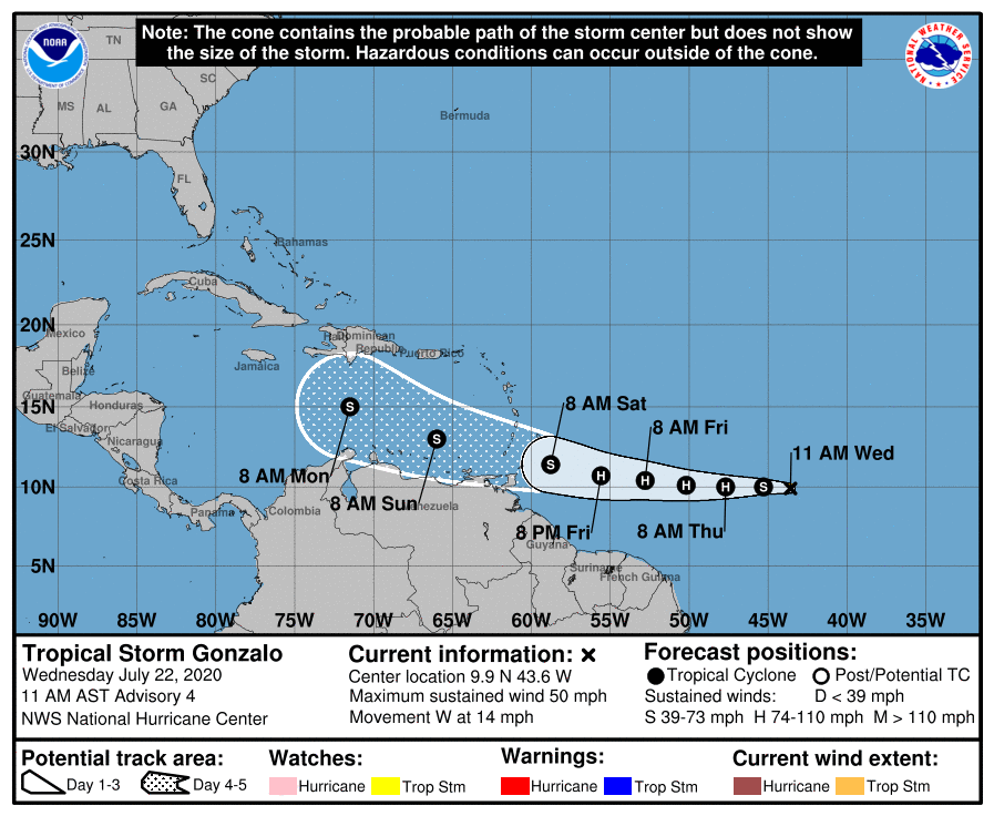
Actuele weerkaarten en verwachtingen: Weatherconsult.nl