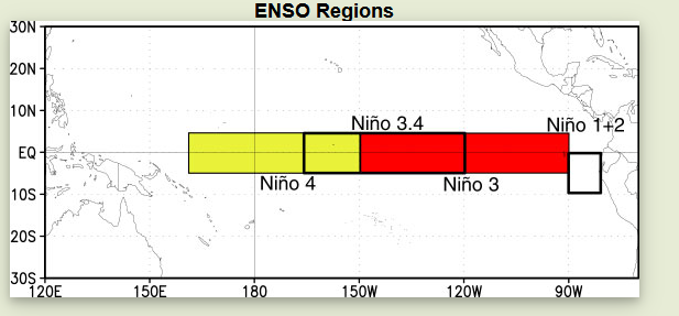
Het gebied rond de evenaar in de Pacific is voor het bepalen van de ENSO (La Nina, neutraal en El Nino) opgedeeld in vier gebieden. Die zie je hieronder.
Historically, scientists have classified the intensity of El Niño based on SST anomalies exceeding a pre-selected threshold in a certain region of the equatorial Pacific. The most commonly used region is the Niño 3.4 region, and the most commonly used threshold is a positive SST departure from normal greater than or equal to +0.5°C. Since this region encompasses the western half of the equatorial cold tongue region, it provides a good measure of important changes in SST and SST gradients that result in changes in the pattern of deep tropical convection and atmospheric circulation. The criteria, that is often used to classify El Niño episodes, is that five consecutive 3-month running mean SST anomalies exceed the threshold. https://www.ncdc.noaa.gov/teleconnections/enso/indicators/sst/
Of kijk eens hier https://climatedataguide.ucar.edu/climate-data/nino-sst-indices-nino-12-3-34-4-oni-and-tni
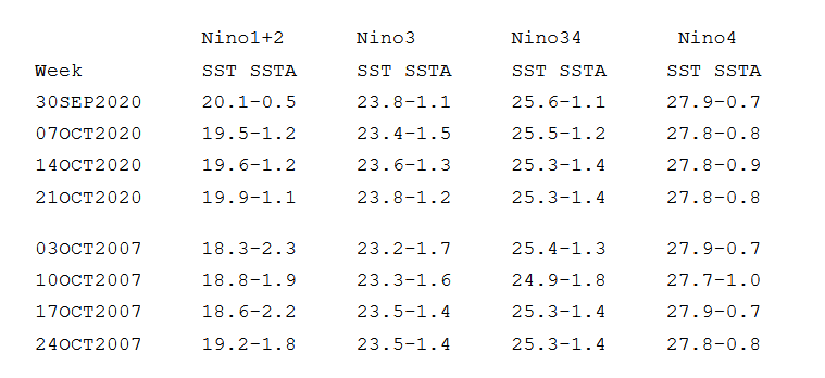
Daaronder zie je een plaatje met de ontwikkeling van de zeewatertemperatuur in de vier gebieden. Duidelijk is dat de grootste afkoeling plaatsvind in zone 3. In het oosten dus. East based La Nina? Op dit moment wel. We wachten rustig af.