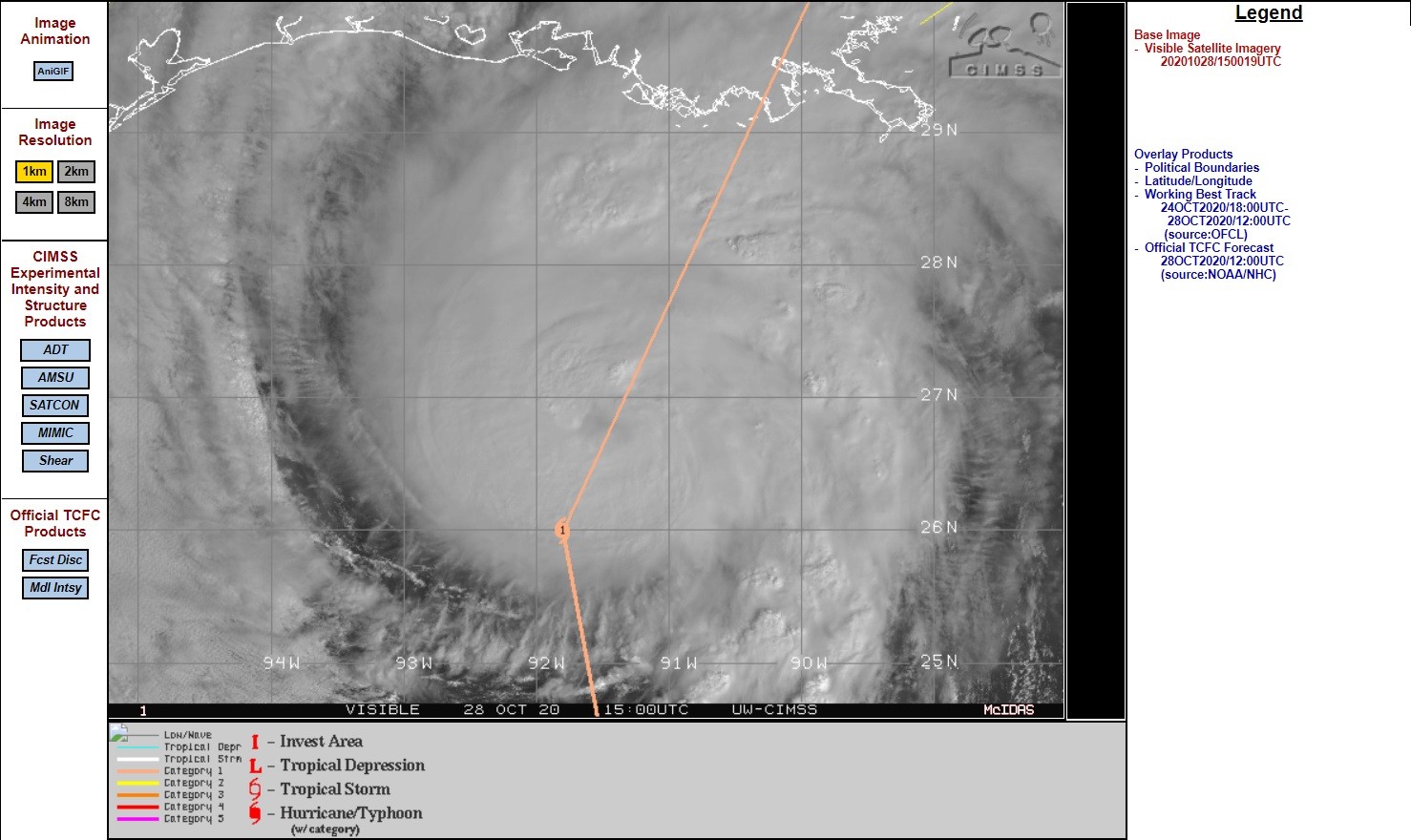
Na passage van het Yacutan schiereiland is hij weer flink aangesterkt tot 150 km/h gemiddeld. Dat is randje cat 2 en een stuk sterker dan eerst verwacht werd bij landfall in de VS.
000
WTNT33 KNHC 281448
TCPAT3

BULLETIN
Hurricane Zeta Advisory Number  16
NWS National Hurricane Center Miami FL       AL282020
1000 AM CDT Wed Oct 28 2020

...CONDITIONS DETERIORATING ALONG PORTIONS OF THE NORTHERN GULF
COAST...
...LIFE-THREATENING STORM SURGE AND DAMAGING WINDS LIKELY IN THE
WARNING AREAS LATER TODAY...


SUMMARY OF 1000 AM CDT...1500 UTC...INFORMATION
-----------------------------------------------
LOCATION...26.9N 91.7W
ABOUT 220 MI...355 KM SW OF THE MOUTH OF THE MISSISSIPPI RIVER
ABOUT 235 MI...380 KM SSW OF NEW ORLEANS LOUISIANA
MAXIMUM SUSTAINED WINDS...90 MPH...150 KM/H
PRESENT MOVEMENT...N OR 10 DEGREES AT 18 MPH...30 KM/H
MINIMUM CENTRAL PRESSURE...976 MB...28.82 INCHES


WATCHES AND WARNINGS
--------------------
CHANGES WITH THIS ADVISORY:

The Tropical Storm Watch west of Morgan City to Intracoastal City,
Louisiana is discontinued.

SUMMARY OF WATCHES AND WARNINGS IN EFFECT:

A Storm Surge Warning is in effect for...
* Mouth of the Atchafalaya River to Navarre Florida
* Lake Borgne, Lake Pontchartrain, Pensacola Bay and Mobile Bay

A Hurricane Warning is in effect for...
* Morgan City Louisiana to the Mississippi/Alabama border
* Lake Pontchartrain, Lake Maurepas, and Metropolitan New Orleans

A Tropical Storm Warning is in effect for...
* Mississippi/Alabama border to Walton/Bay County Line Florida

A Storm Surge Warning means there is a danger of life-threatening
inundation, from rising water moving inland from the coastline in
the indicated locations. For a depiction of areas at risk, please
see the National Weather Service Storm Surge Watch/Warning Graphic,
available at hurricanes.gov.  This is a life-threatening situation.
Persons located within these areas should take all necessary actions
to protect life and property from rising water and the potential for
other dangerous conditions. Promptly follow evacuation and other
instructions from local officials.

A Hurricane Warning means that hurricane conditions are expected
somewhere within the warning area.  Preparations to protect life and
property should be rushed to completion.

A Tropical Storm Warning means that tropical storm conditions are
expected somewhere within the warning area.

For storm information specific to your area, including possible
inland watches and warnings, please monitor products issued by your
local National Weather Service forecast office.


DISCUSSION AND OUTLOOK
----------------------
At 1000 AM CDT (1500 UTC), the center of Hurricane Zeta was located
near latitude 26.9 North, longitude 91.7 West. Zeta is moving toward
the north near 18 mph (30 km/h).  A faster northward to north-
northeastward motion is expected through tonight followed by an even
faster northeastward motion on Thursday and an east-northeastward
motion early Friday.  On the forecast track, the center of Zeta will
make landfall in southeastern Louisiana this afternoon.  Zeta will
then move close to the Mississippi coast this evening, and move
across the southeastern and eastern United States on Thursday.

Maximum sustained winds are near 90 mph (150 km/h) with higher
gusts.  Some additional strengthening is possible during the
next few hours, and Zeta is expected to reach the northern Gulf
Coast as a hurricane before weakening over the southeastern United
States on Thursday.

Hurricane-force winds extend outward up to 35 miles (55 km) from the
center and tropical-storm-force winds extend outward up to 150 miles
(240 km).

The minimum central pressure estimated from Air Force Hurricane
Hunter aircraft observations is 976 mb (28.82 inches).
https://www.nhc.noaa.gov/text/refresh/MIATCPAT3+shtml/281448.shtml