https://easternmassweather.blogspot.com/2021/10/la-nina-comes-into-focus-as-more-active.html
La Nina Comes into Focus as More Active Pattern Ensues
There have been some important morphologies regarding the overall structure of la nina as this particular ENSO event nears maturation. Last month we discussed the different types of la nina and noted that the event was of the mixed variety with a slight lean to the east.


This understandably caused some speculation that this particular la nina episode was transitioning into a modoki event.

However, the continued cooling and expansion of the coolest subsurface anomalies beneath region 3.4 has had an impact both regard to intensity and structure throughout the month of October.

 Secondly, the western flank of region 4 has stabilized at -0.6c while the eastern end of region 1.2 has cooled back drastically once again from +0.5c on 9/29 to -0.7c as of 10/20. This in conjunction with the continued expansion of the cooling subsurface to the east ensures that this particular event, while it may reach moderate ONI designation, will not be of the modoki variety.

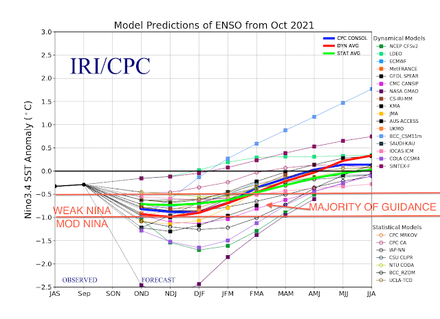
Firstly, the central regions of 3 and 3.4 have cooled rather dramatically to an anomaly of -0.8c as of 10/20, which is down from just -0.1c and -0.4c respectively on 9/29. This has increased what were formerly perceived as being relatively slim odds of a moderate ONI peak to approximately 50%.
This is reflected in the latest IRI intensity plumes.

Potential Ramifications for Winter
The forecast evolution of the cold season will be explicitly discussed in great detail with the release of the 2021-2022 Eastern Mass Weather winter outlook next week. However, it is not far fetched to view a potentially destructive nor' easter that is forecast to deposit several inches of rainfall from today through Wednesday, while producing coastal flooding and wind gusts of 50mph+ as a potential harbinger of an active pattern ahead.

November Composite:
Here is a sneak preview of the analog composite for the month of November, which does indeed hint at a potentially active regime to start the cold season:

Versus the currently visual from the Euro weeklies:


The following is the forecast composite for the month of October:

versus the actual pattern through 10/23:

Stay tuned for much more to come in early November-
„Et nul ne se connait tant qu'il n'a pas souffert, „C'est une dure loi, mais une loi suprème, „Vieille comme le monde et la fatalité, „Qu'l nous faut du malheur regevoir le baptéme, ~Et qu'a ce triste prix tout doit étre acheté. „Les moissons pour murir out besoin de rosée, „Pour vivre et pour sentir l'homme a besoin de pleura, „La joie a pour symbole une plante brisée, „Humide encore de pluie et couverte de fleurs."