De modelletjes voor winter 2022. Voor wie helemaal nieuw is, dit zijn berekeningen voor maanden vooruit. Experimenteel.
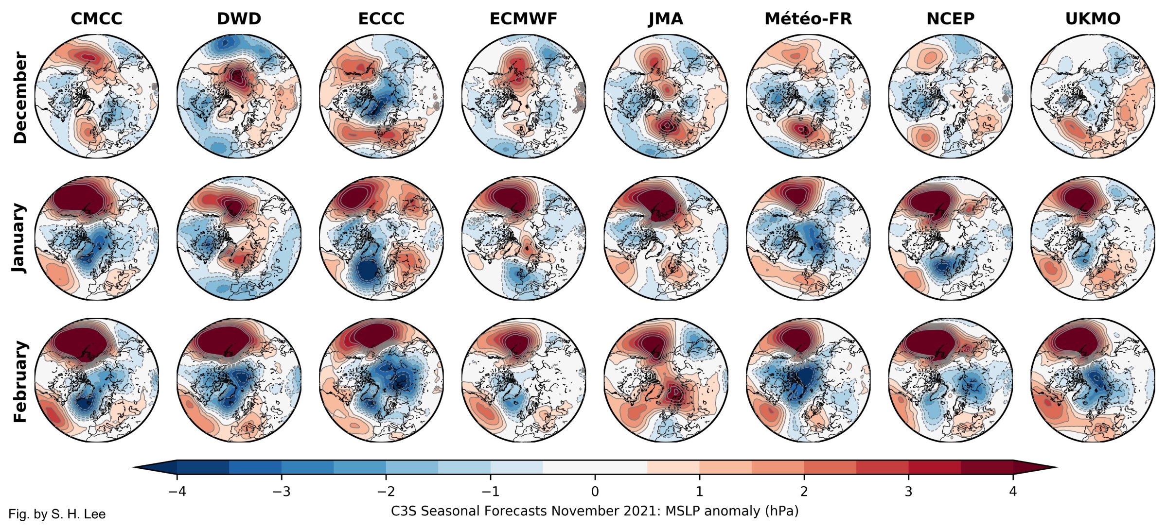
CMCC shows a largely positive AO/NAO winter, with the signal increasing in intensity during the winter. This is consistent with the model predicting a neutral or stronger-than-normal vortex, though this model has a large bias which may affect its representation of the vortex.
DWD shows a negative AO/NAO pattern during Dec & Jan, before switching to a strongly positive AO/NAO during Feb. This is consistent with the model showing a weak polar vortex during Dec, strengthening later -- though this model also has a notably biased stratosphere.
ECMWF shows a signal for a more negative AO/NAO during Dec & Jan, turning positive later. This is also consistent with the model predicting a weaker polar vortex during December, strengthening later.
JMA shows quite a lot of European/Scandinavian blocking throughout the winter, and particularly in February. This does not appear to be obviously related to the model's 10 hPa U-winds, but it too shows a weaker vortex in early winter strengthening later.
Météo-France evolves toward a more positive AO/NAO as the winter progresses. There is no particularly notable signal in the model's 10 hPa forecast.
Finally, the Met Office shows a near-normal or slightly weaker vortex in the early winter, shifting toward a stronger vortex later on -- consistent with an intensification of a positive surface AO pattern
There seems to be broad agreement of a weaker vortex (not necessarily major SSW, though!) earlier (mostly Dec/early Jan), strengthening later in the winter, with an associated tendency toward a positive Arctic/North Atlantic Oscillation at the surface later in the winter.
Therefore, the specific subseasonal stratospheric evolution may be an important reason why these forecasts evolve the way they do. If the vortex were instead to ramp up in strength earlier in the winter, that might throw these forecasts off sooner.
Bericht laatst bijgewerkt: 13-11-2021 15:57
Zwarte, dreigende wolken worden soms uit alle hemelstreken nog door den dampkring, die ons omringt, heen gejaagd en ontbinden zich dan niet zelden in koude, somtijds met sneeuwvlokken vermengde regendroppelen of kletterenden hagel, die de ontspruitende grashalmen en de teedere bloemen, welke reeds de lagchende knopjes in den koesterenden zonneschijn ontsloten, met verwoesting dreigen; maar geen nood! achter die donkere wolken is de Lente geboren. Petronella Moens.