Boven de Golf van Bengalen, ZO van India, is tropische storm Mocha in ontwikkeling. De verwachting is dat deze zal uitgroeien tot orkaanstatus en richting Myanmar en Bangladesh koerst.
Zoom Earth | Weerkaarten, live stormtracker
Cyclone Mocha to Make Landfall Between Bangladesh-Myanmar This Sunday: IMD | Weather.com
De schaalverdeling in die regio is wel anders. Een 'severe cyclonic storm' haalt nog geeneens orkaankracht (als de grootheid voor windsnelheid klopt tenminste)
Wednesday, May 10: After having developed for several days, Cyclone Mocha will finally emerge today, poised to unleash its wrath upon the coastal regions in the Bay of Bengal.
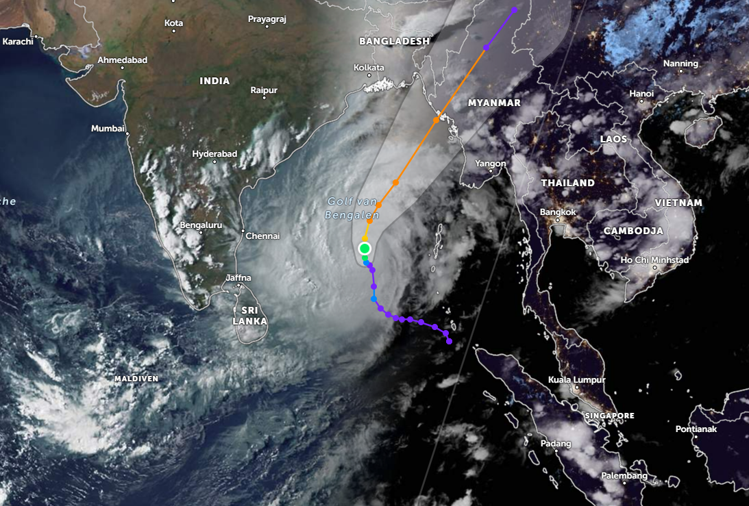
According to the India Meteorological Department’s (IMD) latest update, the system intensified into a Deep Depression over southeast Bay of Bengal during the early hours of Wednesday morning. As of 5:30 am today, it lay centred about 540 km west-southwest of Port Blair (capital city of Andaman-Nicobar Islands) and 1350 km south-southwest of Sittwe (Myanmar).
In this very part of BoB, the Deep Depression is expected to intensify into a Cyclonic Storm by today evening. For context, a system is categorised as a Cyclonic Storm when its 3-minute average maximum sustained wind speeds fall between 63-88 kmph.
Cyclone Mocha will then move north-northwestwards over southeast and adjoining central BoB, and gradually strengthen into a Severe Cyclonic Storm (wind speed 89-117 kmph) by Thursday morning and a Very Severe Cyclonic Storm (118-165 kmph) by Friday morning.
Thereafter, it will gradually recurve, move north-northeastwards and start weakening by Saturday (May 13). Come Sunday (May 14) afternoon, it will make landfall over southeast Bangladesh and north Myanmar coasts — between Cox’s Bazar (Bangladesh) and Kyaukpyu (Myanmar) — as a Severe Cyclonic Storm, with a maximum sustained wind speed of 110-120 kmph, gusting to 130 kmph.
As for its impact, the system will continue to dump heavy to very heavy rains (64.5 mm-204 mm) across Andaman and Nicobar Islands till Thursday, followed by just heavy showers on Friday.
And as it edges closer to India’s northeastern coast, Cyclone Mocha will also trigger heavy to very heavy rains over Northeast India on Sunday and next Monday (May 13-14).
In the meantime, the sea conditions all over BoB will remain rough to very rough, and the fisherfolk have accordingly been advised against venturing into the waters. All off-shore activities in the region have also been suspended while the cyclone’s impact persists.
For more information and detailed coverage of Cyclone Mocha's intensification, movement and impact, stay tuned to The Weather Channel India.