Het gaat momenteel al flink los in Noord-Italië. Grote hagel tot 11cm is waargenomen. Het zijn wederom de gebieden die al eerder getroffen zijn door noodweer. Ook de Balkan is weer aan de beurt.
LFC will yield conditions favorable for initiation and numerous isolated supercells will form, moving towards the lowlands. Supercells will, similarly to the previous days, pose risk of very large to perhaps even giant hail and severe wind gusts. A potential for upscale growth will exist and a convective system may cross from N Italy towards Istria.
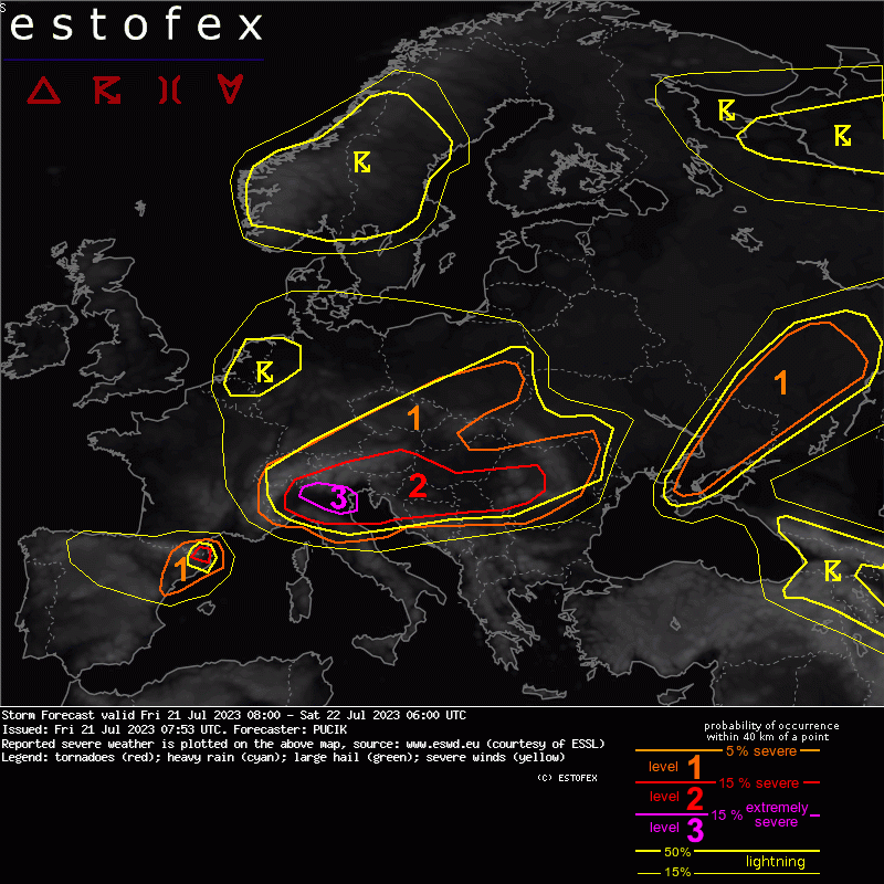
... S Austria, Croatia, Slovenia, S Hungary, N Serbia, W Romania ...
Similarly to N Italy, an overlap of abundant CAPE and 25+ m/s of 0-6 km bulk shear is forecast. The scenario over this region is complicated by a number of storms already existing over the domain and considerable cloudiness and stratiform rainfall over S Austria. Over Slovenia, as of 07 UTC, several both left- and right- moving elevated supercells have initiated. These will already pose risk of (very) large hail. Anvils of the supercells advected east may inhibit solar heating over the adjacent areas. It is also possible that some of these morning storms will become eventually surface-based and move far towards east.
A lvl 3 was considered also for this region, but uncertainty concerning the exact corridor of the most severe weather remains. Nevertheless, a boundary moving S/SE across the area, plus the upslope flow, will initiate numerous storms that spread across the area especially in the late afternoon to evening hours. Expect a combination of supercells and linear segments, posing very large hail and damaging wind gust threats. As the S-moving cold front undercuts the E-moving storms, they will become elevated especially towards the overnight hours.
A tornado risk is forecast to develop over Slovenia and N Croatia during the late afternoon to evening hours with 0-1 km bulk shear exceeding 10 m/s in some models, combined with curved hodographs and rather low LCLs. If isolated supercells exist over the area at this time, low-level rotation trends need to be monitored in the storms to detect a potential development of a tornadic supercell.