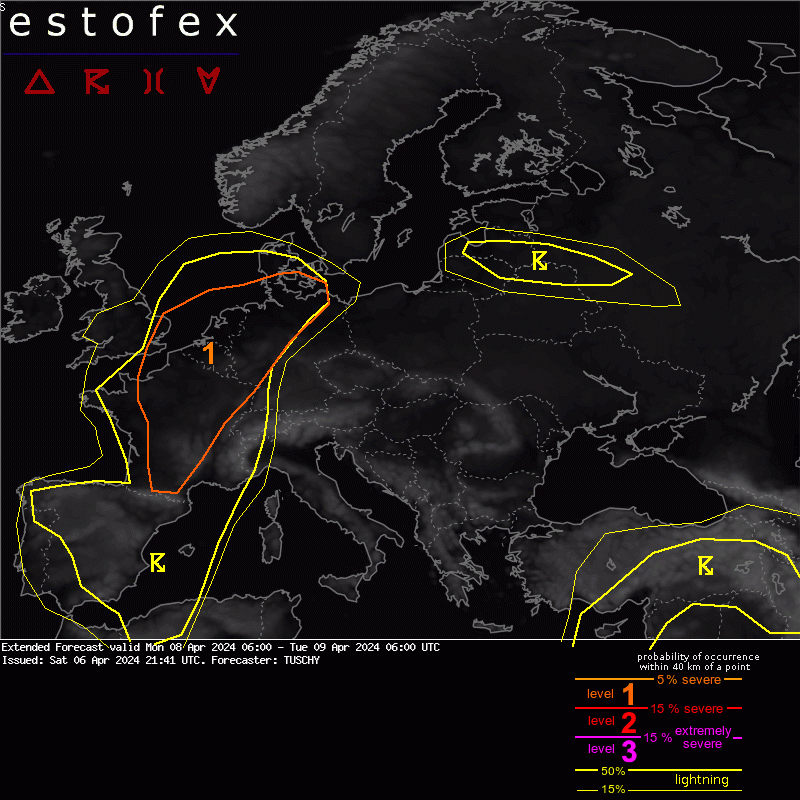
A level 1 was issued from France into N-Germany mainly for severe wind gusts, large hail and an isolated tornado threat.
SYNOPSIS
The main story is a progressive longwave trough just W of Europe. This feature amplifies in response to a digging anticylonic jet along its upstream flank and sharpens throughout the forecast with an impressive amount of shear/curvature vorticity along its base but also next to an embedded vort max, which lifts towards UK. This scenario causes constant height falls from UK/France to the W-Mediterranean. IFS-ENS indicates some probabilites for weak cyclogenesis over the W Mediterranean but also highlights the lifting vortex over UK with tight clustering.
A robust lead wave is forecast to cross Benelux/NW Germany during the afternoon into the overnight hours from SW to NE.
E of this trough a record shattering subtropical ridge still covers most of the CNTRL Mediterranean with numerous waves cirling this ridge from Scandinavia into Russia.
Otherwise a quasi-stationary upper low still sits atop the far E Mediterranean with ongoing unsettled conditions.
Along the surface, a broad warm sector over CNTRL Europe gets framed by an eastbound moving meridionally aligned cold front over E Spain into CNTRL France and a wavy warm front, which runs from N France E/NE all the way to N Poland/Belarus.
Overall NWP guidance is stable in placing the synoptic features of interest including the lead wave over Benelux. EPS data indicates some uncertainties in how far this French trough will amplify and how far NE the vortex over the UK will move. At LL, IFS indicates a broad low pressure channel, extending E from the English vortex towards Benelux and into N Germany. Embedded potential weak cyclogenesis is indicated by numerous member maxima with weak pressure anomalies.
DISCUSSION
BENELUX into NW Germany. The passing short wave, falling pressure and a northward pushing warm front should be adequate for late afternoon/evening convection. Enhanced moisture pooling along the confluent LL wind field (the warm front) with some background support should assist in at least isolated CI. Kinematics are impressive and organized convection occurs with any structuring updraft. Either large hail for more elevated cells or cells with all kind of severe along/S of the warm front are forecast with initiation depending on mesoscale support. Of growing concern is a 60kt speed max. at 700 hPa, well anticipated from most models and pushing into W-Germany during the afternoon hours with impressive hodographs for well organized mesocyclones. Ongoing isues with CAPE magnitude, insolation (departing DIBS) and still uncertain final magnitude of (synoptic/mesoscale) lift preclude an upgrade for now. This acitivity shifts NE into N-Germany during the night with an ongoing severe risk.
We nudged the level 1 into SE UK to account for a temporal untable warm sector with adequate CAPE/shear for organized convection during the day. This however depends on the final mass response to the approaching vortex with ongoing uncertainties in NWP guidance. Still, confidence is increasing and hence the level 1 upgrade for now.