BRON: Estofex
Storm Forecast
Valid: Sat 29 Jun 2024 06:00 to Sun 30 Jun 2024 06:00 UTC
Issued: Fri 28 Jun 2024 20:19
Forecaster: TUSCHY
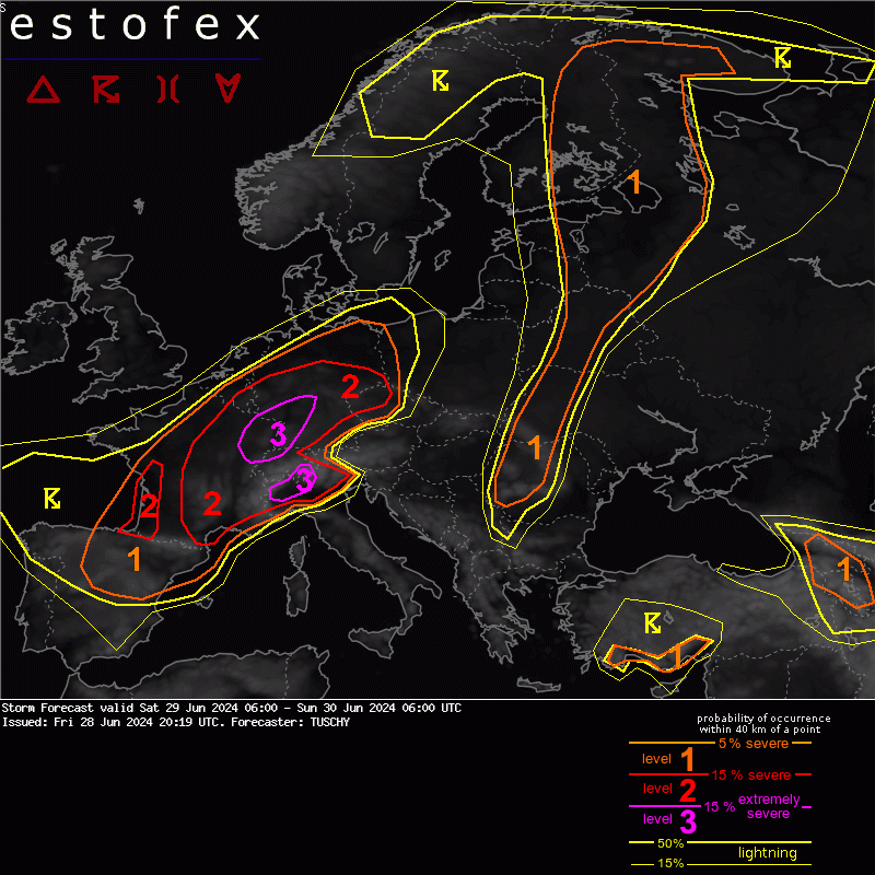
A level 3 was issued across parts of E-France to far NW Switzerland into SW Germany for damaging gusts, very large hail and excessive rain.
A level 2 surrounds the level 3 and covers the similar hazards but with a somewhat lowered confidence level. A regionally augmented tornado risk is present with a strong event possible.
A level 1 surrounds all level areas with all kind of hazards but lower probabilities.
DISCUSSION
***A regional outbreak of severe thunderstorms with very large to destructive hail, damaging wind gusts and excessive rain is forecast, including a regionally enhanced strong tornado risk***
... E-France into Germany and NW Switzerland ...
A weakening but still potent low-amplitude wave draws near from the SW during the day. It gets accompanied by a 80kt upper jet with a diffluent and divergent exit region overspreading a very unstable warm sector, although this jet weakens before entering Germany. This wave induces constantly lowering pressure over most of France into W-Germany during the day, which remains rather diffuse and results in a SW-NE aligned broad low pressure channel probably with an embedded surface circulation over E-France. This low merges with another structuring low over SE Germany, which shifts N during the night and both merge to one dominant LL depression over N/NE Germany towards the end of this forecast period.
Embedded in this low pressure channel is a wavy front, which runs from CNTRL France to CNTRL Germany and turns into a structuring and northward moving warm front.
The warm sector airmass features unseasonable moist BL conditions with BL mixing ratios in the 12-15 g/kg range with even higher peaks towards the Upper Rhine, translating to dewpoints in the upper tens to lower twenties. Some places along the northward surging warm front may see a Td increase in excess of 10K within 12-15h. A northward spreading EML with mid-level lapse rates in excess of 7K/km interacts with this warm sector airmass and yields afternoon MUCAPE values in the 2000-3000 J/kg range with local 4000-5000 J/kg peaks possible atop regions with maximed BL moisture (e.g. Upper Rhine). Strong WAA (partially enhanced by Alpine downslope component) pushes 850 hPa temperature in the 20-26 C range, which adds modest capping to most of the German warm sector throughout the day, whereas cap weakens towards CNTRL Germany and France. Also, a drying/mixing BL N of the Alps assist in capping issues.
DLS values during peak heating oscillate around 15-20 m/s with 0-3 km shear values hovering around 10-15 m/s. An increase of the 0-3 km shear vector is forecast from the evening onwards (as the wave approaches).
During the afternoon, a few thunderstorms may erupt along the warm front, as ongoing WAA interacts with the more complex orography and as a vorticity lobe/short-wave crosses the warm front east/northeastwards while CAMs show virtually now cap (if strong diabatic heating verifies!).
Point source forecast soundings indicate 3000 J/kg MUCAPE with 15-20 m/s DLS and enhanced SRH areas in a strong WAA regime along the boundary. A few longer-tracked supercells with very large hail, severe downdraft gusts and excessive rain are forecast in case they ride the boundary to the E (as forecast by the Bunkers motion). Somewhat lowered LCLs with pooled moisture adds a tornado risk to this activity with a strong event possible. This isolated risk extends from Belgium to CNTRL Germany into N Czechia. Although NWP guidance still diverges with this event (e.g. ID2 ensemble with only a few members showing CI), confidence in isolated CI is high enough for adding a level 2.
During the same time (early afternoon hours onwards), the focus then turns to SE into E France and W/NW-Switzerland. A broad belt of 15-20 m/s DLS and similar shear values in the lowest 3km overlap with abundant CAPE, so combined with the incoming forcing from the SW and diurnal heating, scattered severe thunderstorms erupt. Even with dusty cloudiness only temporal diabatic heating should be enough for CI as surface temperatures soar into the upper twenties. Amount of CAPE and incoming forcing should cause scattered to widespread CI.
Any maturing updraft becomes long-lived and has plenty of shear to work with. A mix of long-lived supercells and severe bow echoes is forecast with all kind of severe and extremely severe hazards, including very large to giant hail, excessive rain, severe/damaging swaths of severe wind gusts and a few tornadoes, including a strong one (especially in case of lowered LCLs by previous convection). Widespread CI may cause erratic storm interactions betimes with a fast tendency of growing clusters. Colliding convection may bring a risk of local life-threatening flash flooding issues!
As we move deeper into the evening hours, the focus then shifts from a more discrete storm mode to a clustered/semi-discrete one. A mixture of long-lived tail-end supercells, embedded bow echoes and a growing severe MCS should cause enough (extreme) reports for justifying a focused upgrade to a level 3 from NW-Switzerland into E-France and towards SW/CNTRL-Germany. If we get a severe MCS going while entering SW Germany, a long swath of damaging hail/severe gusts can occur. Highest confidence for such an event is a potential MCS tracking along the French/Swiss border into the Upper Rhine, where most extreme CAPE awaits convection.
Mature convection probably starts to outrun the surface based CAPE plume somewhere over CNTRL Germany, before riding along the sloped frontal zone towards NE Germany during the night. Although the severe risk decreases, hail and heavy rain remain an ongoing hazard. We would not be surprised to see a lingering severe risk into Saxony/NW Czechia as the MCS builds SE into the CAPE plume. All kind of hazards persist until the end of the forecast period with this activity including severe gusts in case we see enough BL modification for surface based activity.
We broadened the level 2 well into Bavaria to account for CI more E into the reservoir of rich CAPE. In case this scenario verifies, the risk turns to very large hail and severe downbursts with more elevated convection and thick MUCAPE profiles above the cap.
Another concern arises from CNTRL France into Belgium and NW-Germany from the afternoon into the overnight hours as the risk spreads NE.
Growing convection moves into the W fringe of any structuring low/ low pressure channel, where the storm relative component (e.g. northerly sfc component pushing Bunkers storm motion near zero) slows down the convection. In case we get one or two more dominant LL vortices, slow moving/training convection may bring major and (on a local scale) potential life threatening flash flood issues in a very moist background environment (PWs in the 40-45 mm range and abundant CAPE). Although extreme issues may occur more on a local scale, a rather broad level 2 was added to highlight this (partially nocturnal) risk, which also depends on the LL MSLP geometry. This risk continues over W-Germany beyond 06Z.