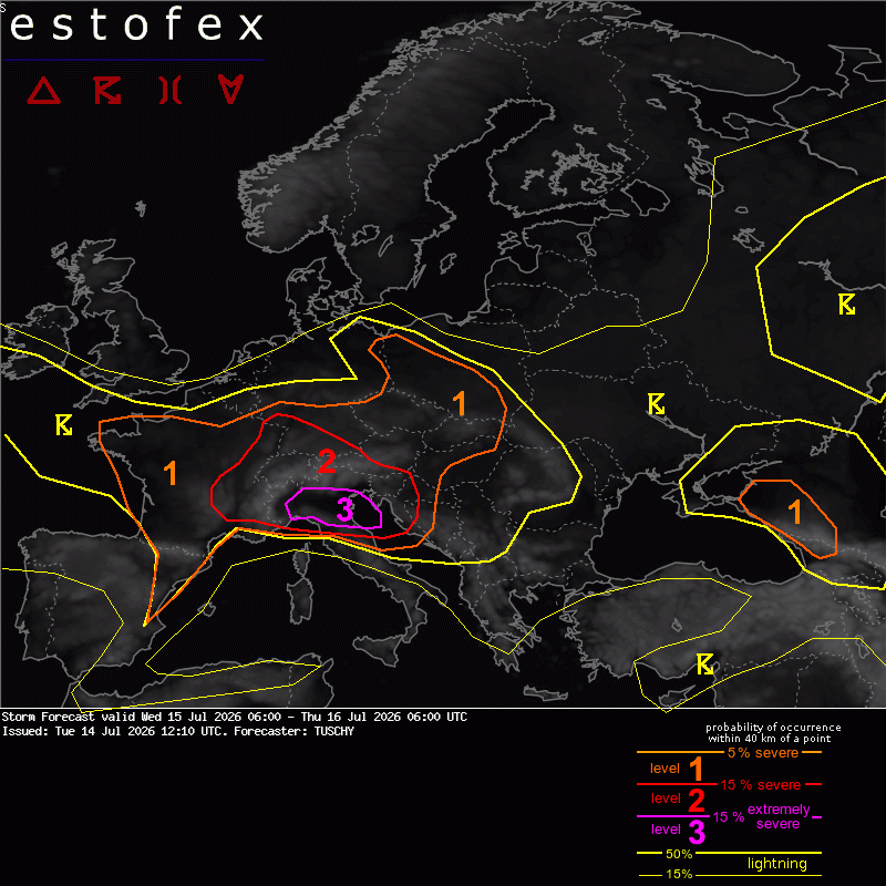
Estofex Level 3 voor N-Italië vanwege zeer grote tot gigantische hagel
Bericht van: Stefan (Wezep) , 14-07-2026 14:19Ja, het staat er echt: 'very large to giant hail'. Dat wordt weer peentjes zweten voor alle vakantiegangers die daar op vakantie zijn... is het niet vanwege de hagel dan is het wel voor de kans op een tornado die je caravan langs de Adriatische kust opslokt.
De volledige forecast: https://www.estofex.org/cgi-bin/polygon/showforecast.cgi?text=yes&fcstfile=2026071606_202607141210_3_stormforecast.xml
- - - - - - - - - - - - - - - - - - - - - -
Storm Forecast
Valid: Wed 15 Jul 2026 06:00 to Thu 16 Jul 2026 06:00 UTC
Issued: Tue 14 Jul 2026 12:10
Forecaster: TUSCHY
A level 3 was issued for parts of N Italy mainly for very large to giant hail and damaging gusts.
A level 2 surrounds the level 3 for large to very large hail, severe gusts and heavy to excessive rain. A tornado risk is present along the NW/N coastal fetch of the Adriatic Sea.
A level 1 surrounds the level 2 with similar hazards but lowered probabilities.
... S Switzerland to N Italy and S Austria into Slovenia and Croatia...
Two waves of (extremely) severe thunderstorms are forecast.
The first round will be convection along the S Alps from N Italy and S Austria. Initiating cells will see roughly 1000 J/kg MUCAPE, strong shear and a mixed BL, so large hail and severe gusts will be the main hazard. Further W, towards S Switzerland, firing convection will already be placed in a 2000 J/kg CAPE environment and strong shear, so rapid supercell development is forecast with very large hail and damaging gusts.
Betimes, convection from N Italy moves off the orography and into an extreme CAPE/shear space with MUCAPE up to 3500 J/kg and 25 m/s DLS, so rapid intensification is forecast. Very large hail (probably in the 5-8 cm range) is possible next to heavy rain and damaging gusts. Despite increasing CIN after sunset, this activity continues well into the night. This is also true for Slovenia int Croatia, where less CAPE but favorable kinematics support long-lived supercells. Damaging hail and severe gusts are forecast next to heavy rain.
Finally the regions Lombardy, Emilia-Romagna and Piemonte have to be highlighted for an augmented evening/overnight risk of long-tracked severe supercells/bow echoes. As the synoptic-scale wave approaches from the W, the mentioned extreme CAPE/shear space favors swaths of damaging hail, gusts and excessive rain along the highlighted regions. This activity is persistently highlighted by long/intense UH tracks and LPI maxima, so given the augmented risk of giant hail/hurricane-forced gusts, a confined level 3 upgrade was performed. This event also affects the N Adriatic Sea with dangerous offshore conditions during the evening/night.
SE-ward moving mature supercells, which interact with the onshore moving sea breeze front from the N Adriatic Sea could also pose a tornado risk despite well mixed BL conditons.