Bij deze de info:
Storm Forecast
Valid: Thu 27 Aug 2026 06:00 to Fri 28 Aug 2026 06:00 UTC
Issued: Wed 26 Aug 2026 21:03
Forecaster: PUCIK
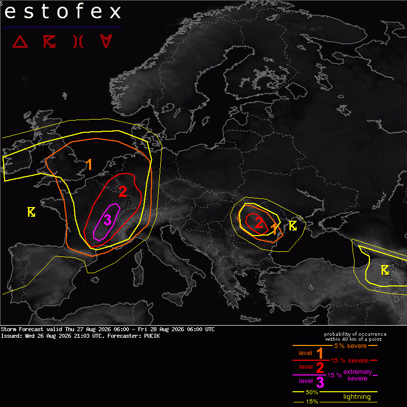
A level 3 was issued across SE/E France for large to very large hail, severe wind gusts, heavy rainfall and [strong] tornadoes.
A level 2 was issued from S France towards Switzerland mainly for large to very large hail, severe wind gusts and tornadoes.
A level 2 was issued from central France to Belgium and W Germany mainly for large hail, severe wind gusts and heavy rainfall.
A level 1 was issued across W France and NW Italy mainly for large hail and severe wind gusts.
A level 1 was issued in a belt from the UK through Netherlands into N Germany for heavy rainfall, large hail and severe wind gusts.
A level 2 was issued across Romania mainly for large hail, severe wind gusts and heavy rainfall.
A level 1 surrounds level 2 for same threats , but lower coverage.
DISCUSSION
... Massif Central to NW Switzerland and SW Germany ...
Unseasonably strongly sheared environment is forecast across the area with 0-6 km bulk shear reaching 30 to 40 m/s. Majority of the shear will be confined to the 2-6 km layer with 0-3 km bulk shear up to 20 m/s and 0-3 km SRH from 200 to 400 m2/s2. An impressive kinematic setup will support strongly rotating supercells with all hazards.
Supercells as the primary convective mode are unanimously confirmed by all high-resolution convection-allowing models consulted for this forecast. Storms will be initiated by a cold front combined with local orography. East of the cold front, more curved hodographs are forecast in the WAA regime. In the wake of the front, storms will be transition into an elevated mode with straighter hodographs. Mix of left- and right- movers will form around the front across the Level 3 with right-movers dominant. Supercell collisions are likely in this setup as the mean flow parallels the initiation boundary and supercells follow each other path. This is perhaps the biggest issue with the setup. Development of early to late morning storms over S France with rainout and outflow running over the Level 3 could lessen the overall threat or shift the highest risk more east/southeast. Storm development is expected from early afternoon to late evening and night hours.
Threat of very large hail is most likely across the southern part of the level 3, where the fattest CAPE profiles will exist with substantial buoyancy above -10 deg C isotherm. Threat of heavy rainfall will be the highest over the Massif Central where multiple storms may train over the same area and this threat will increase towards late evening and night. Tornado threat will be the highest here as well and in the Rhone valley with 0-500 m SRH locally exceeding 100 m2/s2 and low LCL environment. Strong tornado is possible given the impressive kinematic setup. Tornado wise, the most concerning situation will be between 18 and 21 UTC over southern Massif Central, where models show purely streamwise vorticity in the bottom 500 m combined with SRH even over 200 m2/s2 in that layer ahead of the front. Should a surface-based supercell cross such environment, [significant] tornado threat will be high. Presence of elevated or surface-based supercells will be key in whether the tornado risk will materialize within that time frame and beyond it. Threat of severe wind gusts will be the highest in the late afternoon hours in the direction of Switzerland and SW Germany, where higher LCL environment is forecast.
... N France to BENELUX and NW Germany ...
A frontal wave with mid-tropospheric trough will cross the region. Ahead of the cold front, skinny CAPE profiles are forecast with MLCAPE between 700 and 1500 J/kg and rather stable layer in the upper troposphere. Vertical wind shear will ramp up towards the evening with 0-6 km bulk shear around 20 m/s. 0-3 km shear will be rather weak most of the time, limiting the SRH values, perhaps with exception of some areas near the frontal wave that is forecast to move from N France through Belgium into W Germany. Expect a mix of multicells and supercells. Environment will not favour extremely severe hazards, but storm coverage will be high with some clustering and upscale growth possible. There will be a mix of large hail, severe wind gusts and heavy rainfall threat.
... UK ...
Scattered to widespread storms will form along the warm front advancing north. Moderate MLCAPE around 1000 J/kg is simulated with 0-6 km bulk shear between 10 and 15 m/s. Expect well-organized multicells and transient supercells in the zone of higher SRH along the warm front with isolated risks of heavy rainfall and large hail.
... Romania ...
Compared to the previous day, storm coverage is expected to increase given passage of short-wave trough in mid to upper troposphere. Furthermore, vertical wind shear will be stronger as well, reaching 15 to 25 m/s in the 0-6 km layer with predominantly straight hodographs. Splitting supercells are expected with threats of large hail and severe wind gusts. A level 2 instead of level 1 highlights increased risk from the previous forecast foreast period. It is questionable how many storms will make it over the lowlands of southern Romania, but will maintain a level 1 there as moderate CAPE and strong shear will cover this area as well.
... Romania ...
In northwesterly flow aloft, poor lapse rates, combined with modest low-level moisture will result in skinny CAPE profiles. 10 to 18 m/s of 0-6 km bulk shear are forecast with straight hodographs, suggesting multicells and some transient splitting supercells. Heavy rainfall and some large hail will be the main threats. Heavy rainfall will be most likely in the Carpathian area and along weak frontal boundary across the northern part of the highlighted area. More isolated mode is anticipated towards the lowlands.
... N Portugal, NW Spain ...
Once again, strong low-level shear will combine with marginal and skinny CAPE environment with questionable low-level thermodynamics. As the previous situations have not resulted in a single tornado based on the ESWD verification, decided to stay without a Level 1 to see whether atmosphere will deliver now. On a more serious note, the overlap of SBCAPE and higher 0-1 km SRH is smaller compared to the previous two situations. But some risk of tornadoes will still be present, besides local heavy rainfall event.
 nou gelukkig niet!