Voor sneeuw is het kantjeboord maar het zit er nog steeds in. De trog is gevuld met koude lucht op grote hoogte, de positie van het laag is van groot belang voor het al of niet tijdelijk aflandig zijn van de wind.
Spijtig dat het laagje nabij IJsland volgens ECMWF zo westelijk doortrekt.
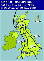
Verder zoals ik al aangaf lijkt de situatie voor het VK precair, UKMET heeft zoals ik gisteren al verwachtte een waarschuwing uit staan.
EARLY WARNING of Heavy Snow and Blizzards Issued by the Met Office at 10:46 on Monday, 21 November
OVERALL RISK ASSESSMENT: The probability of disruption due to severe weather conditions in part of the United Kingdom within the next 132 hours is 70 percent.
This is the first warning of disruption due to Heavy Snow and Blizzards.
The Met Office is forecasting a period of cold and very strong northerly winds across the country on Thursday and Friday, and perhaps also through Saturday, with all areas at risk of seeing some snow.
Highest risk areas are northern and eastern Scotland (where winds may reach severe gale force), and also eastern counties of England. Showers will fall as snow or hail widely over higher ground and at lower levels at times. Local blizzard conditions are expected over higher ground in the north and east.
This warning will be updated by 1000 on Tuesday 22 November 2005.
Spijtig dat het laagje nabij IJsland volgens ECMWF zo westelijk doortrekt.
Verder zoals ik al aangaf lijkt de situatie voor het VK precair, UKMET heeft zoals ik gisteren al verwachtte een waarschuwing uit staan.
EARLY WARNING of Heavy Snow and Blizzards Issued by the Met Office at 10:46 on Monday, 21 November
OVERALL RISK ASSESSMENT: The probability of disruption due to severe weather conditions in part of the United Kingdom within the next 132 hours is 70 percent.
This is the first warning of disruption due to Heavy Snow and Blizzards.
The Met Office is forecasting a period of cold and very strong northerly winds across the country on Thursday and Friday, and perhaps also through Saturday, with all areas at risk of seeing some snow.
Highest risk areas are northern and eastern Scotland (where winds may reach severe gale force), and also eastern counties of England. Showers will fall as snow or hail widely over higher ground and at lower levels at times. Local blizzard conditions are expected over higher ground in the north and east.
This warning will be updated by 1000 on Tuesday 22 November 2005.