ik denk dat het koufront te verzwakt is. Er zit ook niet echt een sterke jetstreak achter...
Bron van tekst en afbeeldingen: Satrep Manual
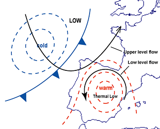
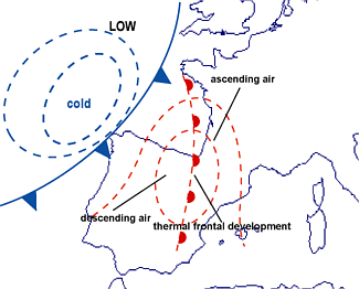
The strong heating of air near the surface over the Spanish plateau causes low-level heating, ascent and convergence. This leads to a formation of a thermal trough or low over the Iberian peninsula. The thermal low sets up a low-level cyclonic flow over the peninsula (Phase A). This includes the advection of cooler air and descending motion across the coastal areas of the Iberian peninsula and western France from the Bay of Biscay. The warm air advection intensifies over the interior of the peninsula, and the ascent of air continues within the warm plume (Phase B). This further accelerates falls in surface pressure.
The approaching Cold Front has an important role in the further development of the Spanish Plume in two ways:
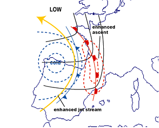
1. As the front approaches the continent, the existing thermal gradient intensifies. This strengthens the winds ahead of the trough; in addition, there is an intensification of warm advection and ascent within the warm conveyor belt ahead of the Cold Front (Phase C).
2. The possible over-running of cold air at upper levels from behind the front, and the further de-stabilization of the already highly unstable air within the Spanish Plume, can trigger deep convection.
The development of the Spanish plume. Solid lines: surface flow. Dashed lines: thermal flow.
Bron van tekst en afbeeldingen: Satrep Manual
 *NM
*NM