 :)
:)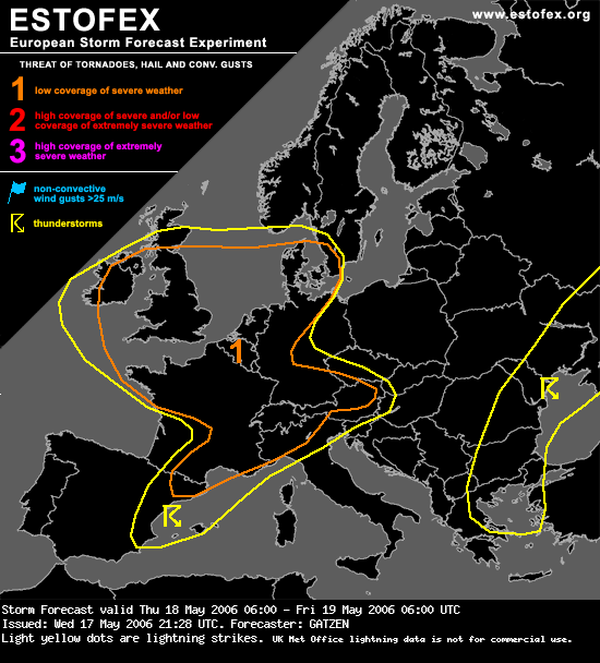
Storm Forecast
Valid: Thu 18 May 2006 06:00 to Fri 19 May 2006 06:00 UTC
Issued: Wed 17 May 2006 21:28
Forecaster: GATZEN
SYNOPSIS
A strong short-wave trough and associated vort-max runs into central Europe ... supporting Atlantic long-wave trough to expand into Europe ... and relatively zonal flow is expected to form at the end of the period. To the southeast ... subtropic ridge over western Mediterranean moves southeastward ... and eastern European trough cuts off over Black Sea region. At lower levels ... warm and moist airmass ATTM over France is advected into central and eastern Europe east of a cold front that is expected from eastern Poland to northwestern Mediterranean and central Iberian Peninsula at the end of the period. Over Balkans ... unstable airmass stabilizes in the range of upper ridge.
DISCUSSION
British Isles, North Sea region, northern France, Benelux, northern Germany
Cyclonic flank of strong mid-troposphere jet streak again reaching more than 70 kts over parts of France and Germany will be the focus of expected severe convection. Several very strong vort-maxima rapidely moving eastward with the mean flow ... will lead to strong DCVA over British Isles, France, Benelux, and Germany. Affected maritime airmass is expected to be convectively mixed in the range of the upper trough ... and should be characterized by rather rich low-level moisture and neutral to slightly unstable lapse rates. Daytime heating should likely be sufficient to build CAPE ... while CIN should be weak and LCL height might be rather low given GFS surface dewpoints around 10 C. As temperature advection should be weak as indicated by latest GFS model output ... quite intense linear QG forcing can be expected with the vort-maxima ... helping thunderstorms to form. Given strong vertical wind shear in the range of the upper jet ... thunderstorms should organize into bowing lines and/or shallow mesocyclones ... with severe wind gusts the most significant threat. However ... given strong LLS over British Isles, northern France, Benelux, and northern Germany during the period ... chance for tornadoes is forecast to be enhanced ... and a couple of events is expected over this rather large area. Large hail is not ruled out with the stronger storms. Thunderstorms are forecast to affect British Isles and France during the day ... and should spread into Benelux, and Germany during the night until the end of the period ... while severe potential should gradually weaken.