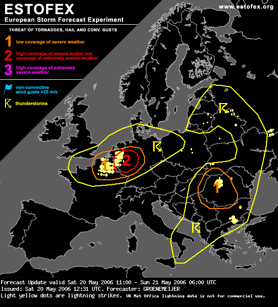
ESTOFEX: Level 2 (2e update)

Bericht van: Bas C. (Oostvoorne) , 20-05-2006 14:51 


Forecast Update
Valid: Sat 20 May 2006 11:00 to Sun 21 May 2006 06:00 UTC
Issued: Sat 20 May 2006 12:31
Forecaster: GROENEMEIJER

SYNOPSIS

Refer to Storm Forecast...

DISCUSSION

Benelux, Germany...

A line with likely embedded supercells stretches from near Enschede to near Duisburg at 12:15 utc and another strong storm near Apeldoorn. Attendant severe threat including risk of tornadoes warrants an update to level 2.

Supercells move will probably produce a couple of tornadoes across eastern Netherlands and NorthRhine-Westphalia (NRW).

Additionally, a bow echo is expected to continue eastward into the Rheinland and produce rather widespread severe winds.


Met dank aan Pieter die mij er zelf op attendeerde dat er alweer een 2e update was. 🙂
Bericht laatst bijgewerkt: 20-05-2006 14:52

ESTOFEX: Level 2 (2e update)   ( 350)
Bas C. (Oostvoorne) -- 20-05-2006 14:51
Zo kan ik het ook juist voorspellen   ( 145)
Bart (O.-L.-V.-Waver) -- 20-05-2006 15:02
Re : Zo kan ik het ook juist voorspellen   ( 77)
Lars (Antwerpen) -- 20-05-2006 15:15
Hoe zou het met de...   ( 97)
Nick (Boutersem) ( 66m) -- 20-05-2006 15:11
Re : Hoe zou het met de...   ( 70)
VdeV(Heerenveen) -- 20-05-2006 15:15
Radarbeeld 14:15 😉   ( 223)
Saskia (Diepenveen) ( 5m) -- 20-05-2006 14:59
Code 2 in oost nederland, en de orografie doet weer wonderen   ( 255)
Francis (de bilt) -- 20-05-2006 14:51
Re : Satbeeld 14u45 + schade in deelgemeente   ( 213)
Peter (Mariakerke bij Gent) ( 7m) -- 20-05-2006 14:59
Re : Satbeeld 15u   ( 114)
Peter (Mariakerke bij Gent) ( 7m) -- 20-05-2006 15:10
  radar 14u45  
Roel - Sleeuwijk N-Br -- 20-05-2006 15:03