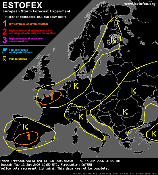
Zwaartepunt blijft gelijk met vandaag.
Northern France, Benelux
Focus of expected potential for organized convection will be southeastern quadrant of developing cut-off low over British Isles. Increasing DLS is forecast at the southern edge of the cut-off low ... and DCVA is expected to spread southward. At lower levels ... well-developed frontal boundary should spread southward, too ... leading to low-level stabilization near the channel region ... while boundary-layer convergence should reach central France in the evening hours. North of the frontal boundary ... model outout shows rather warm/moist boundary-layer ... and CAPE should be present. Given QG forcing ... showers and thunderstorms are forecast to develop along the cold front and especially to the north of it. Convection may start elevated due to stable low layers ... but is expected to root to the boundary layer that is forecast to be moist/warm. Given easterly surface winds north of the frontal boundary ... and westerly jet aloft ... yielding DLS of 20 m/s and veering profiles ... thunderstorms will likely organize into multicells and mesocyclones ... capable of producing isolated large hail and severe wind gusts. An upgrade to level 2 may be warrant when thermodynamic profiles will evolve better than anticipated. Later in the day ... thunderstorms are expected to merge into an MCS moving eastwards into Benelux with severe wind gusts the most significant threat. While shear profiles weaken ... cluster of storms should also weaken during the night hours. Along the surface boundary over central France ... additional convection should form. Given weak DLS ... storms should be outflow-dominant ... forming a cluster. Given well-mixed low-levels ... severe wind gusts should be possible.
GATZEN
Northern France, Benelux
Focus of expected potential for organized convection will be southeastern quadrant of developing cut-off low over British Isles. Increasing DLS is forecast at the southern edge of the cut-off low ... and DCVA is expected to spread southward. At lower levels ... well-developed frontal boundary should spread southward, too ... leading to low-level stabilization near the channel region ... while boundary-layer convergence should reach central France in the evening hours. North of the frontal boundary ... model outout shows rather warm/moist boundary-layer ... and CAPE should be present. Given QG forcing ... showers and thunderstorms are forecast to develop along the cold front and especially to the north of it. Convection may start elevated due to stable low layers ... but is expected to root to the boundary layer that is forecast to be moist/warm. Given easterly surface winds north of the frontal boundary ... and westerly jet aloft ... yielding DLS of 20 m/s and veering profiles ... thunderstorms will likely organize into multicells and mesocyclones ... capable of producing isolated large hail and severe wind gusts. An upgrade to level 2 may be warrant when thermodynamic profiles will evolve better than anticipated. Later in the day ... thunderstorms are expected to merge into an MCS moving eastwards into Benelux with severe wind gusts the most significant threat. While shear profiles weaken ... cluster of storms should also weaken during the night hours. Along the surface boundary over central France ... additional convection should form. Given weak DLS ... storms should be outflow-dominant ... forming a cluster. Given well-mixed low-levels ... severe wind gusts should be possible.
GATZEN