Hallo,
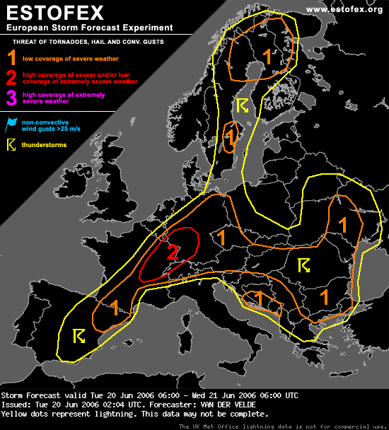
Estofax verwacht vanavond erg zwaar weer met mogelijk "supercells", ten ZO ( zie plaatje )
Luxemburg valt nog onder zone 2 !
DISCUSSION
...Northeastern France into northern Switzerland and southwestern Germany...
A level 2 has been issued, meaning a threat of widespread severe weather, and the possibility of isolated extreme weather. As a shortwave through moves through the area it will cause widespread convection.
The strong midlevel winds, described above, would generate 15-20 m/s deep-layer shear (0-6 km), while SREH will surge to values over
100 m2/s2 over a large area, possibly >250 m2/s2 over a smaller area. These numbers are equal or better than we have seen yesterday, which proved to be sufficient for supercells. More supercells, with a capability of producing isolated large or perhaps extremely large hail and severe gusts will be likely today. There is an increased threat of tornadoes, because the low-level (0-1 km) shear reaches over 10 m/s, in combination with LCLs not too high, between 1000-1500 m.
As convection is expected to coagulate into a rapidly moving MCS (squall line with bow echoes) towards or during the evening, the threat of especially widespread severe gusts will increase.
Estofax verwacht vanavond erg zwaar weer met mogelijk "supercells", ten ZO ( zie plaatje )
Luxemburg valt nog onder zone 2 !
DISCUSSION
...Northeastern France into northern Switzerland and southwestern Germany...
A level 2 has been issued, meaning a threat of widespread severe weather, and the possibility of isolated extreme weather. As a shortwave through moves through the area it will cause widespread convection.
The strong midlevel winds, described above, would generate 15-20 m/s deep-layer shear (0-6 km), while SREH will surge to values over
100 m2/s2 over a large area, possibly >250 m2/s2 over a smaller area. These numbers are equal or better than we have seen yesterday, which proved to be sufficient for supercells. More supercells, with a capability of producing isolated large or perhaps extremely large hail and severe gusts will be likely today. There is an increased threat of tornadoes, because the low-level (0-1 km) shear reaches over 10 m/s, in combination with LCLs not too high, between 1000-1500 m.
As convection is expected to coagulate into a rapidly moving MCS (squall line with bow echoes) towards or during the evening, the threat of especially widespread severe gusts will increase.
3D-wolken en 3D-bliksemfotografie

 .
.