 .!
.!
SYNOPSIS
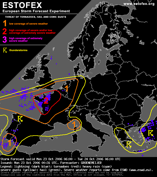
Most active convective weather is expected across western parts of Europe in the range of a strong southwesterly jet. A fairly compact surface cyclone is expected to move ENEward and reach Normandy around 00 UTC. Warm air is advected northward ahead of the system with a strengthening low-level jet.
France, SErn UK, Benelux...
During the morning and afternoon a strong SWly jet over the area creates strong 25-35 m/s deep-layer shear across western France and around 15 m/s 0-1 km shear. As a result, a chance of rotating storms/supercells will exist.
Near an upper cold front - the leading edge of a dry intrusion - that moves northeastward over western and northwestern France in the late morning and afternoon storm-relative helicity is locally enhanced. A few 100's of J/kg are expected to be available. The enhanced SRH implies a locally enhanced threat of supercells will exist there with an attendant threat of tornadoes. The system and attendant threat of supercells/tornadoes should move into the SErn UK and the Benelux countries in the evening. Threat will however decrease somewhat as models suggest that instability should gradually become weaker.
Surface winds should gradually veer a few hours after passage of the upper cold front, implying adecreasing chance of rotating storms. Over southwestern France, surface winds will likely remain backed in the lee of the Pyrenees, especially on the approach of the low pressure system during the afternoon and evening. As a result, conditions for rotating storms and a tornado/hail threat may persist there into the evening.
Increasing low-level flow to over 30 m/s at 850 hPa and destabilisation ahead of the primary upper trough suggests squall-lines producing rather widespread severe wind gusts will move northeastward across western and northern France into the Benelux countries.
