DISCUSSION
... E France ... Benelux ... W Germany ...
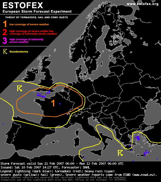
Current indications are that linear and potentially severe convection will develop along the cold front reaching France late Saturday night. This system will affect W Germany and the Benelux States early in the period, and given that strong large-scale forcing for vertical motion will remain in place, CAPE should be maintained in the potentially unstable air mass. This is also supported by the latest GFS run. Shear will remain adequate for severe wind gusts due mainly to vertical momentum transfer, though an isolated tornado or two could also occur given ample low-level shear. However, considering the strong tendency of the low-level thermal structure of the front to weaken, convective activity may well be in a weakening trend as well, as it reaches W Germany and the Benelux States Sunday morning/midday. Nonetheless, a level one threat will be introduced.
Given a period of nearly 24h of the present baroclinic waves ... very similar scenario to that of Saturday night is likely to unfold early Monday morning again over NW France the SW parts of the UK. Some uncertainty exists with the timing/placement of the associated cold front, with BOLAM moving it rather fast eastwards, reaching E France by Monday 06Z, while GFS 00Z and GFS 06Z are somewhat slower, placing it over the central/western portions of France by Monday 06Z. Potential exists for another round of strongly forced/linear convection capable of widespread severe wind gusts and a few tornadoes.
Otherwise ... severe threat should be rather low, though isolated waterspouts may occur with the convection over the Mediterranean.
... E France ... Benelux ... W Germany ...
Current indications are that linear and potentially severe convection will develop along the cold front reaching France late Saturday night. This system will affect W Germany and the Benelux States early in the period, and given that strong large-scale forcing for vertical motion will remain in place, CAPE should be maintained in the potentially unstable air mass. This is also supported by the latest GFS run. Shear will remain adequate for severe wind gusts due mainly to vertical momentum transfer, though an isolated tornado or two could also occur given ample low-level shear. However, considering the strong tendency of the low-level thermal structure of the front to weaken, convective activity may well be in a weakening trend as well, as it reaches W Germany and the Benelux States Sunday morning/midday. Nonetheless, a level one threat will be introduced.
Given a period of nearly 24h of the present baroclinic waves ... very similar scenario to that of Saturday night is likely to unfold early Monday morning again over NW France the SW parts of the UK. Some uncertainty exists with the timing/placement of the associated cold front, with BOLAM moving it rather fast eastwards, reaching E France by Monday 06Z, while GFS 00Z and GFS 06Z are somewhat slower, placing it over the central/western portions of France by Monday 06Z. Potential exists for another round of strongly forced/linear convection capable of widespread severe wind gusts and a few tornadoes.
Otherwise ... severe threat should be rather low, though isolated waterspouts may occur with the convection over the Mediterranean.


 ).
).