PRESS RELEASE: Arctic Sea Ice Narrowly Misses Wintertime Record Low
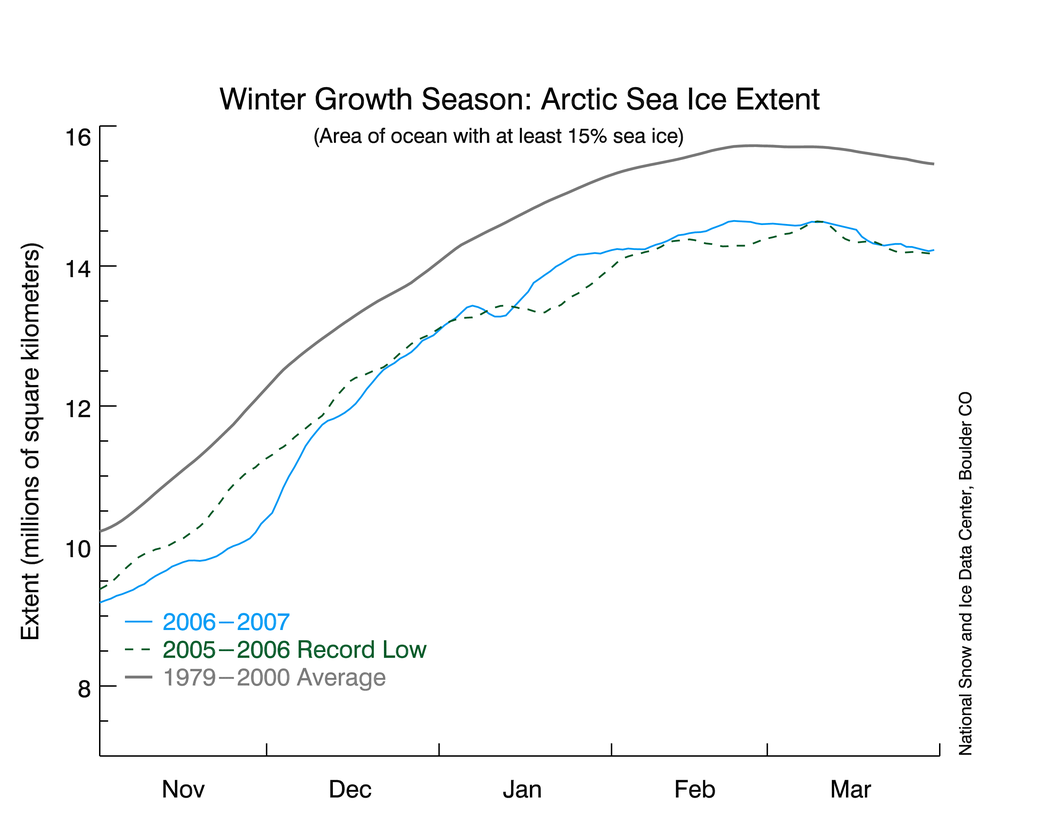
Figure 1. Winter Arctic sea ice grows during the winter months, usually peaking in late March. March 2007, shown in a solid blue line, was the second-lowest in the satellite record. High-resolution version graph showing long-term mean, record year, and 2007 Arctic sea ice for winter ending in March
NSIDC scientists announced that the winter 2007 Arctic sea ice maximum was the second-lowest in the satellite record, narrowly missing the March 2006 record (see Figure 1).
Sea ice extent, or the area of ocean that is covered by at least 15 percent ice, was 14.7 million square kilometers (5.7 million square miles) for March 2007, compared to 14.5 million square kilometers (5.6 million square miles) for March 2006, the current record (see Figure 2). The long-term monthly mean for March sea ice extent from 1979 to 2000 is 15.7 million square kilometers (6.1 million square miles).
Scientists monitor the sea ice year-round, paying special attention to extent during March and September. March usually marks the end of winter in the Arctic, a period when sea ice grows, or recovers, from the summer minimum. Low winter recovery means that the ice is freezing up later in the fall and growing at a slower pace in the winter. September usually marks the end of the summer melting season; low summer extent means that ice is melting faster during the summer and leaving less ice to build on during winter recovery.
NSIDC scientist Walt Meier said, "This year's low wintertime extent is another milestone in a strong downward trend. We're still seeing near-record lows and higher-than-normal temperatures. We expect the downward trend to continue in future years."
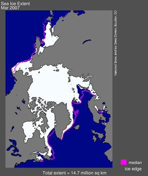
Figure 2. The pink line indicates the 1979–2000 mean sea ice extent in winter; March 2007 ice extent is indicated by the solid off-white area. Land masses are in green; water is in dark blue. Source: NSIDC Sea Ice Index. High-resolution version satellite image of Arctic showing sea ice and landmasses and oceans, with a line delineating long-term mean
For more information on summer sea ice decline and scientific monitoring of sea ice, see Frequently Asked Questions About Sea Ice.
Groeten,
Wouter
Figure 1. Winter Arctic sea ice grows during the winter months, usually peaking in late March. March 2007, shown in a solid blue line, was the second-lowest in the satellite record. High-resolution version graph showing long-term mean, record year, and 2007 Arctic sea ice for winter ending in March
NSIDC scientists announced that the winter 2007 Arctic sea ice maximum was the second-lowest in the satellite record, narrowly missing the March 2006 record (see Figure 1).
Sea ice extent, or the area of ocean that is covered by at least 15 percent ice, was 14.7 million square kilometers (5.7 million square miles) for March 2007, compared to 14.5 million square kilometers (5.6 million square miles) for March 2006, the current record (see Figure 2). The long-term monthly mean for March sea ice extent from 1979 to 2000 is 15.7 million square kilometers (6.1 million square miles).
Scientists monitor the sea ice year-round, paying special attention to extent during March and September. March usually marks the end of winter in the Arctic, a period when sea ice grows, or recovers, from the summer minimum. Low winter recovery means that the ice is freezing up later in the fall and growing at a slower pace in the winter. September usually marks the end of the summer melting season; low summer extent means that ice is melting faster during the summer and leaving less ice to build on during winter recovery.
NSIDC scientist Walt Meier said, "This year's low wintertime extent is another milestone in a strong downward trend. We're still seeing near-record lows and higher-than-normal temperatures. We expect the downward trend to continue in future years."
Figure 2. The pink line indicates the 1979–2000 mean sea ice extent in winter; March 2007 ice extent is indicated by the solid off-white area. Land masses are in green; water is in dark blue. Source: NSIDC Sea Ice Index. High-resolution version satellite image of Arctic showing sea ice and landmasses and oceans, with a line delineating long-term mean
For more information on summer sea ice decline and scientific monitoring of sea ice, see Frequently Asked Questions About Sea Ice.
Groeten,
Wouter