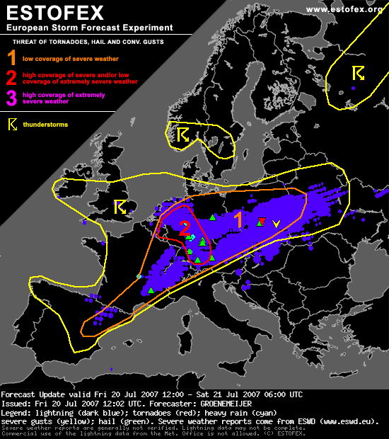
ESTOFEX had trouwens een level-1 voor Polen, maar...
Bericht van: Alwin (Zeist-West) , 23-07-2007 23:06
...eerlijk is eerlijk: tornado's werden voor deze regio helaas niet genoemd, zie de tekst verderop.
De sounding van Wroclaw (ZW-Polen, 14 uur dus enkele uren vóór de tornado) ziet er superinstabiel uit, met een warrig, maar wel duidelijk anticyclonaal gekromd hodogram (zal niet aan het werkelijke windprofiel liggen, de windsnelheidscomponenten zijn trouwens in m/s).
Met Excel kwam ik op een niet al te hoge SREH0-3km van 110 m2/s2 uit, maar gezien de slechte kwaliteit van het hodogram moet deze waarde als een zéér ruwe schatting beschouwd worden.
Met de MLCAPE van 1512 J/kg kom je dan uit op een EHI van ruim 1 (EHI=CAPE*SREH/160000).
Groet,
Alwin
-------------------------------------------
Austria, Czech Republic, Poland ...
Low storm coverage is expected across much of this area at first, as a strong elevated mixed layer should succeed to effectively cap a moist warm boundary layer in most places. During the latter half of the afternoon, however, the cap is forecast to break mostly over west-Central and central Poland, close to the axis of the baroclinic zone. It is however not ruled out at all that this will also occur further south especially near mountain ranges. CAPE values of around 2000 J/kg and deep-layer shear around 15 m/s suggest a substantial severe potential with any storm that forms, mainly consisting of severe downdrafts and large or even very large hail. The low allover coverage and unceratinty about its location however prevents the issuance
of a level 2 at the moment.
-------------------------------------------
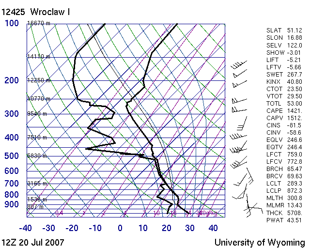
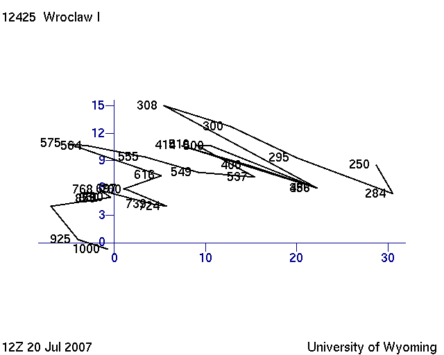
De sounding van Wroclaw (ZW-Polen, 14 uur dus enkele uren vóór de tornado) ziet er superinstabiel uit, met een warrig, maar wel duidelijk anticyclonaal gekromd hodogram (zal niet aan het werkelijke windprofiel liggen, de windsnelheidscomponenten zijn trouwens in m/s).
Met Excel kwam ik op een niet al te hoge SREH0-3km van 110 m2/s2 uit, maar gezien de slechte kwaliteit van het hodogram moet deze waarde als een zéér ruwe schatting beschouwd worden.
Met de MLCAPE van 1512 J/kg kom je dan uit op een EHI van ruim 1 (EHI=CAPE*SREH/160000).
Groet,
Alwin
-------------------------------------------
Austria, Czech Republic, Poland ...
Low storm coverage is expected across much of this area at first, as a strong elevated mixed layer should succeed to effectively cap a moist warm boundary layer in most places. During the latter half of the afternoon, however, the cap is forecast to break mostly over west-Central and central Poland, close to the axis of the baroclinic zone. It is however not ruled out at all that this will also occur further south especially near mountain ranges. CAPE values of around 2000 J/kg and deep-layer shear around 15 m/s suggest a substantial severe potential with any storm that forms, mainly consisting of severe downdrafts and large or even very large hail. The low allover coverage and unceratinty about its location however prevents the issuance
of a level 2 at the moment.
-------------------------------------------
Bericht laatst bijgewerkt: 23-07-2007 23:26

