GG! Wat dacht je van dit ex-tropische-stormhodogram?
Bericht van: Alwin (Zeist-West) , 28-07-2007 20:00
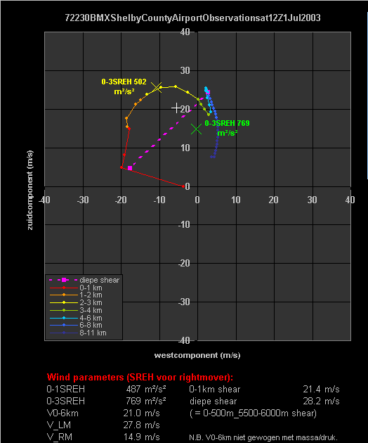
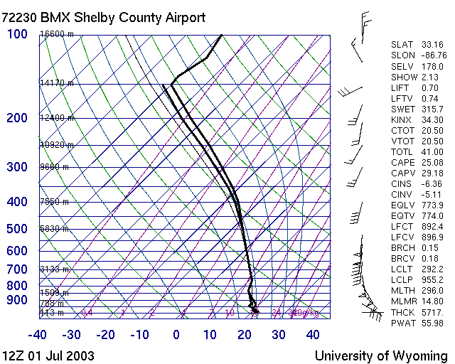
Wow... BMX Shelby County Airport had op 1 juli 2003 om 12 UTC een 0-3SREH van 769 m2/s2, het hodogram is hieronder getoond! (Volgens de bron hieronder zelfs 831 m2/s2, maar ik weet niet welke buibeweging zij hebben gebruikt. Ik gebruik de Bunkers ID methode, waarbij de NIET massagewogen 0-6 km wind als ingrediënt wordt genomen, zoals Bunkers zelf zegt in http://www.crh.noaa.gov/images/unr/soo/scm/SCmotion.ppt.)
Zulke shearwaarden zullen we bij ons wel nooit halen.
Als je trouwens nog bugs ziet, dan hoor ik dat graag! Ik heb er zelf al verscheidene gevonden en heb nu wel behoorlijk vertrouwen in m'n Excelsheet. Ik raad je i.i.g. aan om op http://nlweer.com/xls/sounding.xls de nieuwste versie te downloaden als je ermee aan de slag gaat.
Groet,
Alwin
CHARACTERISTICS OF A TORNADO OUTBREAK ASSOCIATED WITHTHE REMNANTS OF TROPICAL STORM BILL
Paul A. Yura * and Daniel St. Jean NOAA, National Weather Service Forecast Office, Charleston South Carolina 1.
INTRODUCTION
On the night of 1 July 2003 the remnants of Tropical Storm Bill crossed portions of the southeast United States and Southern Appalachians. As these remnants tracked across north Georgia and upstate South Carolina, they produced a small tornado outbreak in sections of east Georgia and southeast South Carolina. Post storm surveys verified 4 F1 tornadoes and 2 F2 tornadoes (NCDC 2003) across the National Weather Service Forecast Office Charleston, South Carolina (CHS) county warning area (CWA; see Fig. 1), making it the largest tropical tornado outbreak in that area since Hurricane Earl took a similar track in 1998. This nighttime outbreak occurred in a low CAPE, highly sheared environment, similar to what has beenfound in previous studies of tropical tornado outbreaks (McCaul 1991). In addition, radar and mesoanalysis discovered several mini supercells which tracked across the region, along with a warm frontal boundary which likely enhanced severe convection. This study will review this tornado outbreak, with an assessment of its synoptic and mesoscale environment within the scope of current and historical research of tornadic events associated with tropical cyclones. A radar analysis of the tornadic storms will show the importance of maintaining situational awareness and monitoring persistent mesocyclones. It will be shown how obtaining current storm relative helicity (SREH) measurements from the VelocityAzimuth Display (VAD) profile can lead to improved and warningdecision making. Future warning improvements will also be discussed.
Zulke shearwaarden zullen we bij ons wel nooit halen.
Als je trouwens nog bugs ziet, dan hoor ik dat graag! Ik heb er zelf al verscheidene gevonden en heb nu wel behoorlijk vertrouwen in m'n Excelsheet. Ik raad je i.i.g. aan om op http://nlweer.com/xls/sounding.xls de nieuwste versie te downloaden als je ermee aan de slag gaat.
Groet,
Alwin
CHARACTERISTICS OF A TORNADO OUTBREAK ASSOCIATED WITHTHE REMNANTS OF TROPICAL STORM BILL
Paul A. Yura * and Daniel St. Jean NOAA, National Weather Service Forecast Office, Charleston South Carolina 1.
INTRODUCTION
On the night of 1 July 2003 the remnants of Tropical Storm Bill crossed portions of the southeast United States and Southern Appalachians. As these remnants tracked across north Georgia and upstate South Carolina, they produced a small tornado outbreak in sections of east Georgia and southeast South Carolina. Post storm surveys verified 4 F1 tornadoes and 2 F2 tornadoes (NCDC 2003) across the National Weather Service Forecast Office Charleston, South Carolina (CHS) county warning area (CWA; see Fig. 1), making it the largest tropical tornado outbreak in that area since Hurricane Earl took a similar track in 1998. This nighttime outbreak occurred in a low CAPE, highly sheared environment, similar to what has beenfound in previous studies of tropical tornado outbreaks (McCaul 1991). In addition, radar and mesoanalysis discovered several mini supercells which tracked across the region, along with a warm frontal boundary which likely enhanced severe convection. This study will review this tornado outbreak, with an assessment of its synoptic and mesoscale environment within the scope of current and historical research of tornadic events associated with tropical cyclones. A radar analysis of the tornadic storms will show the importance of maintaining situational awareness and monitoring persistent mesocyclones. It will be shown how obtaining current storm relative helicity (SREH) measurements from the VelocityAzimuth Display (VAD) profile can lead to improved and warningdecision making. Future warning improvements will also be discussed.
Bericht laatst bijgewerkt: 16-08-2007 01:54