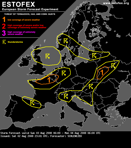
Zo vanaf de lijn kortrijk - gent - antwerpen. Hopelijk een onverwachte update nog dat we hier ook een code 1 hebben 
 .
.
DISCUSSION
...Northern France, Belgium, extreme western Germany...
Advection of warm and moist air should lead to dewpoints around 15°C over France and Belgium during the afternoon and some hundred J/kg of CAPE will form. Although mid levels are quite warm, convective initiation should be warranted as a frontal wave will overspread the region in the evening. Deep layer shear in order of 30 m/s and strong low level winds with 20 m/s at 850hPa in the vicinity of the wave will aid storms to organize into a bowing line, capable of producing severe gusts. Storms at the leading edge of a linear system as well as discrete cells will probably become supercellular as 150 - 200 J/kg SRH3 should be available. Low LCL heights and strong LLS support an isolated tornado as well. Despite meager CAPE, a level-one threat is warranted.
.DISCUSSION
...Northern France, Belgium, extreme western Germany...
Advection of warm and moist air should lead to dewpoints around 15°C over France and Belgium during the afternoon and some hundred J/kg of CAPE will form. Although mid levels are quite warm, convective initiation should be warranted as a frontal wave will overspread the region in the evening. Deep layer shear in order of 30 m/s and strong low level winds with 20 m/s at 850hPa in the vicinity of the wave will aid storms to organize into a bowing line, capable of producing severe gusts. Storms at the leading edge of a linear system as well as discrete cells will probably become supercellular as 150 - 200 J/kg SRH3 should be available. Low LCL heights and strong LLS support an isolated tornado as well. Despite meager CAPE, a level-one threat is warranted.