 !!
!!
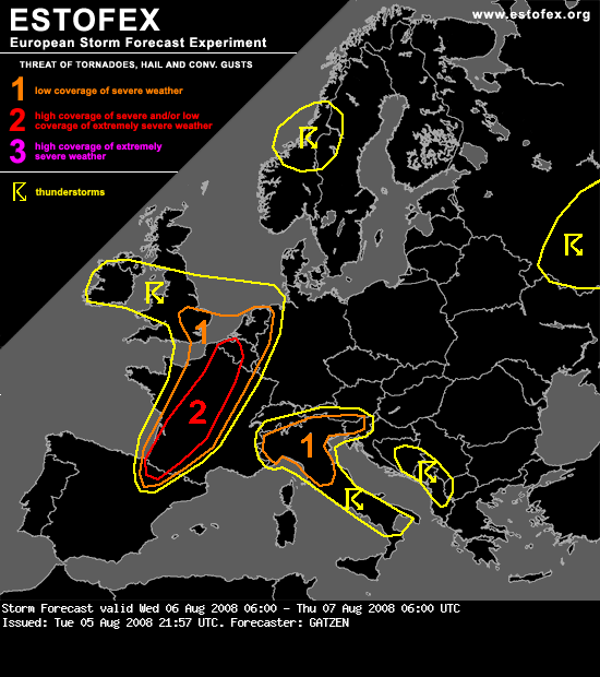
Parts of France, Belgium, the Netherlands, north-western Germany
Quite warm EML will spread across France east of the propagating trough. 850 hPa temperature is expected to reach around 20°C over central France in the afternoon hours. Given quite dry and relatively cool boundary-layer, a strong capping inversion will likely suppress deep convection most of the day except of some thunderstorms that are forecast along a warm front near the North Sea that will likely be elevated due to the cool boundary-layer. In the evening hours, upper height falls are forecast over western and northern France in the range of the propagating upper trough. Models also indicate that some QG forcing will result in low surface pressure over central France, and moisture flux convergence is forecast to lead to rich boundary-layer moisture from south-western France to central France in the evening hours, leading to CAPE values in the order of 1500 J/kg. In the evening hours, a cold front will move south-eastwards into north-western and western France, and thunderstorms will likely develop along this front, spreading north-eastwards. Thunderstorms that form will likely evolve into supercells given strong vertical wind shear and favorable veering profiles. 0-3 km vertical wind shear will be in the 10-15 m/s rage ahead of the approaching cold front in the evening hours. Large hail and severe wind gusts are expected to be the most significant threat. Thunderstorms may merge into a linear MCS ahead of the cold front given quite intense cold pools. Thunderstorms will likely spread into central France during the night hours, while severe threat is expected to remain. To the north, low-level moisture development is more questionable. However, it seems that quite strong QG forcing evolves at the northern edge of a tongue of warm air mass spreading northward just east of the approaching cold front. This will likely result in convective initiation to the north of the surface low located over central France in the evening hours. Strong vertical wind shear will be present and supercells are forecast, capable of producing large hail and severe wind gusts.An isolated tornado is not ruled out from northern France to Belgium and the Netherlands, where locally favorable veering profiles may materialize in the range of the warm front. Latest models indicate that the best potential may be present over Belgium, where strong southerly low-level jet is forecast in the evening/night hours. Thunderstorms will likely merge into an MCS moving north-eastwards along the North Sea coast into north-western Germany, while right-moving clustering storms will likely spread into western Germany in the night hours. Severe threat is expected to weaken given limited instability, but severe wind gusts are not ruled out along the leading gust front.
Quite warm EML will spread across France east of the propagating trough. 850 hPa temperature is expected to reach around 20°C over central France in the afternoon hours. Given quite dry and relatively cool boundary-layer, a strong capping inversion will likely suppress deep convection most of the day except of some thunderstorms that are forecast along a warm front near the North Sea that will likely be elevated due to the cool boundary-layer. In the evening hours, upper height falls are forecast over western and northern France in the range of the propagating upper trough. Models also indicate that some QG forcing will result in low surface pressure over central France, and moisture flux convergence is forecast to lead to rich boundary-layer moisture from south-western France to central France in the evening hours, leading to CAPE values in the order of 1500 J/kg. In the evening hours, a cold front will move south-eastwards into north-western and western France, and thunderstorms will likely develop along this front, spreading north-eastwards. Thunderstorms that form will likely evolve into supercells given strong vertical wind shear and favorable veering profiles. 0-3 km vertical wind shear will be in the 10-15 m/s rage ahead of the approaching cold front in the evening hours. Large hail and severe wind gusts are expected to be the most significant threat. Thunderstorms may merge into a linear MCS ahead of the cold front given quite intense cold pools. Thunderstorms will likely spread into central France during the night hours, while severe threat is expected to remain. To the north, low-level moisture development is more questionable. However, it seems that quite strong QG forcing evolves at the northern edge of a tongue of warm air mass spreading northward just east of the approaching cold front. This will likely result in convective initiation to the north of the surface low located over central France in the evening hours. Strong vertical wind shear will be present and supercells are forecast, capable of producing large hail and severe wind gusts.An isolated tornado is not ruled out from northern France to Belgium and the Netherlands, where locally favorable veering profiles may materialize in the range of the warm front. Latest models indicate that the best potential may be present over Belgium, where strong southerly low-level jet is forecast in the evening/night hours. Thunderstorms will likely merge into an MCS moving north-eastwards along the North Sea coast into north-western Germany, while right-moving clustering storms will likely spread into western Germany in the night hours. Severe threat is expected to weaken given limited instability, but severe wind gusts are not ruled out along the leading gust front.
Bericht laatst bijgewerkt: 06-08-2008 00:08