Storm Forecast
Valid: Tue 12 Aug 2008 11:00 to Thu 14 Aug 2008 06:00 UTC
Issued: Tue 12 Aug 2008 11:30
Forecaster: GROENEMEIJER
Ahead of the surface cold front, surface winds are generally between south and southeast, which creates 100-250 m2/s2 of 0-3 km storm relative helicity. About 500-1000 J/kg of surface-based CAPE is expected here. Strong deep-layer (0-6 km bulk) shear of 25-35 m/s should create an environment conducive to updraft rotation. Relatively high near-surface buoyancy release for surface parcels will probably support low-level rotation as well.
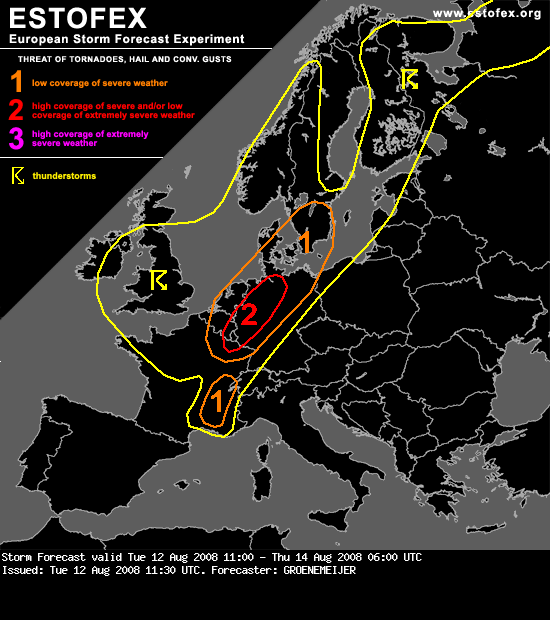
Rotating storms have already been observed by Doppler radar across NE Belgium and SE Netherlands. Further development of a number of small supercells capable of producing tornadoes, possibly including a few strong ones (F2/F3) are expected across the SE Benelux, Lorraine, the Rhineland, Northrhine-Westphalia and Lower Saxony, before moving to north-central parts of Germany later today. Additionally, isolated large hail and some strong/severe straight-line winds are expected.
Valid: Tue 12 Aug 2008 11:00 to Thu 14 Aug 2008 06:00 UTC
Issued: Tue 12 Aug 2008 11:30
Forecaster: GROENEMEIJER
Ahead of the surface cold front, surface winds are generally between south and southeast, which creates 100-250 m2/s2 of 0-3 km storm relative helicity. About 500-1000 J/kg of surface-based CAPE is expected here. Strong deep-layer (0-6 km bulk) shear of 25-35 m/s should create an environment conducive to updraft rotation. Relatively high near-surface buoyancy release for surface parcels will probably support low-level rotation as well.
Rotating storms have already been observed by Doppler radar across NE Belgium and SE Netherlands. Further development of a number of small supercells capable of producing tornadoes, possibly including a few strong ones (F2/F3) are expected across the SE Benelux, Lorraine, the Rhineland, Northrhine-Westphalia and Lower Saxony, before moving to north-central parts of Germany later today. Additionally, isolated large hail and some strong/severe straight-line winds are expected.
Bericht laatst bijgewerkt: 12-08-2008 13:56