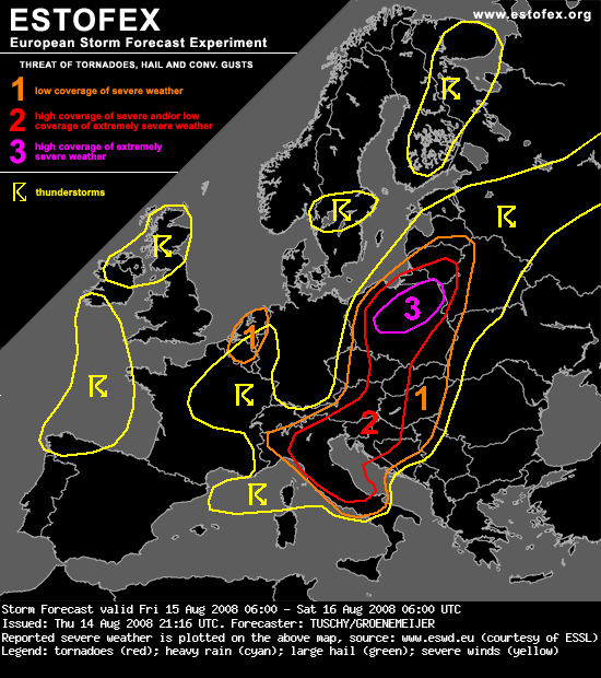
Level 3.. link en verwachting :polen + lvl1 belgie/nederland
Bericht van: Miguel (Varsenare) , 14-08-2008 23:29
...Poland...
The aforementioned wavy frontal boundary will get modified by the developing surface depression over Poland and is expected to move northward across Poland as a warm front. Cold air slowly advances from the W during the evening/night hours. The warm sector, which covers most parts of Poland, is characterized by a warm boundary-layer with dewpoints near 20°C in vicinity of the frontal zones. Shear along the warm front and next to the depression's center should increase during the day with locally up to 20 m/s low-level shear and 0-1 km storm-relative helicity values of more than 300 m^2/s^2. LCL heights should be low near and just north of the warm front. Each thunderstorm that develops near this boundary has a high chance to acquire strong low-level rotation and produce strong tornadoes. During the late afternoon hours, the low-level wind field increases even further with readings of more than 25 m/s at 850 hPa. This not only increases the risk of rotating storms, but enhances the risk for damaging wind gusts as well. Numerical models suggest that storms may cluster across central and/or northern Poland and subsequently move northeastward into Lithuania and further northeastward. If such a cluster develops, it could well develop into a bow echo with widespread damaging winds. In comparison with the Extended Forecast issued earlier, we have upgraded parts of the area to a level 3 because a regional tornado outbreak appears very well possible in addition to damaging wind gusts.
Both shear and instability values are also impressive over SW Poland, but directional shear should be much weaker. This should help to abate the tornado risk, but storms moving off the hodograph could still produce tornadoes. The main risk will be a severe-damaging wind gust and isolated large hail threat as shear at the lowest 3km increases to 25m/s.
...Belgium and the Netherlands...
Placed under the broad upper trough axis, cold mid-/upper levels will support deep convection during the midday/afternoon hours. Shear is very weak, but there will be some CAPE release in the lowest 3 km and hence a few funnel/tornado/waterspout events can occur. A marginal level 1 was therefore introduced. Thunderstorm activity and coverage should decrease after sunset.
The aforementioned wavy frontal boundary will get modified by the developing surface depression over Poland and is expected to move northward across Poland as a warm front. Cold air slowly advances from the W during the evening/night hours. The warm sector, which covers most parts of Poland, is characterized by a warm boundary-layer with dewpoints near 20°C in vicinity of the frontal zones. Shear along the warm front and next to the depression's center should increase during the day with locally up to 20 m/s low-level shear and 0-1 km storm-relative helicity values of more than 300 m^2/s^2. LCL heights should be low near and just north of the warm front. Each thunderstorm that develops near this boundary has a high chance to acquire strong low-level rotation and produce strong tornadoes. During the late afternoon hours, the low-level wind field increases even further with readings of more than 25 m/s at 850 hPa. This not only increases the risk of rotating storms, but enhances the risk for damaging wind gusts as well. Numerical models suggest that storms may cluster across central and/or northern Poland and subsequently move northeastward into Lithuania and further northeastward. If such a cluster develops, it could well develop into a bow echo with widespread damaging winds. In comparison with the Extended Forecast issued earlier, we have upgraded parts of the area to a level 3 because a regional tornado outbreak appears very well possible in addition to damaging wind gusts.
Both shear and instability values are also impressive over SW Poland, but directional shear should be much weaker. This should help to abate the tornado risk, but storms moving off the hodograph could still produce tornadoes. The main risk will be a severe-damaging wind gust and isolated large hail threat as shear at the lowest 3km increases to 25m/s.
...Belgium and the Netherlands...
Placed under the broad upper trough axis, cold mid-/upper levels will support deep convection during the midday/afternoon hours. Shear is very weak, but there will be some CAPE release in the lowest 3 km and hence a few funnel/tornado/waterspout events can occur. A marginal level 1 was therefore introduced. Thunderstorm activity and coverage should decrease after sunset.