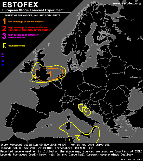
Wales, England, Netherlands...
After the passage of a first frontal system late on Saturday, the British Isles find themselves in relatively cool air initially. At the same time a strong westerly mid- and upper-level flow is located over the area. A distinct speed maximum should approach from the west during the morning per the latest GFS run. A small baroclinic wave is expected to develop in its left exit quadrant and should translate across the British Isles during Sunday afternoon and evening. As a result, boundary layer moisture values of around 7 g/kg are briefly advected back into southern England. The low level winds on the warm side of the developing wave are projected to increase 30-35 m/s at 850 hPa.
A zone of convective precipitation is produced by the GFS, with the suggestion of a convective rainband along the "instant cold front" trailing the "instant warm sector". This zone would move eastward across Wales in the late morning, across much of England during the afternoon and early evening, and finally across the Low Countries.
Ahead of this zone, about 300 m2/s2 0-1 km SREH is forecast, suggesting such a convective line will likely feature small-scale bows and imbedded mesovortices. Some threat for severe convectively-enhanced gusts and a few tornadoes will therefore be present. The exact intensity of the event depends strongly on the extent of wave development.
After the passage of a first frontal system late on Saturday, the British Isles find themselves in relatively cool air initially. At the same time a strong westerly mid- and upper-level flow is located over the area. A distinct speed maximum should approach from the west during the morning per the latest GFS run. A small baroclinic wave is expected to develop in its left exit quadrant and should translate across the British Isles during Sunday afternoon and evening. As a result, boundary layer moisture values of around 7 g/kg are briefly advected back into southern England. The low level winds on the warm side of the developing wave are projected to increase 30-35 m/s at 850 hPa.
A zone of convective precipitation is produced by the GFS, with the suggestion of a convective rainband along the "instant cold front" trailing the "instant warm sector". This zone would move eastward across Wales in the late morning, across much of England during the afternoon and early evening, and finally across the Low Countries.
Ahead of this zone, about 300 m2/s2 0-1 km SREH is forecast, suggesting such a convective line will likely feature small-scale bows and imbedded mesovortices. Some threat for severe convectively-enhanced gusts and a few tornadoes will therefore be present. The exact intensity of the event depends strongly on the extent of wave development.