Gaat daar aardig spoken komende nacht/morgen.
Die randstoring zit lekker goed daar.
Dichter bij de hoge druk, en door dat drukverschil zal de wind daar niet meevallen.
Het nieuws gaan ze wel halen denk ik!
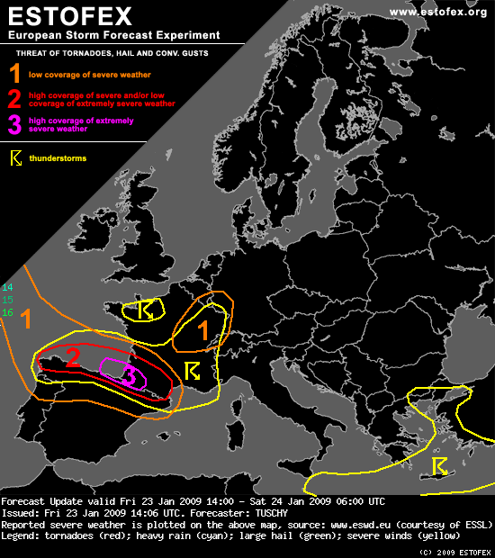
NW-Spain was included into the level-2 as the active cold front passes by and severe to damaging winds mix down to the surface. This risk continues eastwards along the cold front.
The SE Bay of Biscay and parts of SW-France were upgraded as the environment becomes supportive for an organized line of storms, crossing the level-3 area from the west at 00Z onwards. A combination of an eastward moving, intense vorticity lobe beneath aforementioned dry slot and the cold front itself should assist in the development of some moderate instability and a squalline, probably possessing a line echo wave pattern, is forecast. Forecast soundings (GFS) also indicate abundant CAPE release between 750-500hPa, also increasing below 3km. The main threat will be a widespread damaging wind gust risk with this line of storms as convective gusts likely exceed 33m/s. Otherwise, LCLs around 600m, LL shear of 25-30m/s, aforementioned LL CAPE release and intense directional shear also point to a significant tornado risk and strong tornadoes are possible.
Between 03Z-06Z, attention also turns to the approaching occlusion. As a result of the slow down and the earlier occlusion process of the depression, the back-bent occlusion now remains more displaced to the north, affecting the region around Bordeaux. Deep convection is likely with that activity as mid-/upper levels cool down and a sharp north-south wind shear gradient sets-up. Strong directional shear just onshore persists, so tornadoes and severe wind gusts are possible, especially if this occlusion runs a bit more to the south than currently thought. The risk continues after 06Z.
Bron: www.estofex.org
Die randstoring zit lekker goed daar.
Dichter bij de hoge druk, en door dat drukverschil zal de wind daar niet meevallen.
Het nieuws gaan ze wel halen denk ik!
NW-Spain was included into the level-2 as the active cold front passes by and severe to damaging winds mix down to the surface. This risk continues eastwards along the cold front.
The SE Bay of Biscay and parts of SW-France were upgraded as the environment becomes supportive for an organized line of storms, crossing the level-3 area from the west at 00Z onwards. A combination of an eastward moving, intense vorticity lobe beneath aforementioned dry slot and the cold front itself should assist in the development of some moderate instability and a squalline, probably possessing a line echo wave pattern, is forecast. Forecast soundings (GFS) also indicate abundant CAPE release between 750-500hPa, also increasing below 3km. The main threat will be a widespread damaging wind gust risk with this line of storms as convective gusts likely exceed 33m/s. Otherwise, LCLs around 600m, LL shear of 25-30m/s, aforementioned LL CAPE release and intense directional shear also point to a significant tornado risk and strong tornadoes are possible.
Between 03Z-06Z, attention also turns to the approaching occlusion. As a result of the slow down and the earlier occlusion process of the depression, the back-bent occlusion now remains more displaced to the north, affecting the region around Bordeaux. Deep convection is likely with that activity as mid-/upper levels cool down and a sharp north-south wind shear gradient sets-up. Strong directional shear just onshore persists, so tornadoes and severe wind gusts are possible, especially if this occlusion runs a bit more to the south than currently thought. The risk continues after 06Z.
Bron: www.estofex.org
Bericht laatst bijgewerkt: 23-01-2009 17:12

