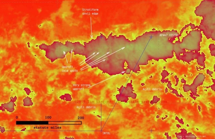
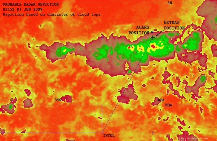
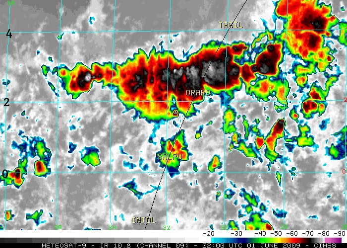
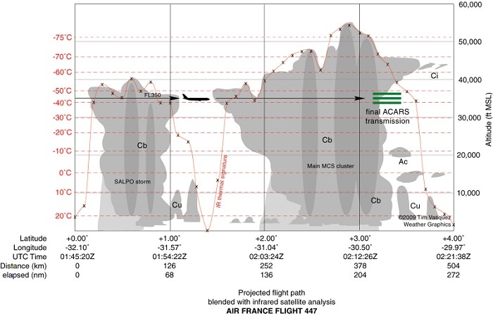
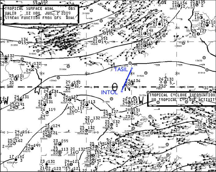
Ja dit was natuurlijk al enkele dagen bekend, maar hier zijn enkele 'beelden' van het ruige weer waar het vliegtuig doorvloog. De lijn stelt de route voor die de AF vlucht heeft gevolgd, en het laatst punt op die lijn is het punt waar de laatste keer teken van leven geweest it van de AF vlucht. Je kan zien dat die 'probleemloos' door een eerste onweder geraakt is, maar het MCS heeft hem de das omgedaan. Let ook op de felle updraft dat de Airbus A330-200 gepasseerd is aan het begin van het MCS. Ik vond het niet OT-waardig omdat dit tenslotte toch over het weer gaat he 
Er zijn speculaties over wat nu de reden van de crash zou zijn.
Afbeeldingen: (meeste zijn copyright Tim Vasquez)
Mvg,
Bart De Bruyn
Er zijn speculaties over wat nu de reden van de crash zou zijn.
Afbeeldingen: (meeste zijn copyright Tim Vasquez)
Conclusions
I've edited this section Monday night to cut down on the speculation about the accident chain, especially since I don't know a whole lot about A330 systems. The airliners.net board and other sites cover the aircraft, CRM, and systems quite well. What I will try to do, however, is summarize what the aircraft probably encountered based on the data and my own experience.
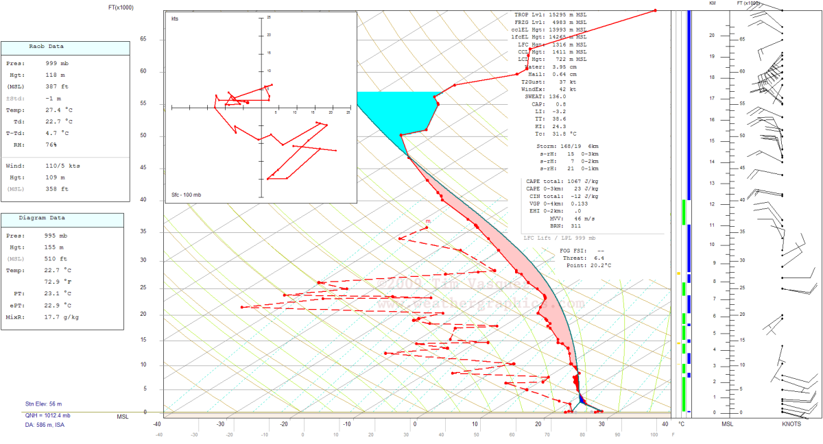
* Turbulence -- As of June 4, I still consider turbulence to be one of the prime factors. Extensive reanalysis of upper level data supports instability values of about 1100 J/kg, which is sufficient to be a danger to airline operations. Though commercial aircraft benefit greatly from airborne radar, these radar units detect mainly rain and hail. Updrafts, particularly if they are strong, may form what are referred to as "weak echo regions" and this can create highly turbulent areas which are not detectable on radar. Another concern is the extensive upper-level dry air shown on the SBFN sounding (not counting the anvil debris at 350-300 mb), which may have contributed to enhanced evaporative cooling around the margins of the anvil clouds and aggravated the turbulence experienced by the flight around the periphery of the storm. It is worth considering that cumulative periods of heavy turbulence crossing through the cluster may have caused minor internal damage that progressed in some way into an emergency.
* Icing -- With a flight level temperature of -40 deg C suggested by the proximity sounding the A330 would have been flying mostly in rime ice and possibly some clear ice and graupel. Unbelievably however I neglected to mention the contribution of latent heat, which would immerse the aircraft in -36 deg C air when crossing atop an updraft. Supercooled water is usually rare at these temperatures (see here for an explanation) though a couple of expert commenters below have presented different views on the subject. And with -36 deg C this increases the risk of graupel, clear ice, and supercooled water brought to FL350. This temperature of -36 deg C represents the absolute maximum temperature that can be expected at FL350 since it is the highest equivalent potential temperature that can be realistically constructed on the sounding.
* Lightning -- Due to the high cloud tops and freezing level at 16,000 ft, there was extensive precipitation by cold rain process and it is likely the MCS was electrified. I have read some claims that lightning detection showed nothing occurring here, and I saw similar indications on the WWLL lightning network, but I believe this is in contradiction with the instability, cold cloud tops, extensive convection, and cold rain process environment associated with this MCS. My belief is that the area is simply too far away from the nearest sferic detection system (Ascension Island). As far what a strike would do to the A330, I have to leave that to to the avionics experts. Some answers might be found at http://www.airliners.net/aviation-forums/.
* Precipitation -- A dual engine flameout due to precipitation or ice ingestion is a noteworthy possibility as has been discussed on other sites (specific to the A330 type too). Due to the high water vapor content in the tropics, tropical weather systems can contain exceptionally high values of precipitable water content. The plane, if at FL350, was experiencing flight level temperatures of between -41 and -36 deg C. Supercooled water is considered to be exceptionally rare or insigificant at temperatures below -30 deg C, but if it does occur it does present the possibility of aggravating airframe and engine icing. Overall the plane was mostly in rime ice and possibly some graupel.
* Hail -- I got a few comments about hail. I am not entirely convinced that structural hail damage is a factor, partly because I can't recall hearing much about large damaging hail at altitude in my experience with equatorial flight operations. This would require strong instability, which I'm not yet sure we have, not only to grow the stones but to loft large hailstones from the embryo "nursery" at FL200-250 up to flight level. A value of 1067 J/kg CAPE is really on the fence but not out of the question. I absolutely do not believe this would support the type of large baseball-size type hail that would be expected to damage an airframe. The other problem is the mounting body of evidence (see SPC studies) suggesting well-sheared storms (this profile is weakly sheared) are the ones conducive to structures that support hail growth. Finally, another issue is airborne radars are highly sensitive to hail because of the strong reflectivity of ice particles, making evasive action likely. The "young updrafts" I pointed out earlier as a threat would not have provided the residence times necessary yet to contain hailstones; their main threat would be severe turbulence. I am not sure about the hail hypothesis, but I believe there is a high probability of graupel, small ice pellets, or small hail at FL350 in the storm complex (see Icing above). Finally one consideration speed is the absolute maximum hailstone size theoretically supported by a 23 m/s updraft (1067 J/kg CAPE) is about 4 cm; the relation is given by Vt=AD^0.5, where D is the diameter in cm, A is an empirical value (about 11.4), and Vt is the fall speed in m/s. If hailstones grow larger than this their terminal fall speed exceeds the updraft speed.
Mvg,
Bart De Bruyn
Weerfoto's op mijn pagina www.facebook.com/madskiesbart