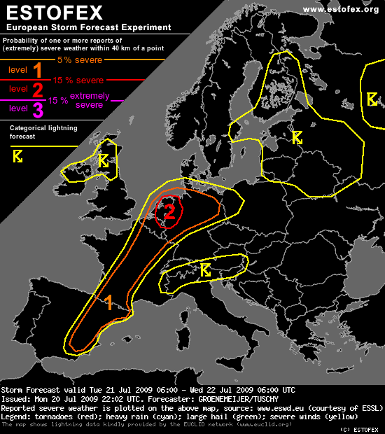
A level 2 was issued for parts of Belgium, the Netherlands and extreme NW-Germany mainly for large hail, severe wind gusts and tornadoes.
----
Benelux, Northern Germany...
An elevated mixed layer covering central and southern France will be advected northeastward during the day and should overspread the Benelux and much of Germany during the afternoon hours. Wind shear will be very strong under the southwesterly jet that consists of two separate speed maxima: one should stretch from north-central Spain across France to NE France, whilst the other is located over the Channel region and SE England. A zone of high, 200-300 m2/s2, storm-relative helicity, should move northward along the leading edge of the elevated mixed layer, and values around 200 m2/s2 should also be locally further south across central and southern France. Moreover, 0-3 km shear will be in the 20-25 m/s range, which is strong.
Models are insofar constistent with each other, that they all produce precipitation in the late afternoon and/or evening across the Benelux and NW Germany, and some further east along the warm front as well. But part of the model produce only little convection. Apparently, the overall forcing for upward motion is not very large.
Still there is confidence that significantly more than just one or two storms will develop. Because of the excellent kinematic and thermodynamic parameters, the have a significant potential to become severe, and a level 2 is issued as a consequence. The storms will likely include supercells. Storms across the Benelux and northern Germany will be capable of producing large hail and damaging gusts, and also tornadoes. The tornado risk will be largest with those cells that tap most of the helical low-level flow: those that ingest the most backed low-level winds.
The storms are expected to continue throughout the evening, and new storms could even develop overnight. However, those will probably be elevated and because of low-level cooling, they will be less likely to produce severe winds or tornadoes.
Gr. Ben
 pompiedom
 .
.
 oh en! Krijgen we een weeralarm?