Vorig jaar hoorde ik voor het eerst van SSW, een erg interessant onderwerp. Al blijkt een SSW absoluut geen garantie voor winterweer bij ons, het is wel erg indrukwekkend verschijnsel.
Toen ik vanavond onderstaande forum las, viel me op dat in de verwachtingen sprake is in ieder geval spannende ontwikkelingen.
http://forum.netweather.tv/topic/57364-stratosphere-temperature-watch/page__st__51
Als reminder heb ik een stuk tekst hier geplaatst over SSW
With the northern hemisphere stratospheric winter beginning to get into full throttle, it is the right time to open a thread dedicated to following the stratospheric temperatures, polar vortex strength and position.
For those who do not know how the stratosphere may influence our weather I will provide a brief guide.
The stratosphere is the layer of the atmosphere situated between 10km and 50km above the earth. It is situated directly above the troposphere, the first layer of the atmosphere that is directly responsible for the weather that we receive. The boundary between the stratosphere and the troposphere is known as the tropopause. The air pressure ranges from around 100hPa at the lower levels to around 1hPa at the upper levels. The middle stratosphere is often considered to be around the 30hPa level.
Every winter the stratosphere cools down dramatically as less solar UV radiation is absorbed by the ozone content in the stratosphere. The difference in the temperature between the North Pole and the latitudes further south creates a strong vortex – the wintertime stratospheric polar vortex. The colder the stratosphere, the stronger this vortex becomes. The stratospheric vortex has a strong relationship with the tropospheric vortex below. The stronger the stratospheric vortex, the stronger the tropospheric vortex becomes.
The strength and position of the tropospheric vortex influences the type of weather that we are likely to experience. A strong polar vortex is more likely to herald a positive AO with the resultant jet stream track bringing warmer wet southwesterly winds. A weaker polar vortex can contribute to a negative AO with the resultant mild wet weather tracking further south.
Occasionally the wintertime stratosphere can undergo dramatic warming events. These are called Sudden Stratospheric Warmings (SSWs) or Major Midwinter Warmings (MMWs). These are caused by large-scale planetary waves being deflected up into the stratosphere and towards the North Pole, often after a strong mountain torque event. These waves can seriously disrupt the stratospheric vortex, leading to a slowing or even reversal of the vortex. This can occur by the vortex being displaced off the pole – a displacement SSW, or by the vortex being split in two – a splitting SSW.
The effects of a SSW can be transmitted into the troposphere as the propagation of the SSW occurs and this can have a number of consequences. There is a higher incidence of northern blocking after SSW’s but (after last winter) we are all aware that not every SSW leads to northern blocking. Last January we experienced a record breaking splitting SSW that was responsible for the pulse of easterly snow some areas received in February (directly from the split) but it did not lead to any major northern blocking.
One major influence on the stratosphere is the Quasi-Biennial Oscillation (QBO). This is a tropical stratospheric wind or gravity pulse that has a rough two year cycle. This wind descends from the top of the stratosphere towards the troposphere in an either westerly or easterly direction. Presently we are in an easterly phase of this wind which is flowing in an opposite direction to the polar vortex flow. It has been shown that an easterly QBO will lead to warming of the stratosphere and therefore this is more favourable in reducing the polar vortex.
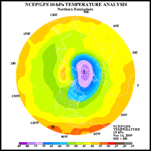
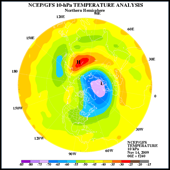
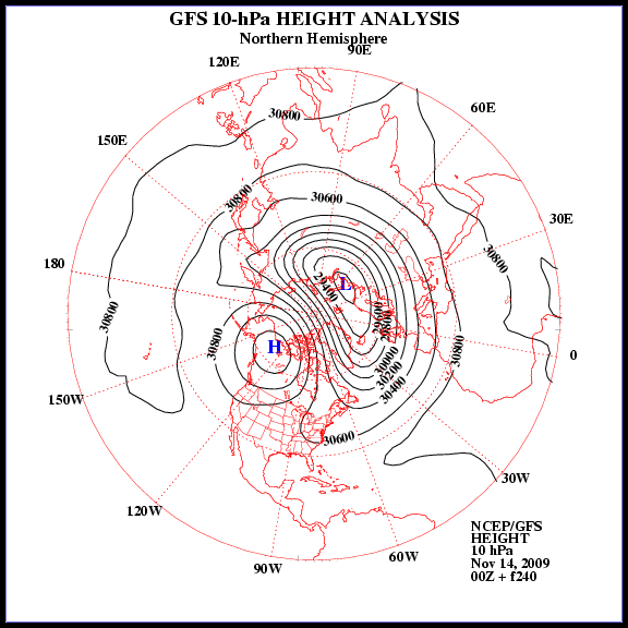
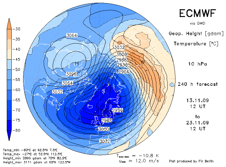
Volgens de meest recente voorspellingen (zaterdagavond 14 november)
Toen ik vanavond onderstaande forum las, viel me op dat in de verwachtingen sprake is in ieder geval spannende ontwikkelingen.
http://forum.netweather.tv/topic/57364-stratosphere-temperature-watch/page__st__51
Als reminder heb ik een stuk tekst hier geplaatst over SSW
With the northern hemisphere stratospheric winter beginning to get into full throttle, it is the right time to open a thread dedicated to following the stratospheric temperatures, polar vortex strength and position.
For those who do not know how the stratosphere may influence our weather I will provide a brief guide.
The stratosphere is the layer of the atmosphere situated between 10km and 50km above the earth. It is situated directly above the troposphere, the first layer of the atmosphere that is directly responsible for the weather that we receive. The boundary between the stratosphere and the troposphere is known as the tropopause. The air pressure ranges from around 100hPa at the lower levels to around 1hPa at the upper levels. The middle stratosphere is often considered to be around the 30hPa level.
Every winter the stratosphere cools down dramatically as less solar UV radiation is absorbed by the ozone content in the stratosphere. The difference in the temperature between the North Pole and the latitudes further south creates a strong vortex – the wintertime stratospheric polar vortex. The colder the stratosphere, the stronger this vortex becomes. The stratospheric vortex has a strong relationship with the tropospheric vortex below. The stronger the stratospheric vortex, the stronger the tropospheric vortex becomes.
The strength and position of the tropospheric vortex influences the type of weather that we are likely to experience. A strong polar vortex is more likely to herald a positive AO with the resultant jet stream track bringing warmer wet southwesterly winds. A weaker polar vortex can contribute to a negative AO with the resultant mild wet weather tracking further south.
Occasionally the wintertime stratosphere can undergo dramatic warming events. These are called Sudden Stratospheric Warmings (SSWs) or Major Midwinter Warmings (MMWs). These are caused by large-scale planetary waves being deflected up into the stratosphere and towards the North Pole, often after a strong mountain torque event. These waves can seriously disrupt the stratospheric vortex, leading to a slowing or even reversal of the vortex. This can occur by the vortex being displaced off the pole – a displacement SSW, or by the vortex being split in two – a splitting SSW.
The effects of a SSW can be transmitted into the troposphere as the propagation of the SSW occurs and this can have a number of consequences. There is a higher incidence of northern blocking after SSW’s but (after last winter) we are all aware that not every SSW leads to northern blocking. Last January we experienced a record breaking splitting SSW that was responsible for the pulse of easterly snow some areas received in February (directly from the split) but it did not lead to any major northern blocking.
One major influence on the stratosphere is the Quasi-Biennial Oscillation (QBO). This is a tropical stratospheric wind or gravity pulse that has a rough two year cycle. This wind descends from the top of the stratosphere towards the troposphere in an either westerly or easterly direction. Presently we are in an easterly phase of this wind which is flowing in an opposite direction to the polar vortex flow. It has been shown that an easterly QBO will lead to warming of the stratosphere and therefore this is more favourable in reducing the polar vortex.
Volgens de meest recente voorspellingen (zaterdagavond 14 november)
„Et nul ne se connait tant qu'il n'a pas souffert, „C'est une dure loi, mais une loi suprème, „Vieille comme le monde et la fatalité, „Qu'l nous faut du malheur regevoir le baptéme, ~Et qu'a ce triste prix tout doit étre acheté. „Les moissons pour murir out besoin de rosée, „Pour vivre et pour sentir l'homme a besoin de pleura, „La joie a pour symbole une plante brisée, „Humide encore de pluie et couverte de fleurs."