ozon (interessante bijdrage op netweather) + vraag
Bericht van: sebastiaan (bussum) , 21-11-2009 13:08
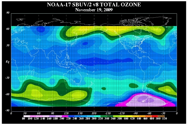
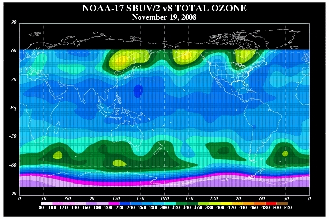
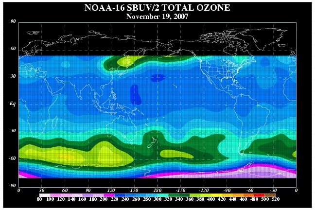
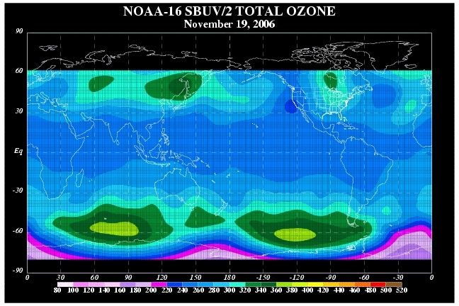
A comparison of total ozone concentrations over mid November during the last decade provides some illuminating insight into how we stand right now and why we are very much better placed to resist the usual drop in stratospheric temperatures as we head into December.
Ozone concentrations more or less translate to stratospheric temperatures, the more ozone the warmer the air and greater the geopotential height anomaly. Also, we need to look at the concentration of ozone over the tropics as less ozone there indicates enhanced Brewer Dobson Circulation activity and a weaker thermal gradient across the hemisphere (weaker polar westerlies - weaker polar vortex).
2002 and 2004 were the closest matches but in both years the tropical stratosphere concentrations were much greater.
With the tropical stratosphere cooling again, this should strengthen ozone concentrations over the Arctic into late December.
A couple of things are very evident looking at these comparisons:
1) The polar vortex will be weaker than any other winter this decade.
2) The position of the ozone concentration has been consistently building over the Pacific. These drift east over time. This means that the most likely place for the warming (and tropospheric impacts) look like starting over the Canadan Arctic and migrating eastwards towards Greenland with a trough over Scandinavia and western Russia.
Wat ik me afvraag wat het uitmaakt waar de opwarming plaats vindt. Is daar iets over bekend?
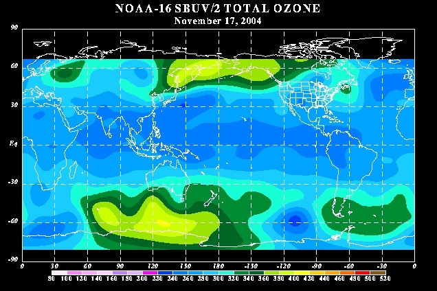
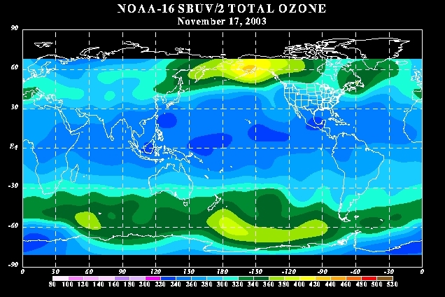
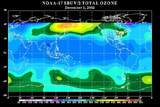
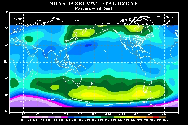
Ozone concentrations more or less translate to stratospheric temperatures, the more ozone the warmer the air and greater the geopotential height anomaly. Also, we need to look at the concentration of ozone over the tropics as less ozone there indicates enhanced Brewer Dobson Circulation activity and a weaker thermal gradient across the hemisphere (weaker polar westerlies - weaker polar vortex).
2002 and 2004 were the closest matches but in both years the tropical stratosphere concentrations were much greater.
With the tropical stratosphere cooling again, this should strengthen ozone concentrations over the Arctic into late December.
A couple of things are very evident looking at these comparisons:
1) The polar vortex will be weaker than any other winter this decade.
2) The position of the ozone concentration has been consistently building over the Pacific. These drift east over time. This means that the most likely place for the warming (and tropospheric impacts) look like starting over the Canadan Arctic and migrating eastwards towards Greenland with a trough over Scandinavia and western Russia.
Wat ik me afvraag wat het uitmaakt waar de opwarming plaats vindt. Is daar iets over bekend?
Bericht laatst bijgewerkt: 21-11-2009 13:09
„Et nul ne se connait tant qu'il n'a pas souffert, „C'est une dure loi, mais une loi suprème, „Vieille comme le monde et la fatalité, „Qu'l nous faut du malheur regevoir le baptéme, ~Et qu'a ce triste prix tout doit étre acheté. „Les moissons pour murir out besoin de rosée, „Pour vivre et pour sentir l'homme a besoin de pleura, „La joie a pour symbole une plante brisée, „Humide encore de pluie et couverte de fleurs."