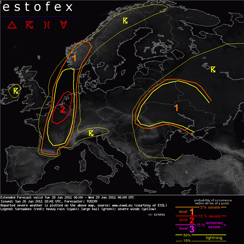
Extended Forecast
Valid: Tue 28 Jun 2011 06:00 to Wed 29 Jun 2011 06:00 UTC
Issued: Sun 26 Jun 2011 18:41
Forecaster: TUSCHY
A level 2 was issued for NE-France, Belgium, Luxembourg and the Netherlands mainly for large to very large hail (>5 cm in diameter) and severe to damaging wind gusts.
[..]
SYNOPSIS
An extensive upper trough over Ireland, Scotland and UK moves slowly eastwards during the forecast with a weakening downstream ridge present over parts of central Europe. An active cyclonic vortex over SE-Europe reveals a slight retrograde movement to the west with widespread showers and thunderstorms forecast.
DISCUSSION
... The Netherlands, Belgium, Luxembourg and parts of France ...
Upper-level forcing will be quite weak with a neutral tilted trough over the UK. Some model discrepancies concerning eastward progression remain with GFS the faster one in contrast to EZ, CMC and NOGAPS. However all models despite NOGAPS agree in scattered to widespread initiation along a slowly eastward moving cold front, which crosses the highlighted areas during the forecast from west to east. Also, the right entrance of a 40 m/s 300 hPa jet overspreads the region with additional high-level divergence. Hence, widespread initiation seems likely. FNMOC EFS and NCEP ENS mean (QPF) both agree well in highest precipitation probabilities over the S-North Sea with decreasing values over Benelux and E-France....but still augmented enough for high confidence for initiation along the eastward moving cold front. A final uncertainty arises with GFS/WRF, which develop a weak depression over Benelux, which could regionally enhance the wind field somewhat. This potential feature has to be followed closely in future model runs.
Prefrontal air mass over Benelux and E-France is characterized by rich moisture in the lower troposphere with 925 hPa dewpoints around 18°C and surface Tds in excess of 20 °C. Atop, EML fans out over the area of interest with decreasing mid-level lapse rates, but vertical temperature decrease remains strong enough for abundant CAPE build-up. While whopping 4000 J/kg MLCAPE of GFS seems unlikely, we expect 1000 to 2000 J/kg MLCAPE over the level 1 area with up to 3000 J/kg MLCAPE next to the surface boundary, where moisture pooling will be maximized (e.g. level 2 area). EZ agrees well with that scenario.
Shear remains weak over E-France but increases to 15-20 m/s 0-6 km DLS over central/NE-France and Benelux. Same with 0-3 km shear. Again, potential development of a weak surface depression over Benelux may modify kinematic environment.
Rapid to explosive thunderstorm development along the eastward moving cold front is forecast. Over central/E-France, thunderstorms will probably organize into multicells with severe downbursts and large to very large hail, especially when they remain more discrete for a longer period of time. Main concern arises over NE-France and Benelux, where indices for strong cold pool development exist. In addition, strong unidirectional shear will be present, so rapidly developing thunderstorms are forecast, which tend to line-up. Large to very large hail (> 5 cm hail in diameter) and severe wind gusts are expected. Betimes, bowing segments with swaths of severe to damaging wind gusts may evolve. Multiple rounds of severe weather are possible as thunderstorms from central France also move in during the late evening hours and onwards. Despite weak forcing and the possibility of rapid thunderstorm clustering, we think a scarce SWODY-2 level 2 is justified for this set-up, given augmented probabilities for damaging hail.
[..]
Bericht laatst bijgewerkt: 26-06-2011 20:48


