Het is inderdaad een tropische storm gebleken. In Oman zijn onder andere 14 slachtoffers gevallen.
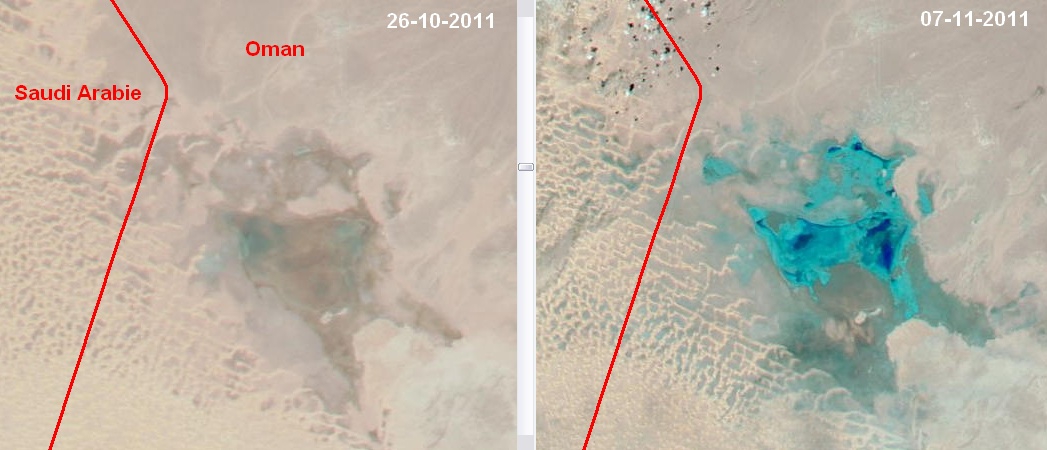
Hier onder nog een vergelijking tussen twee MODIS opnames van gisteren en bijna twee weken terug op de grens met Saudi Arabie. De regen is nog aardig het land op getrokken. De zandduinen aan de linkerkant markeren het begin van de Rub al Khali woestijn.
Interessant is ook dat er op dit moment op een vergelijkbare positie een actief complex ligt. Volgens GFS trekt de bijbehorende neerslag de komende dagen richting de kust. Zie sat24.
De RSMC zegt daarover het volgende:
Hier onder nog een vergelijking tussen twee MODIS opnames van gisteren en bijna twee weken terug op de grens met Saudi Arabie. De regen is nog aardig het land op getrokken. De zandduinen aan de linkerkant markeren het begin van de Rub al Khali woestijn.
Interessant is ook dat er op dit moment op een vergelijkbare positie een actief complex ligt. Volgens GFS trekt de bijbehorende neerslag de komende dagen richting de kust. Zie sat24.
De RSMC zegt daarover het volgende:
The Depression Over South And Adjoining Central Arabian Sea Moved Westnorthwestwards And Lay Centred At 1200 Utc Of Today, The 7Th November 2011 Over West Central Arabian Sea Near Latitude 13.50N And Longitude 60.50E, About 1550 Km West-Northwest Of Mangalore (43284), 700 Km East-Northeast Of Socotra Island (41494) And 700 Km East-Southeast Of Salalah (41316). The System Is Likely To Intensify Further Into A Deep Depression And Move Initially Westnorthwestwards And Then Northwestwards Towards Oman Coast During Next 72 Hrs.
Satellite Imagery Indicates No Significant Change In Convection And Organisation Of The System. The Intensity Of The System Is T1.5. Associated Broken Intense To Very Intense Convection Is Seen Over Arabian Sea Bet Lat 13.00N To 19.00N And Long 56.50E To 64.50E.The Lowest Cloud Top Temperature (Ctt) Due To Convection Is Around -790C In Association With The System.
Sustained Maximum Surface Wind Speed Is Estimated To Be About 25 Knots Around System Centre. The State Of The Sea Is Rough To Very Rough Around The System Centre. The Estimated Central Pressure Is About 1002 Hpa. The Ship (Position Near 12.40N And 59.20E) Reported Mslp Of 1005.0 Hpa With Tendency Of 0.0 Hpa And Wind Of 290/27 Knots. Another Ship (Position Near 12.90N And 57.30E) Reported Mslp Of 1006.3 Hpa With Tendency Of -2.2 Hpa And Wind Of 350/20 Knots.
Remark:
The Madden Julian Oscillation (Mjo) Index Currently Lies Over Phase 5 With Amplitude More Than 1. As Per The Dynamical And Statistical Models, It Would Lie Over The Same Phase During Next 2-3 Days And Then Move To Phase 6. The Phase 5 And 6 Are Not Favourable For Intensification Over The Arabian Sea. Sea Surface Temperature Is 280-290C. The Ocean Heat Content Is Less (60-80 Kj/Cm2). The Relative Vorticity At 850 Hpa Level And Upper Level Divergence Have Not Changed During Past 24 Hrs. The Vertical Wind Shear Of Horizontal Wind Over The Region Is Favourable As It Is Moderate (Between 15-20 Knots). There Is No Significant 24 Hour Tendency Of Vertical Wind Shear Around System Centre. The System Lies To The South Of Upper Tropospheric Ridge, Which Roughly Runs Along 160N. Considering All These, The System Would Intensify Further Into A Deep Depression And Move Initially Westnorthwestwards And Then Northwestwards Towards Oman Coast During Next 72 Hrs.
Bericht laatst bijgewerkt: 07-11-2011 16:26